Property Record
505 N 2Nd E, Rexburg, ID 83440
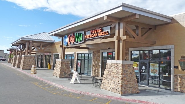

Property Detail
505 N 2Nd E
Rexburg, ID
RIVER VILLAGE LOT 1 BLK 1
RPRRVRV0010010
MADISON
Restaurantbuilding
Idaho
CBC
1
2025
2.49 AC
2025
Idaho South Area
950103
Other Market Areas
23,440 SF
NEARBY LISTINGS FOR SALE OR LEASE
DEMOGRAPHICS near 505 N 2Nd E
1 mile
3 mile
5 mile
2024 Total Population
8,693
46,816
51,240
2029 Population
8,948
48,601
53,174
Pop Growth 2024-2029
+ 2.93%
+ 3.81%
+ 3.77%
Average Age
28
27
28
2024 Total Households
1,921
10,972
12,221
HH Growth 2024-2029
+ 3.33%
+ 4.70%
+ 4.61%
Median Household Inc
$51,913
$53,770
$56,230
Avg Household Size
2.90
2.90
2.90
2024 Avg HH Vehicles
2.00
2.00
2.00
Median Home Value
$396,376
$428,802
$431,550
Median Year Built
1986
2005
2004
Nearby Places
Map Layers
Map Styles
 Street
 Aerial
Transit
 Traffic
 Biking
Places
Listings with unknown addresses are not visible on the map
- Restaurants
- Banks
- Shops
- Fitness
- Groceries
PUBLIC TRANSPORTATION
AIRPORT
Idaho Falls Regional
Drive
Walk
Distance
Idaho Falls Regional
36 min
29.6 mi
SALE & LEASE HISTORY
LISTING DATE
SALE/LEASE

Sep 25, 2016
For Lease
Sep 24, 2016
For Sale
Dec 06, 2017
For Lease
Nearby Properties
Address
Land Use
TOTAL SIZE
Lot Size
Zoning
Address
Land Use
TOTAL SIZE
Lot Size
Zoning
411,328 SF
16.59 AC
HDR1
Address
Land Use
TOTAL SIZE
Lot Size
Zoning
125.56 AC
HI
Address
Land Use
TOTAL SIZE
Lot Size
Zoning
125,338 SF
5.58 AC
HDR1
Address
Land Use
TOTAL SIZE
Lot Size
Zoning
3.07 AC
CORE-T
Address
Land Use
TOTAL SIZE
Lot Size
Zoning
20,116 SF
10.44 AC
MDR2
Address
Land Use
TOTAL SIZE
Lot Size
Zoning
194,411 SF
17.15 AC
RBC
Address
Land Use
TOTAL SIZE
Lot Size
Zoning
269,479 SF
5.07 AC
HDR2
Address
Land Use
TOTAL SIZE
Lot Size
Zoning
8.66 AC
MDR2
Address
Land Use
TOTAL SIZE
Lot Size
Zoning
145,966 SF
4.31 AC
HDR1
Address
Land Use
TOTAL SIZE
Lot Size
Zoning
11,211 SF
6 AC
HDR2
Address
Land Use
TOTAL SIZE
Lot Size
Zoning
5,352 SF
9.54 AC
HDR1
Address
Land Use
TOTAL SIZE
Lot Size
Zoning
74,205 SF
3.10 AC
HDR2
Address
Land Use
TOTAL SIZE
Lot Size
Zoning
1.14 AC
PRO
Address
Land Use
TOTAL SIZE
Lot Size
Zoning
1.05 AC
PRO
Address
Land Use
TOTAL SIZE
Lot Size
Zoning
75,612 SF
4.05 AC
MDR1
Address
Land Use
TOTAL SIZE
Lot Size
Zoning
46,720 SF
2.20 AC
HDR2
Address
Land Use
TOTAL SIZE
Lot Size
Zoning
126,600 SF
7.05 AC
CBC
Address
Land Use
TOTAL SIZE
Lot Size
Zoning
8,880 SF
4.12 AC
HDR2
Address
Land Use
TOTAL SIZE
Lot Size
Zoning
99,296 SF
4.56 AC
HDR1
Address
Land Use
TOTAL SIZE
Lot Size
Zoning
78,645 SF
2.77 AC
HDR1
Address
Land Use
TOTAL SIZE
Lot Size
Zoning
10 AC
SUGAR
Address
Land Use
TOTAL SIZE
Lot Size
Zoning
16,722 SF
4.97 AC
HDR1
Address
Land Use
TOTAL SIZE
Lot Size
Zoning
72,814 SF
1.60 AC
HDR2
Address
Land Use
TOTAL SIZE
Lot Size
Zoning
4,124 SF
1.19 AC
HDR2
Address
Land Use
TOTAL SIZE
Lot Size
Zoning
30.46 AC
LI
Address
Land Use
TOTAL SIZE
Lot Size
Zoning
108,924 SF
1.07 AC
CC-T
Address
Land Use
TOTAL SIZE
Lot Size
Zoning
84,823 SF
2.67 AC
MU
Address
Land Use
TOTAL SIZE
Lot Size
Zoning
77,577 SF
4.63 AC
CC-T
The World's #1 Commercial Real Estate Marketplace
Connect with us
© 2026 CoStar Group
The information above has been obtained from sources believed reliable. While we do not doubt its accuracy we have not verified it and make no guarantee, warranty or representation about it. It is your responsibility to independently confirm its accuracy and completeness. Any projections, opinions, assumptions, or estimates used are for example only and do not represent the current or future performance of the property. The value of this transaction to you depends on tax and other factors which should be evaluated by your tax, financial, and legal advisors. You and your advisors should conduct a careful, independent investigation of the property to determine to your satisfaction the suitability of the property for your needs.