Property Record
505 N Clay St, Greenville, MI 48838
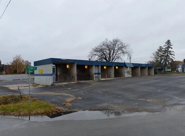
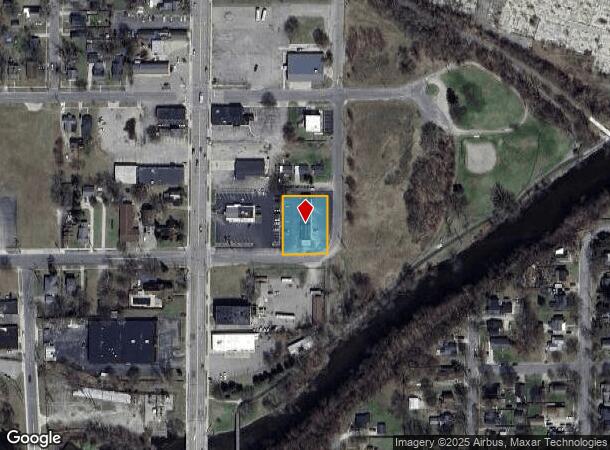
This Property Is For Sale
NEARBY LISTINGS FOR SALE OR LEASE
-
-
View all Greenville listings for sale on LoopNet.com
Property Detail
505 N Clay St
Other Market Areas
Backus & Churches Addition
Grand Rapids-Wyoming, MI
. . E 130 FT OF LOTS 9, 10 & 11 BACKUS & CHURCHES ADDITION TO VILLAGE (NOW CITY) OF GREENVILLE.
052-235-009-50
Montcalm
Commercialnec
Michigan
2025
9-11
2025
0.48 AC
971300
Michigan North Central Area
DEMOGRAPHICS near 505 N Clay St
1 Mile
3 Mile
5 Mile
2024 Total Population
5,746
12,397
16,904
2029 Population
5,802
12,592
17,273
Pop Growth 2024-2029
+ 0.97%
+ 1.57%
+ 2.18%
Average Age
39
40
41
2024 Total Households
2,337
4,920
6,668
HH Growth 2024-2029
+ 1.03%
+ 1.59%
+ 2.19%
Median Household Inc
$64,777
$66,531
$69,507
Avg Household Size
2.30
2.40
2.40
2024 Avg HH Vehicles
2.00
2.00
2.00
Median Home Value
$175,121
$197,537
$219,532
Median Year Built
1957
1971
1974
Nearby Places
Map Layers
Map Styles
 Street
 Aerial
- Restaurants
- Banks
- Shops
- Fitness
- Groceries
PUBLIC TRANSPORTATION
AIRPORT
Gerald R Ford International
DRIVE
WALK
Distance
Gerald R Ford International
61 min
39.8 mi
Nearby Properties
Address
Land Use
TOTAL SIZE
Lot Size
Zoning
Address
Land Use
TOTAL SIZE
Lot Size
Zoning
Address
Land Use
TOTAL SIZE
Lot Size
Zoning
Address
Land Use
TOTAL SIZE
Lot Size
Zoning
37.29 AC
R-1
Address
Land Use
TOTAL SIZE
Lot Size
Zoning
31.05 AC
C-2
Address
Land Use
TOTAL SIZE
Lot Size
Zoning
11.06 AC
Address
Land Use
TOTAL SIZE
Lot Size
Zoning
10.39 AC
R-1
Address
Land Use
TOTAL SIZE
Lot Size
Zoning
42.80 AC
IND
Address
Land Use
TOTAL SIZE
Lot Size
Zoning
96.66 AC
IND
Address
Land Use
TOTAL SIZE
Lot Size
Zoning
6.03 AC
IND
Address
Land Use
TOTAL SIZE
Lot Size
Zoning
11.90 AC
C-2
Address
Land Use
TOTAL SIZE
Lot Size
Zoning
7.57 AC
IND
Address
Land Use
TOTAL SIZE
Lot Size
Zoning
1.65 AC
Address
Land Use
TOTAL SIZE
Lot Size
Zoning
7.88 AC
C-2
Address
Land Use
TOTAL SIZE
Lot Size
Zoning
Address
Land Use
TOTAL SIZE
Lot Size
Zoning
5.64 AC
IND
Address
Land Use
TOTAL SIZE
Lot Size
Zoning
11.61 AC
IND
Address
Land Use
TOTAL SIZE
Lot Size
Zoning
2.40 AC
IND
Address
Land Use
TOTAL SIZE
Lot Size
Zoning
4.67 AC
Address
Land Use
TOTAL SIZE
Lot Size
Zoning
3.42 AC
C-2
Address
Land Use
TOTAL SIZE
Lot Size
Zoning
13.45 AC
PC
Address
Land Use
TOTAL SIZE
Lot Size
Zoning
Address
Land Use
TOTAL SIZE
Lot Size
Zoning
Address
Land Use
TOTAL SIZE
Lot Size
Zoning
9.61 AC
IND
Address
Land Use
TOTAL SIZE
Lot Size
Zoning
6.09 AC
IND
Address
Land Use
TOTAL SIZE
Lot Size
Zoning
4.95 AC
OSC-2
Address
Land Use
TOTAL SIZE
Lot Size
Zoning
4.46 AC
IND
Address
Land Use
TOTAL SIZE
Lot Size
Zoning
2.78 AC
C-2
Address
Land Use
TOTAL SIZE
Lot Size
Zoning
4.88 AC
Address
Land Use
TOTAL SIZE
Lot Size
Zoning
11.50 AC
R-3
Address
Land Use
TOTAL SIZE
Lot Size
Zoning
1.71 AC
C-2
The World's #1 Commercial Real Estate Marketplace
Connect with us
© 2026 CoStar Group
The information above has been obtained from sources believed reliable. While we do not doubt its accuracy we have not verified it and make no guarantee, warranty or representation about it. It is your responsibility to independently confirm its accuracy and completeness. Any projections, opinions, assumptions, or estimates used are for example only and do not represent the current or future performance of the property. The value of this transaction to you depends on tax and other factors which should be evaluated by your tax, financial, and legal advisors. You and your advisors should conduct a careful, independent investigation of the property to determine to your satisfaction the suitability of the property for your needs.