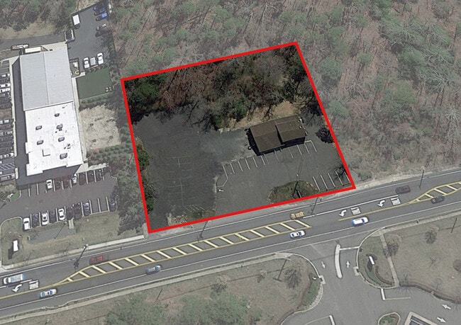
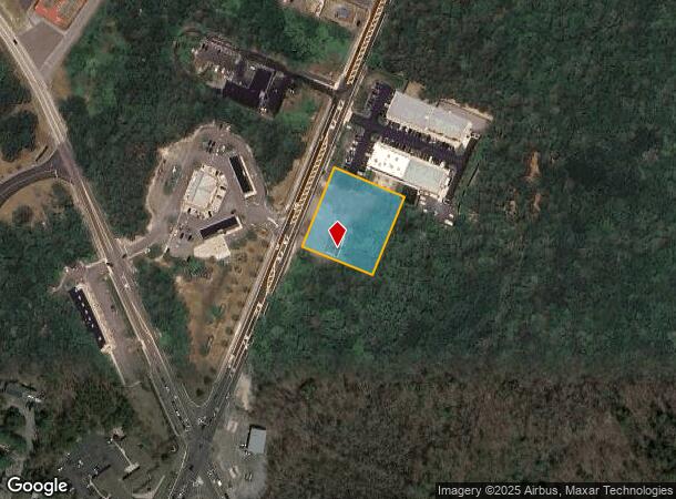
Property Record
505 N Main St, Barnegat, NJ 08005
Current Lease Availabilities
NEARBY LISTINGS FOR SALE OR LEASE
Property Detail
505 N Main St
31-00296-0000-00106
235X200
Commercialnec
Ocean
X
New Jersey
34029C0485G
106
2024
1.08 AC
2025
Ocean County
734002
Northern New Jersey
2,670 SF
New York-Jersey City-White Plains, NY-NJ
DEMOGRAPHICS near 505 N Main St
1 Mile
3 Mile
5 Mile
2024 Total Population
2,051
29,964
59,951
2029 Population
2,188
32,296
64,936
Pop Growth 2024-2029
+ 6.68%
+ 7.78%
+ 8.32%
Average Age
40
41
43
2024 Total Households
757
10,984
23,214
HH Growth 2024-2029
+ 6.47%
+ 7.74%
+ 8.16%
Median Household Inc
$85,775
$89,864
$89,356
Avg Household Size
2.70
2.60
2.50
2024 Avg HH Vehicles
2.00
2.00
2.00
Median Home Value
$390,883
$307,618
$323,414
Median Year Built
1986
1989
1992
Nearby Places
Map Layers
Map Styles
 Street
 Aerial
- Restaurants
- Banks
- Shops
- Fitness
- Groceries
PUBLIC TRANSPORTATION
AIRPORT
Atlantic City International
DRIVE
WALK
Distance
Atlantic City International
61 min
32.4 mi
Freight Ports
Broadway Terminal - Pier 5
DRIVE
WALK
Distance
Broadway Terminal - Pier 5
68 min
54.8 mi
Nearby Properties
Address
Land Use
TOTAL SIZE
Lot Size
Zoning
Address
Land Use
TOTAL SIZE
Lot Size
Zoning
129 AC
PU
Address
Land Use
TOTAL SIZE
Lot Size
Zoning
107,490 SF
30 AC
HC
Address
Land Use
TOTAL SIZE
Lot Size
Zoning
21.78 AC
HMC
Address
Land Use
TOTAL SIZE
Lot Size
Zoning
15.71 AC
BP
Address
Land Use
TOTAL SIZE
Lot Size
Zoning
22.43 AC
BP
Address
Land Use
TOTAL SIZE
Lot Size
Zoning
12.04 AC
BP
Address
Land Use
TOTAL SIZE
Lot Size
Zoning
15.03 AC
BP
Address
Land Use
TOTAL SIZE
Lot Size
Zoning
9,920 SF
20.75 AC
HC
Address
Land Use
TOTAL SIZE
Lot Size
Zoning
4,232 SF
119.80 AC
R3P/
Address
Land Use
TOTAL SIZE
Lot Size
Zoning
125,352 SF
12.86 AC
HC
Address
Land Use
TOTAL SIZE
Lot Size
Zoning
118,850 SF
21.73 AC
HC
Address
Land Use
TOTAL SIZE
Lot Size
Zoning
100,988 SF
7.72 AC
HC
Address
Land Use
TOTAL SIZE
Lot Size
Zoning
4,479 SF
18.27 AC
MU
Address
Land Use
TOTAL SIZE
Lot Size
Zoning
44.75 AC
MLS/
Address
Land Use
TOTAL SIZE
Lot Size
Zoning
13.99 AC
MLSC
Address
Land Use
TOTAL SIZE
Lot Size
Zoning
55,605 SF
9.25 AC
HC
Address
Land Use
TOTAL SIZE
Lot Size
Zoning
91.97 AC
RGL/
Address
Land Use
TOTAL SIZE
Lot Size
Zoning
28.01 AC
BP
Address
Land Use
TOTAL SIZE
Lot Size
Zoning
116,625 SF
17.46 AC
HC
Address
Land Use
TOTAL SIZE
Lot Size
Zoning
101,202 SF
16.10 AC
HC
Address
Land Use
TOTAL SIZE
Lot Size
Zoning
7.54 AC
BP
Address
Land Use
TOTAL SIZE
Lot Size
Zoning
11.06 AC
MLS/
Address
Land Use
TOTAL SIZE
Lot Size
Zoning
8,300 SF
1.07 AC
HMC/
Address
Land Use
TOTAL SIZE
Lot Size
Zoning
9.86 AC
RA4/
Address
Land Use
TOTAL SIZE
Lot Size
Zoning
6.21 AC
BP
Address
Land Use
TOTAL SIZE
Lot Size
Zoning
3.81 AC
HMC
Address
Land Use
TOTAL SIZE
Lot Size
Zoning
37.27 AC
RGL/
Address
Land Use
TOTAL SIZE
Lot Size
Zoning
6.36 AC
RGL/
Address
Land Use
TOTAL SIZE
Lot Size
Zoning
52,572 SF
6.74 AC
HC
Address
Land Use
TOTAL SIZE
Lot Size
Zoning
44,487 SF
10.42 AC
HC
The World's #1 Commercial Real Estate Marketplace
Connect with us
© 2026 CoStar Group
The information above has been obtained from sources believed reliable. While we do not doubt its accuracy we have not verified it and make no guarantee, warranty or representation about it. It is your responsibility to independently confirm its accuracy and completeness. Any projections, opinions, assumptions, or estimates used are for example only and do not represent the current or future performance of the property. The value of this transaction to you depends on tax and other factors which should be evaluated by your tax, financial, and legal advisors. You and your advisors should conduct a careful, independent investigation of the property to determine to your satisfaction the suitability of the property for your needs.