Property Record
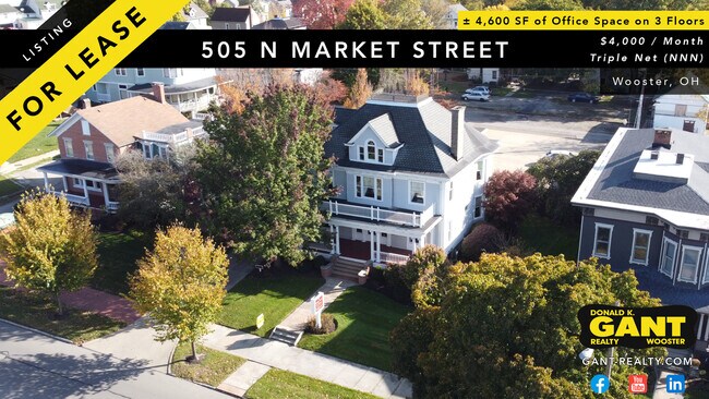
505 N Market St, Wooster, OH 44691


Current Lease Availabilities
NEARBY LISTINGS FOR SALE OR LEASE
Property Detail
505 N Market St
64-01611-000
SPT LOT 506 36.33' 1/2 VAC ALY MP 49 CD 1773
Officebuilding
Wayne
X
Ohio
39169C0212E
506
2024
0.15 AC
2024
Ohio North Area
000100
Other Market Areas
4,600 SF
Wooster, OH
DEMOGRAPHICS near 505 N Market St
1 Mile
3 Mile
5 Mile
2024 Total Population
10,504
29,889
39,741
2029 Population
10,644
30,207
40,057
Pop Growth 2024-2029
+ 1.33%
+ 1.06%
+ 0.80%
Average Age
36
40
41
2024 Total Households
3,847
11,968
16,042
HH Growth 2024-2029
+ 1.40%
+ 1.02%
+ 0.71%
Median Household Inc
$45,901
$55,058
$56,946
Avg Household Size
2.20
2.20
2.20
2024 Avg HH Vehicles
1.00
2.00
2.00
Median Home Value
$128,283
$175,512
$183,518
Median Year Built
1949
1972
1975
Nearby Places
Map Layers
Map Styles
 Street
 Aerial
- Restaurants
- Banks
- Shops
- Fitness
- Groceries
PUBLIC TRANSPORTATION
AIRPORT
Akron-Canton Regional
DRIVE
WALK
Distance
Akron-Canton Regional
54 min
42.9 mi
Freight Ports
Port of Toledo
DRIVE
WALK
Distance
Port of Toledo
164 min
118.9 mi
Nearby Properties
Address
Land Use
TOTAL SIZE
Lot Size
Zoning
Address
Land Use
TOTAL SIZE
Lot Size
Zoning
537,309 SF
43.72 AC
CF
Address
Land Use
TOTAL SIZE
Lot Size
Zoning
70,726 SF
9 AC
CF
Address
Land Use
TOTAL SIZE
Lot Size
Zoning
2,268 SF
106.60 AC
CF
Address
Land Use
TOTAL SIZE
Lot Size
Zoning
152,523 SF
74.14 AC
CF
Address
Land Use
TOTAL SIZE
Lot Size
Zoning
81,133 SF
41.43 AC
CF
Address
Land Use
TOTAL SIZE
Lot Size
Zoning
51.79 AC
M2
Address
Land Use
TOTAL SIZE
Lot Size
Zoning
7.28 AC
CF
Address
Land Use
TOTAL SIZE
Lot Size
Zoning
227,500 SF
58.38 AC
Address
Land Use
TOTAL SIZE
Lot Size
Zoning
2,400 SF
99.04 AC
CF
Address
Land Use
TOTAL SIZE
Lot Size
Zoning
48,096 SF
1.67 AC
C4
Address
Land Use
TOTAL SIZE
Lot Size
Zoning
109.56 AC
M2
Address
Land Use
TOTAL SIZE
Lot Size
Zoning
50,110 SF
19.26 AC
CF
Address
Land Use
TOTAL SIZE
Lot Size
Zoning
25.14 AC
CF
Address
Land Use
TOTAL SIZE
Lot Size
Zoning
62,910 SF
11.24 AC
C5
Address
Land Use
TOTAL SIZE
Lot Size
Zoning
47,160 SF
3.22 AC
C4
Address
Land Use
TOTAL SIZE
Lot Size
Zoning
4,486 SF
5.57 AC
CF
Address
Land Use
TOTAL SIZE
Lot Size
Zoning
210,000 SF
20 AC
Address
Land Use
TOTAL SIZE
Lot Size
Zoning
2,536 SF
16.79 AC
R4
Address
Land Use
TOTAL SIZE
Lot Size
Zoning
85,910 SF
4.33 AC
Address
Land Use
TOTAL SIZE
Lot Size
Zoning
105,000 SF
25.29 AC
M2
Address
Land Use
TOTAL SIZE
Lot Size
Zoning
62,976 SF
10.46 AC
CF
Address
Land Use
TOTAL SIZE
Lot Size
Zoning
302,400 SF
24.51 AC
M2
Address
Land Use
TOTAL SIZE
Lot Size
Zoning
71,631 SF
17.88 AC
M1
Address
Land Use
TOTAL SIZE
Lot Size
Zoning
58,600 SF
6.30 AC
CF
Address
Land Use
TOTAL SIZE
Lot Size
Zoning
81,724 SF
19.59 AC
CF
Address
Land Use
TOTAL SIZE
Lot Size
Zoning
10.68 AC
M3
Address
Land Use
TOTAL SIZE
Lot Size
Zoning
71,511 SF
9.53 AC
CF
Address
Land Use
TOTAL SIZE
Lot Size
Zoning
41,173 SF
6.77 AC
Address
Land Use
TOTAL SIZE
Lot Size
Zoning
5,156 SF
2.68 AC
R1
Address
Land Use
TOTAL SIZE
Lot Size
Zoning
6,120 SF
12.43 AC
R4
The World's #1 Commercial Real Estate Marketplace
Connect with us
© 2026 CoStar Group
The information above has been obtained from sources believed reliable. While we do not doubt its accuracy we have not verified it and make no guarantee, warranty or representation about it. It is your responsibility to independently confirm its accuracy and completeness. Any projections, opinions, assumptions, or estimates used are for example only and do not represent the current or future performance of the property. The value of this transaction to you depends on tax and other factors which should be evaluated by your tax, financial, and legal advisors. You and your advisors should conduct a careful, independent investigation of the property to determine to your satisfaction the suitability of the property for your needs.