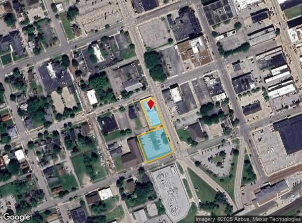
Property Record
505 S 3Rd St, Elkhart, IN 46516
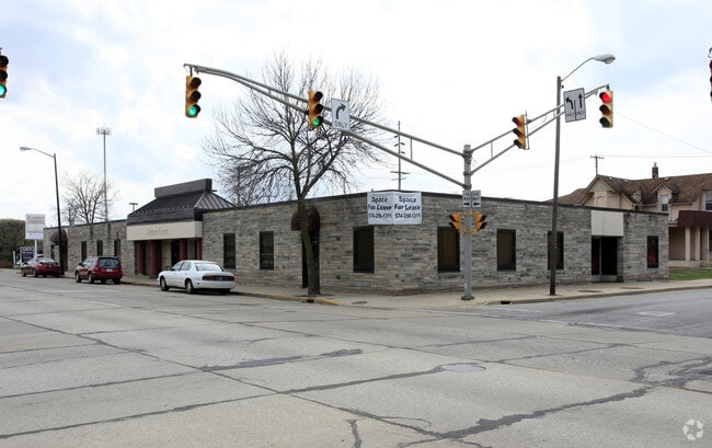

This Property Is For Sale
NEARBY LISTINGS FOR SALE OR LEASE
Property Detail
505 S 3Rd St
Elkhart-Goshen, IN
Second South & Western
20-06-05-456-013.000-012
SECOND SOUTH & WESTERN LOTS 256 & 257 & LOT 247 EX W 8FT (TIF 75)
Officebuilding
Elkhart
X
Indiana
18039C0136D
256,2
2023
0.91 AC
2024
Downtown Elkhart
002700
South Bend/Mishawaka
12,228 SF
DEMOGRAPHICS near 505 S 3Rd St
1 Mile
3 Mile
5 Mile
2024 Total Population
16,656
62,629
101,871
2029 Population
16,976
62,922
101,997
Pop Growth 2024-2029
+ 1.92%
+ 0.47%
+ 0.12%
Average Age
35
37
38
2024 Total Households
6,082
23,429
38,377
HH Growth 2024-2029
+ 2.27%
+ 0.52%
+ 0.15%
Median Household Inc
$37,766
$47,006
$54,325
Avg Household Size
2.50
2.50
2.60
2024 Avg HH Vehicles
1.00
2.00
2.00
Median Home Value
$84,010
$120,103
$153,495
Median Year Built
1948
1963
1973
Nearby Places
Map Layers
Map Styles
 Street
 Aerial
- Restaurants
- Banks
- Shops
- Fitness
- Groceries
PUBLIC TRANSPORTATION
COMMUTER RAIL
DRIVE
WALK
Distance
1 min
5 min
0.2 mi
AIRPORT
South Bend International
DRIVE
WALK
Distance
South Bend International
46 min
29.2 mi
Nearby Properties
Address
Land Use
TOTAL SIZE
Lot Size
Zoning
Address
Land Use
TOTAL SIZE
Lot Size
Zoning
373,218 SF
14.58 AC
ZO01
Address
Land Use
TOTAL SIZE
Lot Size
Zoning
133,214 SF
0.30 AC
ZO01
Address
Land Use
TOTAL SIZE
Lot Size
Zoning
630,852 SF
37.12 AC
ZO01
Address
Land Use
TOTAL SIZE
Lot Size
Zoning
59,994 SF
46.12 AC
ZO01
Address
Land Use
TOTAL SIZE
Lot Size
Zoning
243,442 SF
6.54 AC
ZO01
Address
Land Use
TOTAL SIZE
Lot Size
Zoning
334,473 SF
24.88 AC
ZO01
Address
Land Use
TOTAL SIZE
Lot Size
Zoning
333,124 SF
16.47 AC
ZO01
Address
Land Use
TOTAL SIZE
Lot Size
Zoning
158,688 SF
20.79 AC
ZO01
Address
Land Use
TOTAL SIZE
Lot Size
Zoning
106,029 SF
35.15 AC
ZO01
Address
Land Use
TOTAL SIZE
Lot Size
Zoning
278,692 SF
13.86 AC
ZO01
Address
Land Use
TOTAL SIZE
Lot Size
Zoning
203,685 SF
17.74 AC
ZO01
Address
Land Use
TOTAL SIZE
Lot Size
Zoning
92,926 SF
14.29 AC
Address
Land Use
TOTAL SIZE
Lot Size
Zoning
129,147 SF
3.23 AC
Address
Land Use
TOTAL SIZE
Lot Size
Zoning
301,018 SF
19.68 AC
ZO01
Address
Land Use
TOTAL SIZE
Lot Size
Zoning
78,006 SF
8.10 AC
ZO01
Address
Land Use
TOTAL SIZE
Lot Size
Zoning
294,230 SF
22.37 AC
ZO01
Address
Land Use
TOTAL SIZE
Lot Size
Zoning
289,195 SF
48.88 AC
ZO01
Address
Land Use
TOTAL SIZE
Lot Size
Zoning
199,800 SF
13 AC
ZO01
Address
Land Use
TOTAL SIZE
Lot Size
Zoning
56,310 SF
2.85 AC
ZO01
Address
Land Use
TOTAL SIZE
Lot Size
Zoning
258,244 SF
9.99 AC
ZO01
Address
Land Use
TOTAL SIZE
Lot Size
Zoning
203,942 SF
32.52 AC
ZO01
Address
Land Use
TOTAL SIZE
Lot Size
Zoning
223,713 SF
14.05 AC
ZO01
Address
Land Use
TOTAL SIZE
Lot Size
Zoning
47,936 SF
0.92 AC
ZO01
Address
Land Use
TOTAL SIZE
Lot Size
Zoning
89,295 SF
4.03 AC
ZO01
Address
Land Use
TOTAL SIZE
Lot Size
Zoning
65,387 SF
7.72 AC
ZO01
Address
Land Use
TOTAL SIZE
Lot Size
Zoning
425,363 SF
32.52 AC
ZO01
Address
Land Use
TOTAL SIZE
Lot Size
Zoning
240,587 SF
12 AC
ZO01
Address
Land Use
TOTAL SIZE
Lot Size
Zoning
155,600 SF
10.53 AC
ZO01
Address
Land Use
TOTAL SIZE
Lot Size
Zoning
129,039 SF
12.56 AC
ZO01
Address
Land Use
TOTAL SIZE
Lot Size
Zoning
71,977 SF
8.60 AC
The World's #1 Commercial Real Estate Marketplace
Connect with us
© 2025 CoStar Group
The information above has been obtained from sources believed reliable. While we do not doubt its accuracy we have not verified it and make no guarantee, warranty or representation about it. It is your responsibility to independently confirm its accuracy and completeness. Any projections, opinions, assumptions, or estimates used are for example only and do not represent the current or future performance of the property. The value of this transaction to you depends on tax and other factors which should be evaluated by your tax, financial, and legal advisors. You and your advisors should conduct a careful, independent investigation of the property to determine to your satisfaction the suitability of the property for your needs.