Property Record
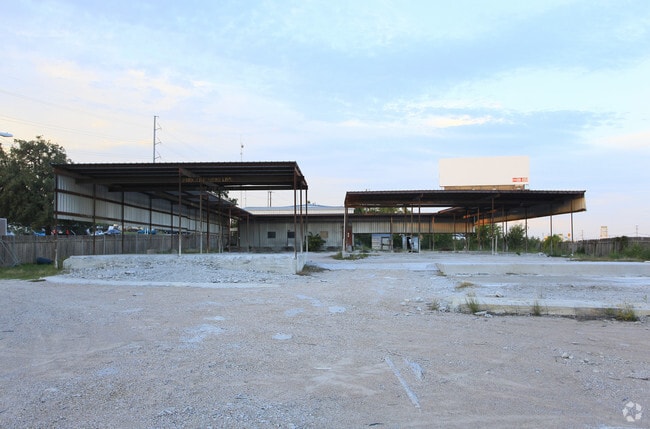
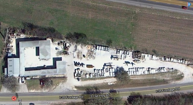
505 S Old Highway 81, Kyle, TX 78640

Property Detail
505 S Old Highway 81
R14726
ABS 220 Z HINTON SURVEY 1.537 AC
Commercialnec
HAYS
B and X Area of moderate flood hazard, usually the area between the limits of the 100-year and 500-year floods.
Texas
2024
1.54 AC
2025
Hays County
010916
Austin
2,200 SF
Austin-Round Rock-San Marcos, TX
NEARBY LISTINGS FOR SALE OR LEASE
DEMOGRAPHICS near 505 S Old Highway 81
1 mile
3 mile
5 mile
2024 Total Population
8,126
53,320
84,047
2029 Population
10,687
70,320
111,060
Pop Growth 2024-2029
+ 31.52%
+ 31.88%
+ 32.14%
Average Age
36
35
35
2024 Total Households
2,682
18,396
28,281
HH Growth 2024-2029
+ 32.55%
+ 32.96%
+ 33.18%
Median Household Inc
$91,572
$91,964
$84,531
Avg Household Size
3.00
2.90
2.90
2024 Avg HH Vehicles
2.00
2.00
2.00
Median Home Value
$259,675
$269,385
$262,576
Median Year Built
2008
2010
2010
Nearby Places
Map Layers
Map Styles
 Street
 Aerial
Transit
 Traffic
 Biking
Places
Listings with unknown addresses are not visible on the map
- Restaurants
- Banks
- Shops
- Fitness
- Groceries
PUBLIC TRANSPORTATION
COMMUTER RAIL
San Marcos Amtrak (Texas Eagle - Amtrak)
Drive
Walk
Distance
San Marcos Amtrak (Texas Eagle - Amtrak)
14 min
9.4 mi
AIRPORT
Austin-Bergstrom International
Drive
Walk
Distance
Austin-Bergstrom International
37 min
27.4 mi
Freight Ports
Calhoun Port
Drive
Walk
Distance
Calhoun Port
172 min
141.9 mi
SALE & LEASE HISTORY
LISTING DATE
SALE/LEASE

Feb 05, 2019
For Sale
Nearby Properties
Address
Land Use
TOTAL SIZE
Lot Size
Zoning
Address
Land Use
TOTAL SIZE
Lot Size
Zoning
1,647,300 SF
96.81 AC
Address
Land Use
TOTAL SIZE
Lot Size
Zoning
331,761 SF
57.23 AC
Address
Land Use
TOTAL SIZE
Lot Size
Zoning
319,545 SF
13.74 AC
Address
Land Use
TOTAL SIZE
Lot Size
Zoning
301,745 SF
16.14 AC
Address
Land Use
TOTAL SIZE
Lot Size
Zoning
201,966 SF
33.54 AC
Address
Land Use
TOTAL SIZE
Lot Size
Zoning
233,088 SF
12.36 AC
Address
Land Use
TOTAL SIZE
Lot Size
Zoning
421,200 SF
14.39 AC
Address
Land Use
TOTAL SIZE
Lot Size
Zoning
491,520 SF
38.84 AC
Address
Land Use
TOTAL SIZE
Lot Size
Zoning
383,970 SF
17.76 AC
Address
Land Use
TOTAL SIZE
Lot Size
Zoning
230,002 SF
6.07 AC
Address
Land Use
TOTAL SIZE
Lot Size
Zoning
240,002 SF
53.46 AC
Address
Land Use
TOTAL SIZE
Lot Size
Zoning
158,169 SF
14 AC
Address
Land Use
TOTAL SIZE
Lot Size
Zoning
240,168 SF
9.45 AC
Address
Land Use
TOTAL SIZE
Lot Size
Zoning
234,794 SF
10.07 AC
Address
Land Use
TOTAL SIZE
Lot Size
Zoning
193,470 SF
7.42 AC
Address
Land Use
TOTAL SIZE
Lot Size
Zoning
78,088 SF
7 AC
Address
Land Use
TOTAL SIZE
Lot Size
Zoning
258,960 SF
18.31 AC
Address
Land Use
TOTAL SIZE
Lot Size
Zoning
62,202 SF
5.14 AC
Address
Land Use
TOTAL SIZE
Lot Size
Zoning
96.18 AC
Address
Land Use
TOTAL SIZE
Lot Size
Zoning
73,518 SF
12.79 AC
Address
Land Use
TOTAL SIZE
Lot Size
Zoning
133,502 SF
4.24 AC
Address
Land Use
TOTAL SIZE
Lot Size
Zoning
156,634 SF
3.89 AC
Address
Land Use
TOTAL SIZE
Lot Size
Zoning
112,616 SF
8.61 AC
Address
Land Use
TOTAL SIZE
Lot Size
Zoning
50,507 SF
3.19 AC
Address
Land Use
TOTAL SIZE
Lot Size
Zoning
924 SF
166.72 AC
Address
Land Use
TOTAL SIZE
Lot Size
Zoning
116,625 SF
19.01 AC
Address
Land Use
TOTAL SIZE
Lot Size
Zoning
63,875 SF
5.82 AC
Address
Land Use
TOTAL SIZE
Lot Size
Zoning
117,084 SF
5.45 AC
Address
Land Use
TOTAL SIZE
Lot Size
Zoning
97,976 SF
12.20 AC
Address
Land Use
TOTAL SIZE
Lot Size
Zoning
212,801 SF
5.72 AC
The World's #1 Commercial Real Estate Marketplace
Connect with us
© 2026 CoStar Group
The information above has been obtained from sources believed reliable. While we do not doubt its accuracy we have not verified it and make no guarantee, warranty or representation about it. It is your responsibility to independently confirm its accuracy and completeness. Any projections, opinions, assumptions, or estimates used are for example only and do not represent the current or future performance of the property. The value of this transaction to you depends on tax and other factors which should be evaluated by your tax, financial, and legal advisors. You and your advisors should conduct a careful, independent investigation of the property to determine to your satisfaction the suitability of the property for your needs.