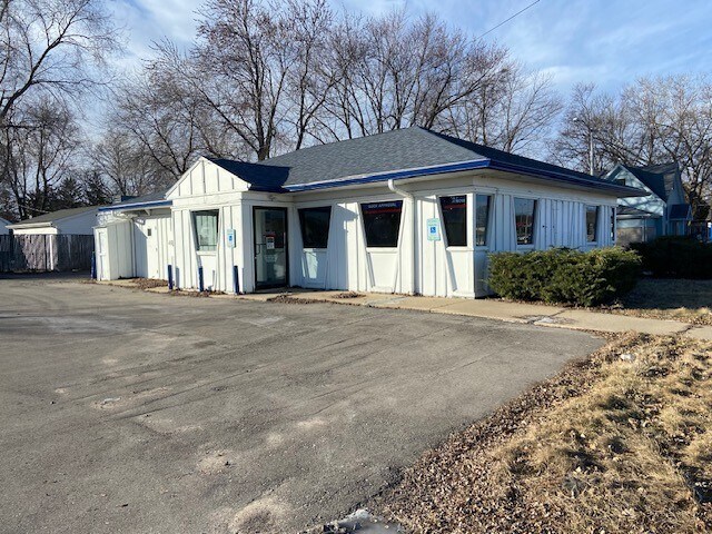
Property Record
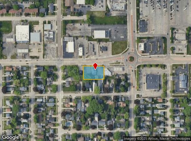
505 W Murdock Ave, Oshkosh, WI 54901
Current Lease Availabilities
NEARBY LISTINGS FOR SALE OR LEASE
Property Detail
505 W Murdock Ave
Oshkosh-Neenah, WI
Mastersons Park Plat
12-09630000
LOTS 8, 9, 10 & E 40 FT OF LOT 11 BLK 7 MASTERSONS PARK PLATEXC THAT PRT IN DOC #1515224 R OF D
Commercialnec
Winnebago
X
Wisconsin
55139C0220E
11
2024
0.50 AC
2024
Appleton/Oshkosh
000800
Other Market Areas
1,920 SF
DEMOGRAPHICS near 505 W Murdock Ave
1 Mile
3 Mile
5 Mile
2024 Total Population
16,524
58,180
76,651
2029 Population
16,457
58,427
76,947
Pop Growth 2024-2029
(0.41%)
+ 0.42%
+ 0.39%
Average Age
35
39
39
2024 Total Households
6,193
24,244
31,785
HH Growth 2024-2029
(0.23%)
+ 0.72%
+ 0.60%
Median Household Inc
$50,091
$54,394
$59,796
Avg Household Size
2.20
2.10
2.20
2024 Avg HH Vehicles
2.00
2.00
2.00
Median Home Value
$144,211
$154,933
$172,950
Median Year Built
1956
1965
1972
Nearby Places
- Restaurants
- Banks
- Shops
- Fitness
- Groceries
PUBLIC TRANSPORTATION
AIRPORT
Appleton International
DRIVE
WALK
Distance
Appleton International
27 min
19.1 mi
Freight Ports
Port Milwaukee
DRIVE
WALK
Distance
Port Milwaukee
107 min
91.1 mi
Nearby Properties
Address
Land Use
TOTAL SIZE
Lot Size
Zoning
Address
Land Use
TOTAL SIZE
Lot Size
Zoning
32.81 AC
CBPPD
Address
Land Use
TOTAL SIZE
Lot Size
Zoning
7.74 AC
Address
Land Use
TOTAL SIZE
Lot Size
Zoning
195,810 SF
31.08 AC
MR-20
Address
Land Use
TOTAL SIZE
Lot Size
Zoning
208,278 SF
22.77 AC
C2
Address
Land Use
TOTAL SIZE
Lot Size
Zoning
255,080 SF
21.29 AC
MR-12
Address
Land Use
TOTAL SIZE
Lot Size
Zoning
552,602 SF
7.28 AC
M3
Address
Land Use
TOTAL SIZE
Lot Size
Zoning
128,951 SF
4.95 AC
R1
Address
Land Use
TOTAL SIZE
Lot Size
Zoning
485,007 SF
41.76 AC
M3
Address
Land Use
TOTAL SIZE
Lot Size
Zoning
195,847 SF
4.66 AC
UMU-PD
Address
Land Use
TOTAL SIZE
Lot Size
Zoning
14.77 AC
SMU-PD
Address
Land Use
TOTAL SIZE
Lot Size
Zoning
2.29 AC
RMUPDRFO
Address
Land Use
TOTAL SIZE
Lot Size
Zoning
140,184 SF
17.35 AC
MR-20-PD
Address
Land Use
TOTAL SIZE
Lot Size
Zoning
70,672 SF
4.97 AC
Address
Land Use
TOTAL SIZE
Lot Size
Zoning
161,640 SF
18.54 AC
C-2PD
Address
Land Use
TOTAL SIZE
Lot Size
Zoning
70,335 SF
16 AC
HI
Address
Land Use
TOTAL SIZE
Lot Size
Zoning
2.63 AC
RMU-PD-RFO
Address
Land Use
TOTAL SIZE
Lot Size
Zoning
2.40 AC
CBP-PD
Address
Land Use
TOTAL SIZE
Lot Size
Zoning
152,505 SF
6.54 AC
MR-20-RFO
Address
Land Use
TOTAL SIZE
Lot Size
Zoning
136,368 SF
10.24 AC
C-2PD
Address
Land Use
TOTAL SIZE
Lot Size
Zoning
84,363 SF
10.97 AC
C-2PD
Address
Land Use
TOTAL SIZE
Lot Size
Zoning
53,998 SF
3.63 AC
C2
Address
Land Use
TOTAL SIZE
Lot Size
Zoning
175,906 SF
11.60 AC
MR-20
Address
Land Use
TOTAL SIZE
Lot Size
Zoning
1.78 AC
C3
Address
Land Use
TOTAL SIZE
Lot Size
Zoning
25,456 SF
1.74 AC
R1;SINGLE
Address
Land Use
TOTAL SIZE
Lot Size
Zoning
9.86 AC
MR-12
Address
Land Use
TOTAL SIZE
Lot Size
Zoning
128,951 SF
1.15 AC
R1;SINGLE
Address
Land Use
TOTAL SIZE
Lot Size
Zoning
80,118 SF
7.88 AC
C2
Address
Land Use
TOTAL SIZE
Lot Size
Zoning
34,340 SF
8.56 AC
C2
Address
Land Use
TOTAL SIZE
Lot Size
Zoning
140,296 SF
13.58 AC
C-2
Address
Land Use
TOTAL SIZE
Lot Size
Zoning
101,011 SF
16.53 AC
C3
The World's #1 Commercial Real Estate Marketplace
Connect with us
© 2025 CoStar Group
The information above has been obtained from sources believed reliable. While we do not doubt its accuracy we have not verified it and make no guarantee, warranty or representation about it. It is your responsibility to independently confirm its accuracy and completeness. Any projections, opinions, assumptions, or estimates used are for example only and do not represent the current or future performance of the property. The value of this transaction to you depends on tax and other factors which should be evaluated by your tax, financial, and legal advisors. You and your advisors should conduct a careful, independent investigation of the property to determine to your satisfaction the suitability of the property for your needs.