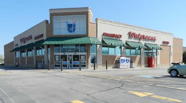
Property Record
505 W Raab Rd, Normal, IL 61761

Property Detail
505 W Raab Rd
14-21-128-032
BRADFORD-RAAB SUB LOT 1
Commercialnec
McLean
B-1
Illinois
B and X Area of moderate flood hazard, usually the area between the limits of the 100-year and 500-year floods.
1
2022
1.51 AC
2024
Bloomington/Normal
000107
Other Market Areas
14,705 SF
Bloomington, IL
NEARBY LISTINGS FOR SALE OR LEASE
DEMOGRAPHICS near 505 W Raab Rd
1 mile
3 mile
5 mile
2025 Total Population
10,277
54,904
109,814
2030 Population
10,386
54,948
110,048
Pop Growth 2025-2030
+ 1.06%
+ 0.08%
+ 0.21%
Average Age
34
34
37
2025 Total Households
3,999
21,007
44,816
HH Growth 2025-2030
+ 1.08%
(0.02%)
+ 0.22%
Median Household Inc
$62,911
$63,178
$68,075
Avg Household Size
2.20
2.20
2.20
2025 Avg HH Vehicles
2.00
2.00
2.00
Median Home Value
$199,574
$199,012
$200,724
Median Year Built
1988
1983
1977
Nearby Places
Map Layers
Map Styles
 Street
 Aerial
Layers
 Traffic
 Biking
Places
Listings with unknown addresses are not visible on the map
- Restaurants
- Banks
- Shops
- Fitness
- Groceries
PUBLIC TRANSPORTATION
COMMUTER RAIL
Drive
Walk
Distance
5 min
2.3 mi
AIRPORT
Central Il Regional/Bloomington-Normal
Drive
Walk
Distance
Central Il Regional/Bloomington-Normal
18 min
7.6 mi
SALE & LEASE HISTORY
LISTING DATE
SALE/LEASE

Jan 19, 2022
For Sale
Nearby Properties
Address
Land Use
TOTAL SIZE
Lot Size
Zoning
Address
Land Use
TOTAL SIZE
Lot Size
Zoning
65.47 AC
Address
Land Use
TOTAL SIZE
Lot Size
Zoning
154,502 SF
1.25 AC
Address
Land Use
TOTAL SIZE
Lot Size
Zoning
493,944 SF
2.95 AC
R-3A
Address
Land Use
TOTAL SIZE
Lot Size
Zoning
426,806 SF
20.93 AC
Address
Land Use
TOTAL SIZE
Lot Size
Zoning
127,569 SF
1.54 AC
Address
Land Use
TOTAL SIZE
Lot Size
Zoning
158,508 SF
3.13 AC
R1C
Address
Land Use
TOTAL SIZE
Lot Size
Zoning
126,418 SF
1.06 AC
Address
Land Use
TOTAL SIZE
Lot Size
Zoning
123,016 SF
18.52 AC
C-2
Address
Land Use
TOTAL SIZE
Lot Size
Zoning
513,218 SF
20.64 AC
R-3A
Address
Land Use
TOTAL SIZE
Lot Size
Zoning
10.13 AC
R2
Address
Land Use
TOTAL SIZE
Lot Size
Zoning
136,382 SF
9.53 AC
Address
Land Use
TOTAL SIZE
Lot Size
Zoning
423,526 SF
25.35 AC
B-1
Address
Land Use
TOTAL SIZE
Lot Size
Zoning
208,876 SF
20.87 AC
B-1
Address
Land Use
TOTAL SIZE
Lot Size
Zoning
309,750 SF
9.85 AC
R-3A
Address
Land Use
TOTAL SIZE
Lot Size
Zoning
351,360 SF
8.40 AC
R-3A
Address
Land Use
TOTAL SIZE
Lot Size
Zoning
122,112 SF
7.16 AC
Address
Land Use
TOTAL SIZE
Lot Size
Zoning
191,880 SF
3 AC
B-1
Address
Land Use
TOTAL SIZE
Lot Size
Zoning
281,134 SF
8.04 AC
R-3A
Address
Land Use
TOTAL SIZE
Lot Size
Zoning
86,950 SF
4 AC
B-1
Address
Land Use
TOTAL SIZE
Lot Size
Zoning
98,646 SF
4 AC
B-1
Address
Land Use
TOTAL SIZE
Lot Size
Zoning
83.87 AC
Address
Land Use
TOTAL SIZE
Lot Size
Zoning
28.92 AC
Address
Land Use
TOTAL SIZE
Lot Size
Zoning
3.82 AC
B-1
Address
Land Use
TOTAL SIZE
Lot Size
Zoning
139,324 SF
15.78 AC
B-1
Address
Land Use
TOTAL SIZE
Lot Size
Zoning
127,720 SF
1.68 AC
R-1C
Address
Land Use
TOTAL SIZE
Lot Size
Zoning
62,551 SF
0.42 AC
B-2
Address
Land Use
TOTAL SIZE
Lot Size
Zoning
84,278 SF
0.36 AC
B-2
Address
Land Use
TOTAL SIZE
Lot Size
Zoning
51,320 SF
0.70 AC
B-1
The World's #1 Commercial Real Estate Marketplace
Connect with us
© 2026 CoStar Group
The information above has been obtained from sources believed reliable. While we do not doubt its accuracy we have not verified it and make no guarantee, warranty or representation about it. It is your responsibility to independently confirm its accuracy and completeness. Any projections, opinions, assumptions, or estimates used are for example only and do not represent the current or future performance of the property. The value of this transaction to you depends on tax and other factors which should be evaluated by your tax, financial, and legal advisors. You and your advisors should conduct a careful, independent investigation of the property to determine to your satisfaction the suitability of the property for your needs.