Property Record
5050 Durham Rd, Roxboro, NC 27574


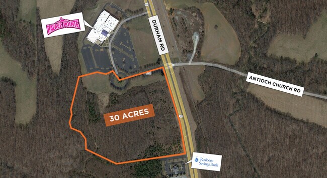

Property Detail
5050 Durham Rd
A51-155
17.44 ACRES/PALACE POINTE
Stripcommercialcenter
PERSON
B and X Area of moderate flood hazard, usually the area between the limits of the 100-year and 500-year floods.
North Carolina
2025
17.44 AC
2025
Person County
920601
Raleigh/Durham
89,169 SF
Durham-Chapel Hill, NC
NEARBY LISTINGS FOR SALE OR LEASE
DEMOGRAPHICS near 5050 Durham Rd
1 mile
3 mile
5 mile
2025 Total Population
224
4,359
13,654
2030 Population
228
4,475
14,046
Pop Growth 2025-2030
+ 1.79%
+ 2.66%
+ 2.87%
Average Age
42
42
42
2025 Total Households
89
1,775
5,618
HH Growth 2025-2030
+ 2.25%
+ 2.70%
+ 2.88%
Median Household Inc
$49,499
$60,689
$63,364
Avg Household Size
2.50
2.40
2.40
2025 Avg HH Vehicles
2.00
2.00
2.00
Median Home Value
$215,789
$202,332
$219,219
Median Year Built
1993
1991
1989
Nearby Places
Map Layers
Map Styles
 Street
 Aerial
Layers
 Traffic
 Biking
Places
Listings with unknown addresses are not visible on the map
- Restaurants
- Banks
- Shops
- Fitness
- Groceries
SALE & LEASE HISTORY
LISTING DATE
SALE/LEASE

Sep 24, 2016
For Sale
Nearby Properties
Address
Land Use
TOTAL SIZE
Lot Size
Zoning
Address
Land Use
TOTAL SIZE
Lot Size
Zoning
173,834 SF
76.41 AC
Address
Land Use
TOTAL SIZE
Lot Size
Zoning
70,600 SF
27.82 AC
Address
Land Use
TOTAL SIZE
Lot Size
Zoning
18,240 SF
394.60 AC
Address
Land Use
TOTAL SIZE
Lot Size
Zoning
78,099 SF
41.89 AC
Address
Land Use
TOTAL SIZE
Lot Size
Zoning
27,080 SF
3 AC
Address
Land Use
TOTAL SIZE
Lot Size
Zoning
289,445 SF
40.62 AC
Address
Land Use
TOTAL SIZE
Lot Size
Zoning
72,888 SF
10.51 AC
Address
Land Use
TOTAL SIZE
Lot Size
Zoning
84,000 SF
31.77 AC
Address
Land Use
TOTAL SIZE
Lot Size
Zoning
31,600 SF
11.50 AC
Address
Land Use
TOTAL SIZE
Lot Size
Zoning
75,000 SF
8.48 AC
Address
Land Use
TOTAL SIZE
Lot Size
Zoning
86,400 SF
16.40 AC
Address
Land Use
TOTAL SIZE
Lot Size
Zoning
14,486 SF
9.14 AC
Address
Land Use
TOTAL SIZE
Lot Size
Zoning
67,620 SF
21.65 AC
Address
Land Use
TOTAL SIZE
Lot Size
Zoning
31.85 AC
Address
Land Use
TOTAL SIZE
Lot Size
Zoning
45.31 AC
Address
Land Use
TOTAL SIZE
Lot Size
Zoning
1,784 SF
7.18 AC
Address
Land Use
TOTAL SIZE
Lot Size
Zoning
9,378 SF
2.39 AC
Address
Land Use
TOTAL SIZE
Lot Size
Zoning
4,448 SF
1.90 AC
Address
Land Use
TOTAL SIZE
Lot Size
Zoning
6,652 SF
3.54 AC
Address
Land Use
TOTAL SIZE
Lot Size
Zoning
63,934 SF
6.88 AC
Address
Land Use
TOTAL SIZE
Lot Size
Zoning
18.30 AC
Address
Land Use
TOTAL SIZE
Lot Size
Zoning
28.26 AC
Address
Land Use
TOTAL SIZE
Lot Size
Zoning
5,708 SF
22.80 AC
Address
Land Use
TOTAL SIZE
Lot Size
Zoning
7,914 SF
6.31 AC
Address
Land Use
TOTAL SIZE
Lot Size
Zoning
18,488 SF
1.50 AC
Address
Land Use
TOTAL SIZE
Lot Size
Zoning
5,986 SF
13.89 AC
Address
Land Use
TOTAL SIZE
Lot Size
Zoning
4,634 SF
2.72 AC
Address
Land Use
TOTAL SIZE
Lot Size
Zoning
10,460 SF
9.54 AC
Address
Land Use
TOTAL SIZE
Lot Size
Zoning
47,342 SF
12 AC
The World's #1 Commercial Real Estate Marketplace
Connect with us
© 2026 CoStar Group
The information above has been obtained from sources believed reliable. While we do not doubt its accuracy we have not verified it and make no guarantee, warranty or representation about it. It is your responsibility to independently confirm its accuracy and completeness. Any projections, opinions, assumptions, or estimates used are for example only and do not represent the current or future performance of the property. The value of this transaction to you depends on tax and other factors which should be evaluated by your tax, financial, and legal advisors. You and your advisors should conduct a careful, independent investigation of the property to determine to your satisfaction the suitability of the property for your needs.