Property Record
5050 E State Highway 29, Georgetown, TX 78626


Save to a Folder
{{folder.Name}}
{{folder.ListingIds.length}} Properties
{{folder.ListingIds.length}} Property
Create a New Folder
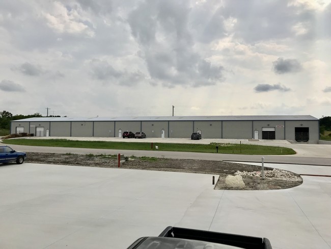
Property Detail
5050 E State Highway 29
Austin-Round Rock-San Marcos, TX
S11390 - SH29E PARK SUB, LOT 3, ACRES 3.01
R557971
Williamson
Commercialnec
Texas
B and X Area of moderate flood hazard, usually the area between the limits of the 100-year and 500-year floods.
3
2025
3.01 AC
2025
Georgetown
020822
Austin
19,932 SF
NEARBY LISTINGS FOR SALE OR LEASE
-
-
View all Georgetown listings for lease on LoopNet.com
DEMOGRAPHICS near 5050 E State Highway 29
1 mile
3 mile
5 mile
2025 Total Population
604
17,352
59,118
2030 Population
712
20,228
68,862
Pop Growth 2025-2030
+ 17.88%
+ 16.57%
+ 16.48%
Average Age
39
38
37
2025 Total Households
230
6,023
21,331
HH Growth 2025-2030
+ 18.26%
+ 17.22%
+ 17.07%
Median Household Inc
$87,884
$104,436
$96,522
Avg Household Size
2.50
2.80
2.60
2025 Avg HH Vehicles
2.00
2.00
2.00
Median Home Value
$308,750
$387,673
$413,778
Median Year Built
2010
2009
2010
Nearby Places
Map Layers
Map Styles
 Street
 Aerial
Layers
 Traffic
 Biking
Places
Listings with unknown addresses are not visible on the map
- Restaurants
- Banks
- Shops
- Fitness
- Groceries
PUBLIC TRANSPORTATION
AIRPORT
Austin-Bergstrom International
Drive
Walk
Distance
Austin-Bergstrom International
49 min
41.3 mi
Killeen Municipal
Drive
Walk
Distance
Killeen Municipal
52 min
42.3 mi
Robert Gray AAF
Drive
Walk
Distance
Robert Gray AAF
56 min
43.5 mi
SALE & LEASE HISTORY
LISTING DATE
SALE/LEASE

Nov 30, 2022
For Lease
Jun 10, 2019
For Sale
Jun 08, 2026
For Lease
Nearby Properties
Address
Land Use
TOTAL SIZE
Lot Size
Zoning
Address
Land Use
TOTAL SIZE
Lot Size
Zoning
228,685 SF
10.32 AC
Address
Land Use
TOTAL SIZE
Lot Size
Zoning
252,492 SF
15.35 AC
Address
Land Use
TOTAL SIZE
Lot Size
Zoning
49.39 AC
Address
Land Use
TOTAL SIZE
Lot Size
Zoning
116,641 SF
5.93 AC
Address
Land Use
TOTAL SIZE
Lot Size
Zoning
27.61 AC
Address
Land Use
TOTAL SIZE
Lot Size
Zoning
131.22 AC
Address
Land Use
TOTAL SIZE
Lot Size
Zoning
87,071 SF
60.32 AC
Address
Land Use
TOTAL SIZE
Lot Size
Zoning
182,592 SF
11.20 AC
Address
Land Use
TOTAL SIZE
Lot Size
Zoning
2,400 SF
56.17 AC
Address
Land Use
TOTAL SIZE
Lot Size
Zoning
39.97 AC
Address
Land Use
TOTAL SIZE
Lot Size
Zoning
98,099 SF
5.13 AC
Address
Land Use
TOTAL SIZE
Lot Size
Zoning
111 SF
54.28 AC
Address
Land Use
TOTAL SIZE
Lot Size
Zoning
82.14 AC
Address
Land Use
TOTAL SIZE
Lot Size
Zoning
63,232 SF
15 AC
Address
Land Use
TOTAL SIZE
Lot Size
Zoning
25.57 AC
Address
Land Use
TOTAL SIZE
Lot Size
Zoning
120,582 SF
3.36 AC
Address
Land Use
TOTAL SIZE
Lot Size
Zoning
76,433 SF
4.50 AC
Address
Land Use
TOTAL SIZE
Lot Size
Zoning
82,484 SF
7.32 AC
Address
Land Use
TOTAL SIZE
Lot Size
Zoning
3,489 SF
11.16 AC
Address
Land Use
TOTAL SIZE
Lot Size
Zoning
130.98 AC
Address
Land Use
TOTAL SIZE
Lot Size
Zoning
34,780 SF
9.79 AC
Address
Land Use
TOTAL SIZE
Lot Size
Zoning
53,794 SF
19.77 AC
Address
Land Use
TOTAL SIZE
Lot Size
Zoning
36,000 SF
2.46 AC
Address
Land Use
TOTAL SIZE
Lot Size
Zoning
864 SF
33.25 AC
Address
Land Use
TOTAL SIZE
Lot Size
Zoning
2,881 SF
5.61 AC
1-RS
Address
Land Use
TOTAL SIZE
Lot Size
Zoning
19,292 SF
8.32 AC
Address
Land Use
TOTAL SIZE
Lot Size
Zoning
12,431 SF
4.02 AC
Address
Land Use
TOTAL SIZE
Lot Size
Zoning
16,877 SF
2.43 AC
3-C-3
Address
Land Use
TOTAL SIZE
Lot Size
Zoning
34,834 SF
9.81 AC
Address
Land Use
TOTAL SIZE
Lot Size
Zoning
35,071 SF
15.30 AC
The World's #1 Commercial Real Estate Marketplace
Connect with us
© 2026 CoStar Group
The information above has been obtained from sources believed reliable. While we do not doubt its accuracy we have not verified it and make no guarantee, warranty or representation about it. It is your responsibility to independently confirm its accuracy and completeness. Any projections, opinions, assumptions, or estimates used are for example only and do not represent the current or future performance of the property. The value of this transaction to you depends on tax and other factors which should be evaluated by your tax, financial, and legal advisors. You and your advisors should conduct a careful, independent investigation of the property to determine to your satisfaction the suitability of the property for your needs.