Property Record
5050 Wesley Rd, Apopka, FL 32712

Save to a Folder
{{folder.Name}}
{{folder.ListingIds.length}} Properties
{{folder.ListingIds.length}} Property
Create a New Folder
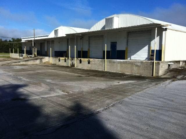
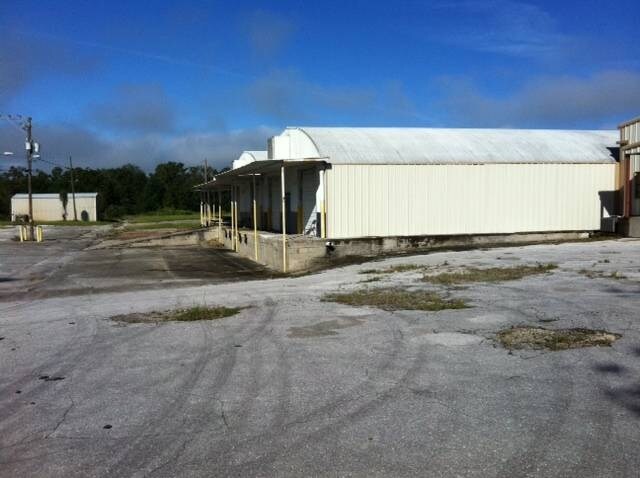
Property Detail
5050 Wesley Rd
27-2027-0000-00-052
E 316.77 FT OF THE N 15 FT OF THE NW1/4 OF THE SW1/4 OF THE SW1/4 OF SEC 26-20-27
Warehouse
ORANGE
PD
Florida
B and X Area of moderate flood hazard, usually the area between the limits of the 100-year and 500-year floods.
27
2025
90.98 AC
2026
NW Orange County
017901
Orlando
1,245,063 SF
Orlando-Kissimmee-Sanford, FL
NEARBY LISTINGS FOR SALE OR LEASE
DEMOGRAPHICS near 5050 Wesley Rd
1 mile
3 mile
5 mile
2025 Total Population
645
12,013
50,526
2030 Population
716
13,505
56,066
Pop Growth 2025-2030
+ 11.01%
+ 12.42%
+ 10.96%
Average Age
58
46
42
2025 Total Households
321
4,604
17,673
HH Growth 2025-2030
+ 10.90%
+ 12.45%
+ 11.29%
Median Household Inc
$66,627
$95,819
$108,449
Avg Household Size
2.00
2.60
2.80
2025 Avg HH Vehicles
2.00
2.00
2.00
Median Home Value
$181,817
$401,399
$444,009
Median Year Built
1989
1997
2002
Nearby Places
Map Layers
Map Styles
 Street
 Aerial
Layers
 Traffic
 Biking
Places
Listings with unknown addresses are not visible on the map
- Restaurants
- Banks
- Shops
- Fitness
- Groceries
PUBLIC TRANSPORTATION
AIRPORT
Orlando Sanford International
Drive
Walk
Distance
Orlando Sanford International
48 min
31.7 mi
Orlando International
Drive
Walk
Distance
Orlando International
47 min
35.8 mi
Nearby Properties
Address
Land Use
TOTAL SIZE
Lot Size
Zoning
Address
Land Use
TOTAL SIZE
Lot Size
Zoning
1,208,666 SF
57.24 AC
PD
Address
Land Use
TOTAL SIZE
Lot Size
Zoning
722,019 SF
35.47 AC
PD
Address
Land Use
TOTAL SIZE
Lot Size
Zoning
546,848 SF
33.62 AC
D-APK-PD
Address
Land Use
TOTAL SIZE
Lot Size
Zoning
588,076 SF
38.89 AC
PD
Address
Land Use
TOTAL SIZE
Lot Size
Zoning
347,706 SF
20.10 AC
PD
Address
Land Use
TOTAL SIZE
Lot Size
Zoning
323,161 SF
43.55 AC
PD
Address
Land Use
TOTAL SIZE
Lot Size
Zoning
283,364 SF
17.99 AC
D-APK-PD
Address
Land Use
TOTAL SIZE
Lot Size
Zoning
589,600 SF
19.60 AC
I-L
Address
Land Use
TOTAL SIZE
Lot Size
Zoning
267,044 SF
17.05 AC
D-APK-I-L
Address
Land Use
TOTAL SIZE
Lot Size
Zoning
255,880 SF
15.73 AC
PD
Address
Land Use
TOTAL SIZE
Lot Size
Zoning
133,960 SF
17.21 AC
PD
Address
Land Use
TOTAL SIZE
Lot Size
Zoning
82 AC
D-APK-MU-K
Address
Land Use
TOTAL SIZE
Lot Size
Zoning
685,777 SF
19.32 AC
I-L
Address
Land Use
TOTAL SIZE
Lot Size
Zoning
207,423 SF
10.76 AC
D-APK-PD
Address
Land Use
TOTAL SIZE
Lot Size
Zoning
207,428 SF
10.78 AC
D-APK-PD
Address
Land Use
TOTAL SIZE
Lot Size
Zoning
49 AC
D-APK-MU-V
Address
Land Use
TOTAL SIZE
Lot Size
Zoning
42 AC
D-APK-MU-V
Address
Land Use
TOTAL SIZE
Lot Size
Zoning
23 AC
U-ORG-P-D
Address
Land Use
TOTAL SIZE
Lot Size
Zoning
110,332 SF
13.52 AC
IND-4
Address
Land Use
TOTAL SIZE
Lot Size
Zoning
92,579 SF
5.86 AC
RSTD IND-2
Address
Land Use
TOTAL SIZE
Lot Size
Zoning
121,723 SF
8.41 AC
T
Address
Land Use
TOTAL SIZE
Lot Size
Zoning
9,318 SF
8.51 AC
A-1
Address
Land Use
TOTAL SIZE
Lot Size
Zoning
162,920 SF
15.05 AC
R-CE
Address
Land Use
TOTAL SIZE
Lot Size
Zoning
98,625 SF
4.71 AC
C-C
Address
Land Use
TOTAL SIZE
Lot Size
Zoning
251,616 SF
36.99 AC
A-1
Address
Land Use
TOTAL SIZE
Lot Size
Zoning
52,695 SF
57.69 AC
I-L
Address
Land Use
TOTAL SIZE
Lot Size
Zoning
41,268 SF
7.37 AC
I-L
Address
Land Use
TOTAL SIZE
Lot Size
Zoning
117,023 SF
4.62 AC
I-L
Address
Land Use
TOTAL SIZE
Lot Size
Zoning
28.25 AC
PUD
The World's #1 Commercial Real Estate Marketplace
Connect with us
© 2026 CoStar Group
The information above has been obtained from sources believed reliable. While we do not doubt its accuracy we have not verified it and make no guarantee, warranty or representation about it. It is your responsibility to independently confirm its accuracy and completeness. Any projections, opinions, assumptions, or estimates used are for example only and do not represent the current or future performance of the property. The value of this transaction to you depends on tax and other factors which should be evaluated by your tax, financial, and legal advisors. You and your advisors should conduct a careful, independent investigation of the property to determine to your satisfaction the suitability of the property for your needs.