Property Record
5053 Clayridge Dr, Saint Louis, MO 63129
NEARBY LISTINGS FOR SALE OR LEASE
Property Detail
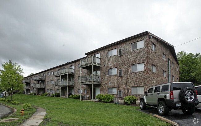
5053 Clayridge Dr
30K-12-0116
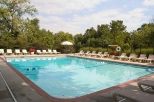
Lemay Ferry Apartments Pt
Apartment
LEMAY FERRY APARTMENTS PT (TERM 13879 2110)
X
St. Louis
17133C0075F
Missouri
2024
7.40 AC
2025
Mehlville
221338
St. Louis
126,210 SF
St. Louis, MO-IL
DEMOGRAPHICS near 5053 Clayridge Dr
1 Mile
3 Mile
5 Mile
2024 Total Population
10,380
72,634
168,448
2029 Population
10,117
71,041
165,781
Pop Growth 2024-2029
(2.53%)
(2.19%)
(1.58%)
Average Age
42
44
43
2024 Total Households
4,621
31,563
70,910
HH Growth 2024-2029
(2.51%)
(2.22%)
(1.62%)
Median Household Inc
$59,903
$73,263
$74,633
Avg Household Size
2.20
2.30
2.30
2024 Avg HH Vehicles
2.00
2.00
2.00
Median Home Value
$257,008
$251,181
$236,238
Median Year Built
1977
1975
1971
Nearby Places
- Restaurants
- Banks
- Shops
- Fitness
- Groceries
PUBLIC TRANSPORTATION
COMMUTER RAIL
Shrewsbury-Lansdowne (Shrewsbury-Lansdowne I-44 Emerson Park - St. Louis MetroLink (MetroLink))
DRIVE
WALK
Distance
Shrewsbury-Lansdowne (Shrewsbury-Lansdowne I-44 Emerson Park - St. Louis MetroLink (MetroLink))
17 min
9.5 mi
AIRPORT
St Louis Lambert International
DRIVE
WALK
Distance
St Louis Lambert International
37 min
23.1 mi
Scott AFB/Midamerica St Louis
DRIVE
WALK
Distance
Scott AFB/Midamerica St Louis
55 min
39.2 mi
Freight Ports
Tulsa Port of Inola
DRIVE
WALK
Distance
Tulsa Port of Inola
416 min
377.2 mi
Nearby Properties
Address
Land Use
TOTAL SIZE
Lot Size
Zoning
Address
Land Use
TOTAL SIZE
Lot Size
Zoning
31.45 AC
Address
Land Use
TOTAL SIZE
Lot Size
Zoning
31.42 AC
R2
Address
Land Use
TOTAL SIZE
Lot Size
Zoning
93,822 SF
33.97 AC
C-8
Address
Land Use
TOTAL SIZE
Lot Size
Zoning
739,781 SF
22.08 AC
C3
Address
Land Use
TOTAL SIZE
Lot Size
Zoning
31.25 AC
R2
Address
Land Use
TOTAL SIZE
Lot Size
Zoning
40.60 AC
R4
Address
Land Use
TOTAL SIZE
Lot Size
Zoning
225,758 SF
16.85 AC
R4
Address
Land Use
TOTAL SIZE
Lot Size
Zoning
140,783 SF
15.51 AC
C-8
Address
Land Use
TOTAL SIZE
Lot Size
Zoning
342,288 SF
19.97 AC
R7
Address
Land Use
TOTAL SIZE
Lot Size
Zoning
26.62 AC
R3
Address
Land Use
TOTAL SIZE
Lot Size
Zoning
113,971 SF
6.64 AC
C-8
Address
Land Use
TOTAL SIZE
Lot Size
Zoning
103,204 SF
1.47 AC
C-8
Address
Land Use
TOTAL SIZE
Lot Size
Zoning
117,399 SF
0.81 AC
Address
Land Use
TOTAL SIZE
Lot Size
Zoning
237,114 SF
18.12 AC
M1
Address
Land Use
TOTAL SIZE
Lot Size
Zoning
142,800 SF
13.38 AC
106PL1
Address
Land Use
TOTAL SIZE
Lot Size
Zoning
21.55 AC
C-8
Address
Land Use
TOTAL SIZE
Lot Size
Zoning
386,377 SF
21.34 AC
R7
Address
Land Use
TOTAL SIZE
Lot Size
Zoning
1,800 SF
116.73 AC
PS
Address
Land Use
TOTAL SIZE
Lot Size
Zoning
163,144 SF
14.14 AC
C-8
Address
Land Use
TOTAL SIZE
Lot Size
Zoning
98,008 SF
10.19 AC
C-8
Address
Land Use
TOTAL SIZE
Lot Size
Zoning
499,003 SF
99.34 AC
C-8
Address
Land Use
TOTAL SIZE
Lot Size
Zoning
114,707 SF
10.94 AC
C-8
Address
Land Use
TOTAL SIZE
Lot Size
Zoning
1,268 SF
19.85 AC
R2
Address
Land Use
TOTAL SIZE
Lot Size
Zoning
143,076 SF
18.99 AC
C-8
Address
Land Use
TOTAL SIZE
Lot Size
Zoning
127,090 SF
11.28 AC
C-8
Address
Land Use
TOTAL SIZE
Lot Size
Zoning
119,473 SF
8.65 AC
106PL1
Address
Land Use
TOTAL SIZE
Lot Size
Zoning
12.37 AC
R4
Address
Land Use
TOTAL SIZE
Lot Size
Zoning
188,205 SF
14.86 AC
R2
Address
Land Use
TOTAL SIZE
Lot Size
Zoning
205,040 SF
13.93 AC
M
Address
Land Use
TOTAL SIZE
Lot Size
Zoning
58,287 SF
18.90 AC
NU
The World's #1 Commercial Real Estate Marketplace
Connect with us
© 2025 CoStar Group
The information above has been obtained from sources believed reliable. While we do not doubt its accuracy we have not verified it and make no guarantee, warranty or representation about it. It is your responsibility to independently confirm its accuracy and completeness. Any projections, opinions, assumptions, or estimates used are for example only and do not represent the current or future performance of the property. The value of this transaction to you depends on tax and other factors which should be evaluated by your tax, financial, and legal advisors. You and your advisors should conduct a careful, independent investigation of the property to determine to your satisfaction the suitability of the property for your needs.