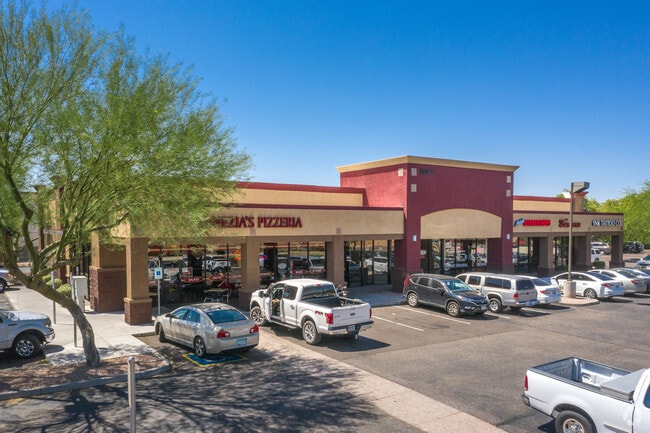
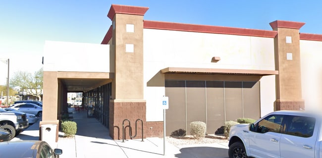
Property Record
5057 E Mckellips Rd, Mesa, AZ 85215


Current Lease Availabilities
Property Detail
5057 E Mckellips Rd
141-35-016H
MESA INTERNATIONAL BUSINESS CENTER UNIT 1 1-12 A MCR 320-15
Storebuilding
Maricopa
I-1
Arizona
C and X Area of minimal flood hazard, usually depicted on FIRMs as above the 500-year flood level.
11
2025
1.24 AC
2025
Red Mountain/Mesa
420215
Phoenix
8,320 SF
Phoenix-Mesa-Chandler, AZ
NEARBY LISTINGS FOR SALE OR LEASE
DEMOGRAPHICS near 5057 E Mckellips Rd
1 mile
3 mile
5 mile
2025 Total Population
8,921
84,316
223,156
2030 Population
9,403
87,955
233,116
Pop Growth 2025-2030
+ 5.40%
+ 4.32%
+ 4.46%
Average Age
48
46
45
2025 Total Households
4,029
35,461
91,138
HH Growth 2025-2030
+ 5.91%
+ 4.86%
+ 4.90%
Median Household Inc
$75,560
$82,566
$81,786
Avg Household Size
2.20
2.30
2.40
2025 Avg HH Vehicles
2.00
2.00
2.00
Median Home Value
$438,400
$409,199
$413,709
Median Year Built
1989
1988
1988
Nearby Places
Map Layers
Map Styles
 Street
 Aerial
Transit
 Traffic
 Biking
Places
Listings with unknown addresses are not visible on the map
- Restaurants
- Banks
- Shops
- Fitness
- Groceries
PUBLIC TRANSPORTATION
AIRPORT
Phoenix-Mesa Gateway
Drive
Walk
Distance
Phoenix-Mesa Gateway
25 min
13.5 mi
Phoenix Sky Harbor International
Drive
Walk
Distance
Phoenix Sky Harbor International
28 min
17.2 mi
Nearby Properties
Address
Land Use
TOTAL SIZE
Lot Size
Zoning
Address
Land Use
TOTAL SIZE
Lot Size
Zoning
181.80 AC
Address
Land Use
TOTAL SIZE
Lot Size
Zoning
125,356 SF
21.63 AC
R-9
Address
Land Use
TOTAL SIZE
Lot Size
Zoning
53,910 SF
4.98 AC
C-G
Address
Land Use
TOTAL SIZE
Lot Size
Zoning
1,691,248 SF
528.80 AC
I-1
Address
Land Use
TOTAL SIZE
Lot Size
Zoning
29.74 AC
Address
Land Use
TOTAL SIZE
Lot Size
Zoning
22.19 AC
Address
Land Use
TOTAL SIZE
Lot Size
Zoning
1,217,466 SF
102.41 AC
I-1
Address
Land Use
TOTAL SIZE
Lot Size
Zoning
22.71 AC
Address
Land Use
TOTAL SIZE
Lot Size
Zoning
324,534 SF
50.86 AC
PF
Address
Land Use
TOTAL SIZE
Lot Size
Zoning
271,098 SF
142.75 AC
PF
Address
Land Use
TOTAL SIZE
Lot Size
Zoning
161,388 SF
32.52 AC
R-35
Address
Land Use
TOTAL SIZE
Lot Size
Zoning
279,338 SF
39.90 AC
PF
Address
Land Use
TOTAL SIZE
Lot Size
Zoning
122,042 SF
15.79 AC
PF
Address
Land Use
TOTAL SIZE
Lot Size
Zoning
242,794 SF
14.29 AC
PEP
Address
Land Use
TOTAL SIZE
Lot Size
Zoning
140,141 SF
37.70 AC
PF
Address
Land Use
TOTAL SIZE
Lot Size
Zoning
66,350 SF
22.32 AC
I-1
Address
Land Use
TOTAL SIZE
Lot Size
Zoning
158,514 SF
21.39 AC
Address
Land Use
TOTAL SIZE
Lot Size
Zoning
8.82 AC
Address
Land Use
TOTAL SIZE
Lot Size
Zoning
349,318 SF
18.47 AC
M-H
Address
Land Use
TOTAL SIZE
Lot Size
Zoning
359,204 SF
40.94 AC
LI
Address
Land Use
TOTAL SIZE
Lot Size
Zoning
7.90 AC
Address
Land Use
TOTAL SIZE
Lot Size
Zoning
214,197 SF
10.43 AC
RM3
Address
Land Use
TOTAL SIZE
Lot Size
Zoning
187,297 SF
3.99 AC
R-9
Address
Land Use
TOTAL SIZE
Lot Size
Zoning
4.79 AC
Address
Land Use
TOTAL SIZE
Lot Size
Zoning
7.26 AC
Address
Land Use
TOTAL SIZE
Lot Size
Zoning
3,545 SF
1.14 AC
C-G
Address
Land Use
TOTAL SIZE
Lot Size
Zoning
225,233 SF
21.66 AC
C-G
Address
Land Use
TOTAL SIZE
Lot Size
Zoning
125,534 SF
19.59 AC
I-2
Address
Land Use
TOTAL SIZE
Lot Size
Zoning
81,000 SF
15.70 AC
AG
Address
Land Use
TOTAL SIZE
Lot Size
Zoning
343,128 SF
13.01 AC
M-H
The World's #1 Commercial Real Estate Marketplace
Connect with us
© 2026 CoStar Group
The information above has been obtained from sources believed reliable. While we do not doubt its accuracy we have not verified it and make no guarantee, warranty or representation about it. It is your responsibility to independently confirm its accuracy and completeness. Any projections, opinions, assumptions, or estimates used are for example only and do not represent the current or future performance of the property. The value of this transaction to you depends on tax and other factors which should be evaluated by your tax, financial, and legal advisors. You and your advisors should conduct a careful, independent investigation of the property to determine to your satisfaction the suitability of the property for your needs.