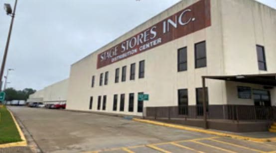
Property Record
506 Bealls Blvd, Jacksonville, TX 75766

NEARBY LISTINGS FOR SALE OR LEASE
-
-
No Photo
-
-
-
View all Jacksonville listings for sale on LoopNet.com
Property Detail
506 Bealls Blvd
000107962210
T Quevado Survey A-44
Industrialgeneral
A 44 BLK 3421 TR 7 T QUEVADO
X
Cherokee
48073C0285D
Texas
2025
27.55 AC
2025
Texas East Area
950600
Other Market Areas
566,000 SF
Jacksonville, TX
DEMOGRAPHICS near 506 Bealls Blvd
1 Mile
3 Mile
5 Mile
2024 Total Population
1,635
14,487
20,587
2029 Population
1,759
15,453
21,920
Pop Growth 2024-2029
+ 7.58%
+ 6.67%
+ 6.47%
Average Age
38
37
38
2024 Total Households
565
5,082
7,406
HH Growth 2024-2029
+ 7.79%
+ 6.83%
+ 6.66%
Median Household Inc
$24,900
$42,786
$45,795
Avg Household Size
2.90
2.80
2.70
2024 Avg HH Vehicles
2.00
2.00
2.00
Median Home Value
$69,999
$106,105
$124,325
Median Year Built
1971
1975
1978
Nearby Places
Map Layers
Map Styles
 Street
 Aerial
- Restaurants
- Banks
- Shops
- Fitness
- Groceries
PUBLIC TRANSPORTATION
AIRPORT
Tyler Pounds Regional
DRIVE
WALK
Distance
Tyler Pounds Regional
44 min
34.2 mi
Freight Ports
Port of Shreveport
DRIVE
WALK
Distance
Port of Shreveport
151 min
132.7 mi
SALE & LEASE HISTORY
LISTING DATE
SALE/LEASE

Jul 22, 2020
For Sale
Nearby Properties
Address
Land Use
TOTAL SIZE
Lot Size
Zoning
Address
Land Use
TOTAL SIZE
Lot Size
Zoning
240,478 SF
3.65 AC
Address
Land Use
TOTAL SIZE
Lot Size
Zoning
128,378 SF
8.85 AC
Address
Land Use
TOTAL SIZE
Lot Size
Zoning
271,920 SF
16.25 AC
Address
Land Use
TOTAL SIZE
Lot Size
Zoning
593,739 SF
23.67 AC
Address
Land Use
TOTAL SIZE
Lot Size
Zoning
132,402 SF
5.25 AC
Address
Land Use
TOTAL SIZE
Lot Size
Zoning
361,673 SF
9.16 AC
Address
Land Use
TOTAL SIZE
Lot Size
Zoning
42,150 SF
2.85 AC
Address
Land Use
TOTAL SIZE
Lot Size
Zoning
240,296 SF
6.45 AC
Address
Land Use
TOTAL SIZE
Lot Size
Zoning
37,556 SF
Address
Land Use
TOTAL SIZE
Lot Size
Zoning
78,238 SF
1.98 AC
Address
Land Use
TOTAL SIZE
Lot Size
Zoning
142,286 SF
35.67 AC
Address
Land Use
TOTAL SIZE
Lot Size
Zoning
225,000 SF
15.18 AC
Address
Land Use
TOTAL SIZE
Lot Size
Zoning
96,420 SF
1.32 AC
Address
Land Use
TOTAL SIZE
Lot Size
Zoning
83,091 SF
5.72 AC
Address
Land Use
TOTAL SIZE
Lot Size
Zoning
145,656 SF
3.75 AC
Address
Land Use
TOTAL SIZE
Lot Size
Zoning
17,875 SF
1.12 AC
Address
Land Use
TOTAL SIZE
Lot Size
Zoning
54,666 SF
1.54 AC
Address
Land Use
TOTAL SIZE
Lot Size
Zoning
87,834 SF
10.59 AC
Address
Land Use
TOTAL SIZE
Lot Size
Zoning
14,512 SF
0.52 AC
Address
Land Use
TOTAL SIZE
Lot Size
Zoning
92,203 SF
26.87 AC
Address
Land Use
TOTAL SIZE
Lot Size
Zoning
30,899 SF
0.85 AC
Address
Land Use
TOTAL SIZE
Lot Size
Zoning
17,310 SF
1.43 AC
Address
Land Use
TOTAL SIZE
Lot Size
Zoning
196,671 SF
5.36 AC
Address
Land Use
TOTAL SIZE
Lot Size
Zoning
110,360 SF
13.59 AC
Address
Land Use
TOTAL SIZE
Lot Size
Zoning
135,208 SF
0.66 AC
Address
Land Use
TOTAL SIZE
Lot Size
Zoning
63,582 SF
1.99 AC
Address
Land Use
TOTAL SIZE
Lot Size
Zoning
Address
Land Use
TOTAL SIZE
Lot Size
Zoning
93,754 SF
17.73 AC
Address
Land Use
TOTAL SIZE
Lot Size
Zoning
40,734 SF
0.85 AC
The World's #1 Commercial Real Estate Marketplace
Connect with us
© 2025 CoStar Group
The information above has been obtained from sources believed reliable. While we do not doubt its accuracy we have not verified it and make no guarantee, warranty or representation about it. It is your responsibility to independently confirm its accuracy and completeness. Any projections, opinions, assumptions, or estimates used are for example only and do not represent the current or future performance of the property. The value of this transaction to you depends on tax and other factors which should be evaluated by your tax, financial, and legal advisors. You and your advisors should conduct a careful, independent investigation of the property to determine to your satisfaction the suitability of the property for your needs.