Property Record
506 E Greeley St, Broken Arrow, OK 74012


NEARBY LISTINGS FOR SALE OR LEASE
-
-
View all Broken Arrow listings for sale on LoopNet.com
Property Detail
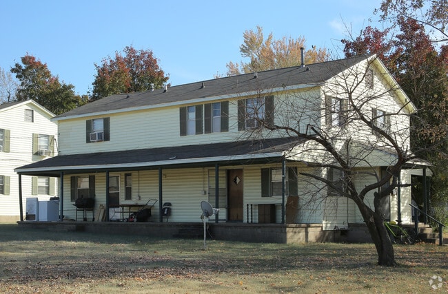
506 E Greeley St
Tulsa, OK
Lowerys Addn
80290-84-11-12980
PT LT 7 BEG SWC TH E197 N151 TH W TO WL SLY ON WL TO BEG LESS S30 FOR ST
Multifamilydwelling
Tulsa
X
Oklahoma
40143C0391L
7
2025
0.45 AC
2025
Downtown Broken Arrow
007402
Tulsa
5,352 SF
DEMOGRAPHICS near 506 E Greeley St
1 Mile
3 Mile
5 Mile
2024 Total Population
6,372
62,593
149,049
2029 Population
6,681
65,630
157,722
Pop Growth 2024-2029
+ 4.85%
+ 4.85%
+ 5.82%
Average Age
39
38
38
2024 Total Households
2,641
24,246
56,704
HH Growth 2024-2029
+ 4.92%
+ 4.95%
+ 5.70%
Median Household Inc
$52,256
$70,838
$71,588
Avg Household Size
2.30
2.50
2.60
2024 Avg HH Vehicles
2.00
2.00
2.00
Median Home Value
$164,285
$193,209
$196,950
Median Year Built
1975
1993
1992
Nearby Places
Map Layers
Map Styles
 Street
 Aerial
- Restaurants
- Banks
- Shops
- Fitness
- Groceries
PUBLIC TRANSPORTATION
AIRPORT
Tulsa International
DRIVE
WALK
Distance
Tulsa International
25 min
17.2 mi
Freight Ports
DRIVE
WALK
Distance
25 min
14.4 mi
Nearby Properties
Address
Land Use
TOTAL SIZE
Lot Size
Zoning
Address
Land Use
TOTAL SIZE
Lot Size
Zoning
197,676 SF
13.38 AC
CH
Address
Land Use
TOTAL SIZE
Lot Size
Zoning
435,822 SF
43.42 AC
R1
Address
Land Use
TOTAL SIZE
Lot Size
Zoning
115,003 SF
59.09 AC
CG
Address
Land Use
TOTAL SIZE
Lot Size
Zoning
125,902 SF
19.15 AC
CH
Address
Land Use
TOTAL SIZE
Lot Size
Zoning
59,108 SF
11.18 AC
R3
Address
Land Use
TOTAL SIZE
Lot Size
Zoning
53,139 SF
108.91 AC
A1
Address
Land Use
TOTAL SIZE
Lot Size
Zoning
84,927 SF
4.81 AC
RM2
Address
Land Use
TOTAL SIZE
Lot Size
Zoning
75,444 SF
23.92 AC
R1
Address
Land Use
TOTAL SIZE
Lot Size
Zoning
58,695 SF
5.34 AC
RM
Address
Land Use
TOTAL SIZE
Lot Size
Zoning
77,260 SF
0.58 AC
R3
Address
Land Use
TOTAL SIZE
Lot Size
Zoning
49,113 SF
5.42 AC
R3
Address
Land Use
TOTAL SIZE
Lot Size
Zoning
222,768 SF
20.24 AC
CS
Address
Land Use
TOTAL SIZE
Lot Size
Zoning
68,478 SF
9.27 AC
R1
Address
Land Use
TOTAL SIZE
Lot Size
Zoning
67,149 SF
28.56 AC
R2
Address
Land Use
TOTAL SIZE
Lot Size
Zoning
58,627 SF
6.07 AC
CG
Address
Land Use
TOTAL SIZE
Lot Size
Zoning
363,154 SF
23.09 AC
IL
Address
Land Use
TOTAL SIZE
Lot Size
Zoning
71,362 SF
14.08 AC
RD
Address
Land Use
TOTAL SIZE
Lot Size
Zoning
39,733 SF
9.36 AC
A1
Address
Land Use
TOTAL SIZE
Lot Size
Zoning
60,790 SF
10.84 AC
R1
Address
Land Use
TOTAL SIZE
Lot Size
Zoning
11,601 SF
38.18 AC
RS1
Address
Land Use
TOTAL SIZE
Lot Size
Zoning
248,722 SF
15.01 AC
RM
Address
Land Use
TOTAL SIZE
Lot Size
Zoning
268,496 SF
19.31 AC
CN
Address
Land Use
TOTAL SIZE
Lot Size
Zoning
36,408 SF
10.46 AC
IL
Address
Land Use
TOTAL SIZE
Lot Size
Zoning
239,868 SF
14.84 AC
CG
Address
Land Use
TOTAL SIZE
Lot Size
Zoning
13,691 SF
2.04 AC
CH
Address
Land Use
TOTAL SIZE
Lot Size
Zoning
14,056 SF
60.03 AC
A1
Address
Land Use
TOTAL SIZE
Lot Size
Zoning
24,000 SF
7.50 AC
R1
Address
Land Use
TOTAL SIZE
Lot Size
Zoning
8.25 AC
CH
Address
Land Use
TOTAL SIZE
Lot Size
Zoning
71,143 SF
4.43 AC
R1
Address
Land Use
TOTAL SIZE
Lot Size
Zoning
367,352 SF
17.83 AC
CG
The World's #1 Commercial Real Estate Marketplace
Connect with us
© 2026 CoStar Group
The information above has been obtained from sources believed reliable. While we do not doubt its accuracy we have not verified it and make no guarantee, warranty or representation about it. It is your responsibility to independently confirm its accuracy and completeness. Any projections, opinions, assumptions, or estimates used are for example only and do not represent the current or future performance of the property. The value of this transaction to you depends on tax and other factors which should be evaluated by your tax, financial, and legal advisors. You and your advisors should conduct a careful, independent investigation of the property to determine to your satisfaction the suitability of the property for your needs.