Property Record
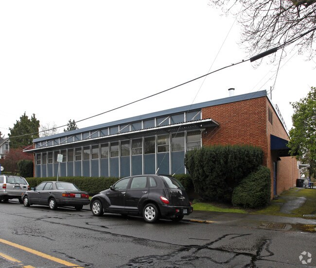
506 High St, Oregon City, OR 97045


Property Detail
506 High St
Portland-Vancouver-Hillsboro, OR-WA
2 OREGON CITY LTS 5&6 BLK 38
00573123
Clackamas
Commercialbuilding
Oregon
MUC1
5,6
B and X Area of moderate flood hazard, usually the area between the limits of the 100-year and 500-year floods.
0.32 AC
0
Oregon City
2025
Portland
022400
NEARBY LISTINGS FOR SALE OR LEASE
DEMOGRAPHICS near 506 High St
1 mile
3 mile
5 mile
2025 Total Population
10,391
78,542
135,302
2030 Population
10,413
78,583
135,155
Pop Growth 2025-2030
+ 0.21%
+ 0.05%
(0.11%)
Average Age
41
42
43
2025 Total Households
4,056
29,626
51,732
HH Growth 2025-2030
+ 0.17%
(0.01%)
(0.18%)
Median Household Inc
$99,059
$103,317
$103,908
Avg Household Size
2.50
2.60
2.50
2025 Avg HH Vehicles
2.00
2.00
2.00
Median Home Value
$593,109
$639,206
$645,047
Median Year Built
1970
1983
1979
Nearby Places
Map Layers
Map Styles
 Street
 Aerial
Layers
 Traffic
 Biking
Places
Listings with unknown addresses are not visible on the map
- Restaurants
- Banks
- Shops
- Fitness
- Groceries
PUBLIC TRANSPORTATION
COMMUTER RAIL
Drive
Walk
Distance
4 min
20 min
1.0 mi
AIRPORT
Portland International
Drive
Walk
Distance
Portland International
30 min
18.8 mi
Freight Ports
Port of Portland
Drive
Walk
Distance
Port of Portland
32 min
16.3 mi
Nearby Properties
Address
Land Use
TOTAL SIZE
Lot Size
Zoning
Address
Land Use
TOTAL SIZE
Lot Size
Zoning
58 AC
MUE
Address
Land Use
TOTAL SIZE
Lot Size
Zoning
15.26 AC
GI
Address
Land Use
TOTAL SIZE
Lot Size
Zoning
9,233 SF
8.27 AC
MUE
Address
Land Use
TOTAL SIZE
Lot Size
Zoning
20.28 AC
R2
Address
Land Use
TOTAL SIZE
Lot Size
Zoning
3.11 AC
GC
Address
Land Use
TOTAL SIZE
Lot Size
Zoning
1,008 SF
10 AC
R3
Address
Land Use
TOTAL SIZE
Lot Size
Zoning
2,482 SF
5.14 AC
MR
Address
Land Use
TOTAL SIZE
Lot Size
Zoning
6 AC
OBC
Address
Land Use
TOTAL SIZE
Lot Size
Zoning
936 SF
10.25 AC
CI
Address
Land Use
TOTAL SIZE
Lot Size
Zoning
11 AC
MUD
Address
Land Use
TOTAL SIZE
Lot Size
Zoning
16.49 AC
MUD
Address
Land Use
TOTAL SIZE
Lot Size
Zoning
9.30 AC
C
Address
Land Use
TOTAL SIZE
Lot Size
Zoning
70.97 AC
OP
Address
Land Use
TOTAL SIZE
Lot Size
Zoning
15.29 AC
R2
Address
Land Use
TOTAL SIZE
Lot Size
Zoning
3.18 AC
C3
Address
Land Use
TOTAL SIZE
Lot Size
Zoning
8.27 AC
MR
Address
Land Use
TOTAL SIZE
Lot Size
Zoning
Address
Land Use
TOTAL SIZE
Lot Size
Zoning
9.21 AC
R3
Address
Land Use
TOTAL SIZE
Lot Size
Zoning
6 AC
OP
Address
Land Use
TOTAL SIZE
Lot Size
Zoning
980 SF
6.19 AC
GC
Address
Land Use
TOTAL SIZE
Lot Size
Zoning
Address
Land Use
TOTAL SIZE
Lot Size
Zoning
4 AC
MUE
Address
Land Use
TOTAL SIZE
Lot Size
Zoning
6.16 AC
GC
Address
Land Use
TOTAL SIZE
Lot Size
Zoning
1,202 SF
3 AC
OBC
Address
Land Use
TOTAL SIZE
Lot Size
Zoning
6.14 AC
R2.1
Address
Land Use
TOTAL SIZE
Lot Size
Zoning
1.67 AC
MUE
Address
Land Use
TOTAL SIZE
Lot Size
Zoning
4.56 AC
MR
Address
Land Use
TOTAL SIZE
Lot Size
Zoning
9.07 AC
GI
Address
Land Use
TOTAL SIZE
Lot Size
Zoning
0.94 AC
MUD
Address
Land Use
TOTAL SIZE
Lot Size
Zoning
4.12 AC
MUC2
The World's #1 Commercial Real Estate Marketplace
Connect with us
© 2026 CoStar Group
The information above has been obtained from sources believed reliable. While we do not doubt its accuracy we have not verified it and make no guarantee, warranty or representation about it. It is your responsibility to independently confirm its accuracy and completeness. Any projections, opinions, assumptions, or estimates used are for example only and do not represent the current or future performance of the property. The value of this transaction to you depends on tax and other factors which should be evaluated by your tax, financial, and legal advisors. You and your advisors should conduct a careful, independent investigation of the property to determine to your satisfaction the suitability of the property for your needs.