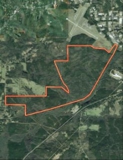
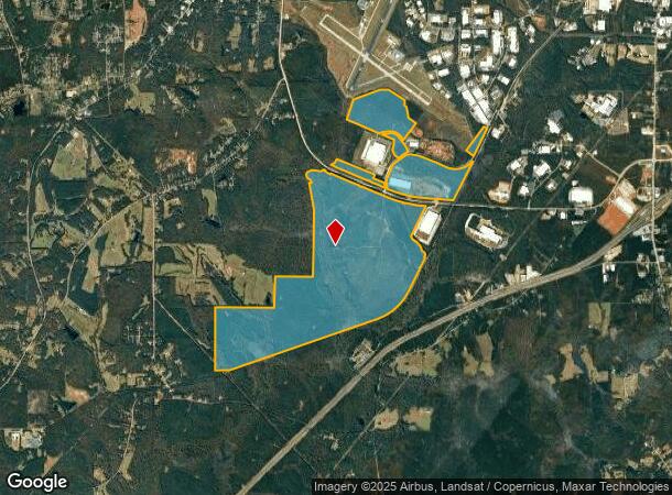
Property Record
615 Pegasus Pkwy, Lagrange, GA 30240
NEARBY LISTINGS FOR SALE OR LEASE
Property Detail
615 Pegasus Pkwy
LaGrange, GA
Callaway South Industrial Park
071-4-000-011
615 PEGASUS PKWY
Industrialacreage
Troup
AE
Georgia
13285C0230E
1,279.17 AC
2024
Troup County
2025
Columbus GA
960300
DEMOGRAPHICS near 615 Pegasus Pkwy
1 Mile
3 Mile
5 Mile
2024 Total Population
2
3,462
23,512
2029 Population
2
3,485
23,951
Pop Growth 2024-2029
0.00%
+ 0.66%
+ 1.87%
Average Age
0
40
39
2024 Total Households
1
1,340
8,833
HH Growth 2024-2029
0.00%
+ 0.67%
+ 1.97%
Median Household Inc
$0
$53,051
$47,882
Avg Household Size
.00
2.50
2.50
2024 Avg HH Vehicles
.00
2.00
2.00
Median Home Value
$0
$273,267
$171,120
Median Year Built
0
1990
1980
Nearby Places
Map Layers
Map Styles
 Street
 Aerial
- Restaurants
- Banks
- Shops
- Fitness
- Groceries
Nearby Properties
Address
Land Use
TOTAL SIZE
Lot Size
Zoning
Address
Land Use
TOTAL SIZE
Lot Size
Zoning
35,964 SF
72.39 AC
16- CP-GI
Address
Land Use
TOTAL SIZE
Lot Size
Zoning
334,378 SF
267.59 AC
16- CP-GI
Address
Land Use
TOTAL SIZE
Lot Size
Zoning
525,250 SF
45.33 AC
16- CP-GI
Address
Land Use
TOTAL SIZE
Lot Size
Zoning
95,472 SF
30.05 AC
16- CR-MR
Address
Land Use
TOTAL SIZE
Lot Size
Zoning
4,909 SF
731.14 AC
16- CP-GI
Address
Land Use
TOTAL SIZE
Lot Size
Zoning
275,130 SF
66.99 AC
16- CP-GI
Address
Land Use
TOTAL SIZE
Lot Size
Zoning
323,137 SF
34.65 AC
16- CP-GI
Address
Land Use
TOTAL SIZE
Lot Size
Zoning
162,803 SF
3.71 AC
16- CP-GI
Address
Land Use
TOTAL SIZE
Lot Size
Zoning
30,224 SF
19.82 AC
16- CP-GI
Address
Land Use
TOTAL SIZE
Lot Size
Zoning
484,700 SF
54.09 AC
16- CP-GI
Address
Land Use
TOTAL SIZE
Lot Size
Zoning
53,565 SF
26.06 AC
16- CP-GI
Address
Land Use
TOTAL SIZE
Lot Size
Zoning
151,088 SF
7.10 AC
16- CP-GI
Address
Land Use
TOTAL SIZE
Lot Size
Zoning
7,380 SF
126.31 AC
16- CP-GI
Address
Land Use
TOTAL SIZE
Lot Size
Zoning
24,412 SF
147.20 AC
16- CP-GI
Address
Land Use
TOTAL SIZE
Lot Size
Zoning
209,312 SF
26.56 AC
16- CP-GI
Address
Land Use
TOTAL SIZE
Lot Size
Zoning
97,903 SF
4.50 AC
16- CP-GI
Address
Land Use
TOTAL SIZE
Lot Size
Zoning
64,432 SF
81.09 AC
16- CP-GB
Address
Land Use
TOTAL SIZE
Lot Size
Zoning
80,979 SF
15 AC
16- CP-GI
Address
Land Use
TOTAL SIZE
Lot Size
Zoning
42,528 SF
26.81 AC
16- CP-GB
Address
Land Use
TOTAL SIZE
Lot Size
Zoning
11,342 SF
31.82 AC
16- CP-GI
Address
Land Use
TOTAL SIZE
Lot Size
Zoning
110,182 SF
63.75 AC
16- CP-GI
Address
Land Use
TOTAL SIZE
Lot Size
Zoning
260,400 SF
7.52 AC
16- CP-GI
Address
Land Use
TOTAL SIZE
Lot Size
Zoning
79,956 SF
16.23 AC
16- CP-GI
Address
Land Use
TOTAL SIZE
Lot Size
Zoning
65,624 SF
10.39 AC
16- CP-GI
Address
Land Use
TOTAL SIZE
Lot Size
Zoning
17,780 SF
14.43 AC
16- CP-GI
Address
Land Use
TOTAL SIZE
Lot Size
Zoning
54,103 SF
15.17 AC
16- CP-GI
Address
Land Use
TOTAL SIZE
Lot Size
Zoning
14,810 SF
3.70 AC
16- CR-MX
Address
Land Use
TOTAL SIZE
Lot Size
Zoning
26,894 SF
15.02 AC
16- CP-GI
Address
Land Use
TOTAL SIZE
Lot Size
Zoning
4,945 SF
1.42 AC
16- AC-MX
The World's #1 Commercial Real Estate Marketplace
Connect with us
© 2026 CoStar Group
The information above has been obtained from sources believed reliable. While we do not doubt its accuracy we have not verified it and make no guarantee, warranty or representation about it. It is your responsibility to independently confirm its accuracy and completeness. Any projections, opinions, assumptions, or estimates used are for example only and do not represent the current or future performance of the property. The value of this transaction to you depends on tax and other factors which should be evaluated by your tax, financial, and legal advisors. You and your advisors should conduct a careful, independent investigation of the property to determine to your satisfaction the suitability of the property for your needs.