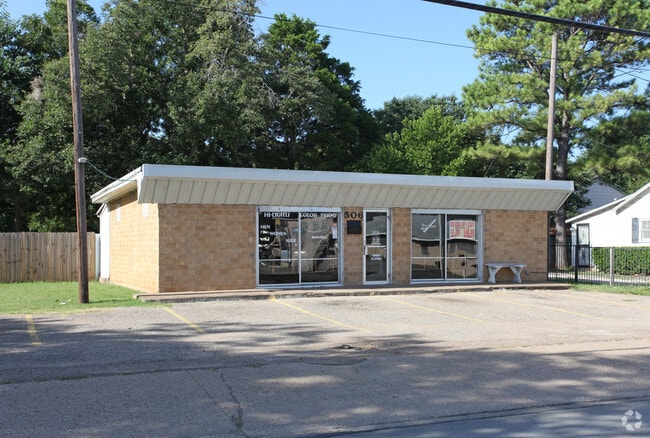
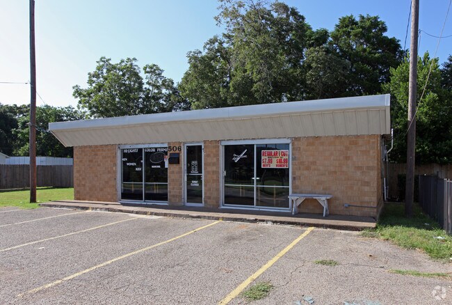
Property Record
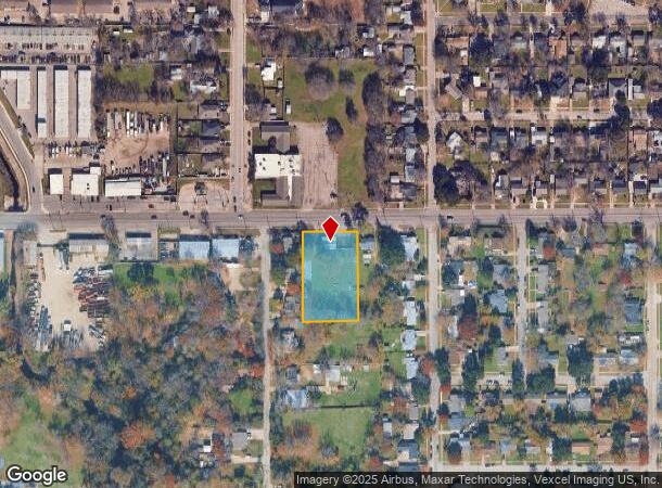
506 W Shady Grove Rd, Irving, TX 75060
NEARBY LISTINGS FOR SALE OR LEASE
Property Detail
506 W Shady Grove Rd
65049406010250000
Henry Gough
Storebuilding
HENRY GOUGH ABST 494 PG 060 160.15X272 84221/0472 CO-DALLAS 6200600102500 16504940601
X
Dallas
48113C0315L
Texas
2024
1 AC
2025
Irving
015101
Dallas/Ft Worth
1,440 SF
Dallas-Fort Worth-Arlington, TX
DEMOGRAPHICS near 506 W Shady Grove Rd
1 Mile
3 Mile
5 Mile
2024 Total Population
15,743
94,301
212,985
2029 Population
15,618
93,100
210,465
Pop Growth 2024-2029
(0.79%)
(1.27%)
(1.18%)
Average Age
36
36
35
2024 Total Households
4,738
29,178
71,972
HH Growth 2024-2029
(1.06%)
(1.51%)
(1.35%)
Median Household Inc
$62,561
$58,663
$60,181
Avg Household Size
3.20
3.10
2.80
2024 Avg HH Vehicles
2.00
2.00
2.00
Median Home Value
$198,672
$206,941
$210,469
Median Year Built
1968
1969
1976
Nearby Places
Map Layers
Map Styles
 Street
 Aerial
- Restaurants
- Banks
- Shops
- Fitness
- Groceries
PUBLIC TRANSPORTATION
COMMUTER RAIL
Downtown Irving/Heritage Crossing Station (TRINITY RAILWAY - Dallas Area Rapid Transit (DART), Trinity Railway Express - Dallas Area Rapid Transit (DART))
DRIVE
WALK
Distance
Downtown Irving/Heritage Crossing Station (TRINITY RAILWAY - Dallas Area Rapid Transit (DART), Trinity Railway Express - Dallas Area Rapid Transit (DART))
4 min
1.3 mi
West Irving (TRINITY RAILWAY - Dallas Area Rapid Transit (DART), Trinity Railway Express - Dallas Area Rapid Transit (DART))
DRIVE
WALK
Distance
West Irving (TRINITY RAILWAY - Dallas Area Rapid Transit (DART), Trinity Railway Express - Dallas Area Rapid Transit (DART))
9 min
4.2 mi
AIRPORT
Dallas Love Field
DRIVE
WALK
Distance
Dallas Love Field
19 min
8.9 mi
Dallas-Fort Worth International
DRIVE
WALK
Distance
Dallas-Fort Worth International
19 min
11.5 mi
Freight Ports
Port of Shreveport
DRIVE
WALK
Distance
Port of Shreveport
227 min
208.1 mi
Nearby Properties
Address
Land Use
TOTAL SIZE
Lot Size
Zoning
Address
Land Use
TOTAL SIZE
Lot Size
Zoning
496,283 SF
246.29 AC
Z236
Address
Land Use
TOTAL SIZE
Lot Size
Zoning
585,000 SF
27.06 AC
Z123
Address
Land Use
TOTAL SIZE
Lot Size
Zoning
168,598 SF
11.33 AC
Z128
Address
Land Use
TOTAL SIZE
Lot Size
Zoning
197,000 SF
25.51 AC
Z236
Address
Land Use
TOTAL SIZE
Lot Size
Zoning
602,000 SF
72.59 AC
Z123
Address
Land Use
TOTAL SIZE
Lot Size
Zoning
643,370 SF
22.95 AC
Z393
Address
Land Use
TOTAL SIZE
Lot Size
Zoning
120,000 SF
9.94 AC
Z393
Address
Land Use
TOTAL SIZE
Lot Size
Zoning
268,930 SF
46.40 AC
Z325
Address
Land Use
TOTAL SIZE
Lot Size
Zoning
294,460 SF
14.78 AC
Z392
Address
Land Use
TOTAL SIZE
Lot Size
Zoning
397,711 SF
18.27 AC
Z123
Address
Land Use
TOTAL SIZE
Lot Size
Zoning
392,220 SF
24.55 AC
Z102
Address
Land Use
TOTAL SIZE
Lot Size
Zoning
237,472 SF
9.31 AC
Z176
Address
Land Use
TOTAL SIZE
Lot Size
Zoning
242,652 SF
12.31 AC
Z392
Address
Land Use
TOTAL SIZE
Lot Size
Zoning
181,389 SF
8.46 AC
Z176
Address
Land Use
TOTAL SIZE
Lot Size
Zoning
322,215 SF
19.77 AC
Z236
Address
Land Use
TOTAL SIZE
Lot Size
Zoning
1,035,018 SF
43.12 AC
Address
Land Use
TOTAL SIZE
Lot Size
Zoning
245,800 SF
12.59 AC
Address
Land Use
TOTAL SIZE
Lot Size
Zoning
81,210 SF
53.19 AC
Z324
Address
Land Use
TOTAL SIZE
Lot Size
Zoning
299,500 SF
15.08 AC
Z236
Address
Land Use
TOTAL SIZE
Lot Size
Zoning
196,670 SF
10.64 AC
Z177
Address
Land Use
TOTAL SIZE
Lot Size
Zoning
206,856 SF
10.20 AC
Z177
Address
Land Use
TOTAL SIZE
Lot Size
Zoning
406,496 SF
42.49 AC
Z128
Address
Land Use
TOTAL SIZE
Lot Size
Zoning
220,762 SF
14.77 AC
Z176
Address
Land Use
TOTAL SIZE
Lot Size
Zoning
143,916 SF
7.22 AC
Z177
Address
Land Use
TOTAL SIZE
Lot Size
Zoning
162,612 SF
7.81 AC
Z392
Address
Land Use
TOTAL SIZE
Lot Size
Zoning
98,200 SF
9.40 AC
Z290
Address
Land Use
TOTAL SIZE
Lot Size
Zoning
97,779 SF
50.53 AC
Z324
Address
Land Use
TOTAL SIZE
Lot Size
Zoning
52,570 SF
1.55 AC
Z58
Address
Land Use
TOTAL SIZE
Lot Size
Zoning
56,470 SF
3.51 AC
Z392
Address
Land Use
TOTAL SIZE
Lot Size
Zoning
139,084 SF
8.85 AC
Z392
The World's #1 Commercial Real Estate Marketplace
Connect with us
© 2025 CoStar Group
The information above has been obtained from sources believed reliable. While we do not doubt its accuracy we have not verified it and make no guarantee, warranty or representation about it. It is your responsibility to independently confirm its accuracy and completeness. Any projections, opinions, assumptions, or estimates used are for example only and do not represent the current or future performance of the property. The value of this transaction to you depends on tax and other factors which should be evaluated by your tax, financial, and legal advisors. You and your advisors should conduct a careful, independent investigation of the property to determine to your satisfaction the suitability of the property for your needs.