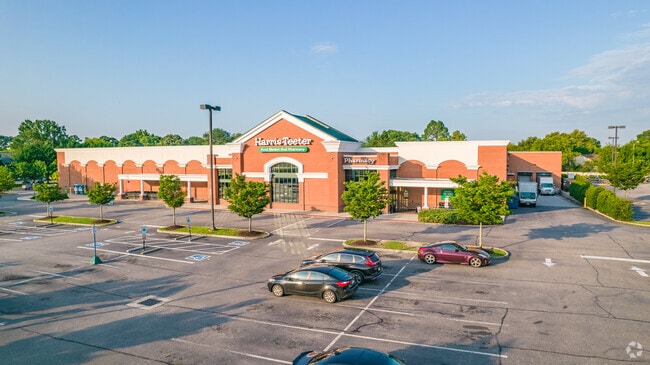
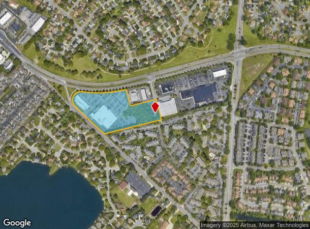
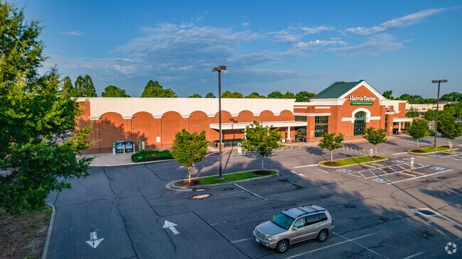
Property Record
5060 Ferrell Pky, Virginia Beach, VA 23464
NEARBY LISTINGS FOR SALE OR LEASE
Property Detail
5060 Ferrell Pky
1465-57-4070
Parcel A-2 Part B-2/
Regionalshoppingcenterormallwithanchorstore
PARCEL A-2 PART B-2/ PARCEL A-2 PART B-2-A
X
Virginia Beach
5155310091G
Virginia
2024
8.62 AC
2025
Kempsville
046213
Hampton Roads
65,707 SF
Virginia Beach-Chesapeake-Norfolk, VA-NC
DEMOGRAPHICS near 5060 Ferrell Pky
1 Mile
3 Mile
5 Mile
2024 Total Population
15,705
118,327
282,018
2029 Population
15,466
117,531
281,552
Pop Growth 2024-2029
(1.52%)
(0.67%)
(0.17%)
Average Age
40
39
39
2024 Total Households
5,985
43,708
108,082
HH Growth 2024-2029
(1.65%)
(0.81%)
(0.20%)
Median Household Inc
$81,088
$88,888
$79,013
Avg Household Size
2.60
2.60
2.50
2024 Avg HH Vehicles
2.00
2.00
2.00
Median Home Value
$273,400
$292,327
$272,591
Median Year Built
1981
1984
1983
Nearby Places
Map Layers
Map Styles
 Street
 Aerial
- Restaurants
- Banks
- Shops
- Fitness
- Groceries
PUBLIC TRANSPORTATION
COMMUTER RAIL
Norfolk (Northeast Regional - Amtrak)
DRIVE
WALK
Distance
Norfolk (Northeast Regional - Amtrak)
14 min
7.9 mi
AIRPORT
Norfolk International
DRIVE
WALK
Distance
Norfolk International
17 min
9.9 mi
Newport News/Williamsburg International
DRIVE
WALK
Distance
Newport News/Williamsburg International
51 min
35.4 mi
Freight Ports
Virginia Port Authority - Portsmouth
DRIVE
WALK
Distance
Virginia Port Authority - Portsmouth
25 min
12.9 mi
Nearby Properties
Address
Land Use
TOTAL SIZE
Lot Size
Zoning
Address
Land Use
TOTAL SIZE
Lot Size
Zoning
4 SF
19.85 AC
A12
Address
Land Use
TOTAL SIZE
Lot Size
Zoning
1 SF
20.80 AC
A18
Address
Land Use
TOTAL SIZE
Lot Size
Zoning
153 SF
88.33 AC
R75
Address
Land Use
TOTAL SIZE
Lot Size
Zoning
17.04 AC
A24
Address
Land Use
TOTAL SIZE
Lot Size
Zoning
9.62 AC
A36
Address
Land Use
TOTAL SIZE
Lot Size
Zoning
18.61 AC
PDH2
Address
Land Use
TOTAL SIZE
Lot Size
Zoning
10.36 AC
A24
Address
Land Use
TOTAL SIZE
Lot Size
Zoning
71,711 SF
11.65 AC
B4
Address
Land Use
TOTAL SIZE
Lot Size
Zoning
3 SF
19.50 AC
A12
Address
Land Use
TOTAL SIZE
Lot Size
Zoning
303,401 SF
12.98 AC
A24
Address
Land Use
TOTAL SIZE
Lot Size
Zoning
1 SF
16.15 AC
PDH1
Address
Land Use
TOTAL SIZE
Lot Size
Zoning
1 SF
12.01 AC
PDH1
Address
Land Use
TOTAL SIZE
Lot Size
Zoning
2 SF
13.12 AC
A24
Address
Land Use
TOTAL SIZE
Lot Size
Zoning
16.03 AC
A24
Address
Land Use
TOTAL SIZE
Lot Size
Zoning
7.46 AC
Address
Land Use
TOTAL SIZE
Lot Size
Zoning
132,309 SF
18.59 AC
O2
Address
Land Use
TOTAL SIZE
Lot Size
Zoning
294,457 SF
47.04 AC
R75
Address
Land Use
TOTAL SIZE
Lot Size
Zoning
330,353 SF
17.61 AC
O2
Address
Land Use
TOTAL SIZE
Lot Size
Zoning
1 SF
10.64 AC
PDH1
Address
Land Use
TOTAL SIZE
Lot Size
Zoning
193,950 SF
10.68 AC
A24
Address
Land Use
TOTAL SIZE
Lot Size
Zoning
17.77 AC
RMF1: MULT
Address
Land Use
TOTAL SIZE
Lot Size
Zoning
163,344 SF
12.07 AC
MULTI: MUL
Address
Land Use
TOTAL SIZE
Lot Size
Zoning
259,135 SF
50.10 AC
R10
Address
Land Use
TOTAL SIZE
Lot Size
Zoning
246,625 SF
35 AC
R10
Address
Land Use
TOTAL SIZE
Lot Size
Zoning
1 SF
9.07 AC
PDH1
Address
Land Use
TOTAL SIZE
Lot Size
Zoning
39,542 SF
4 AC
A36
Address
Land Use
TOTAL SIZE
Lot Size
Zoning
135,237 SF
20.83 AC
B2
Address
Land Use
TOTAL SIZE
Lot Size
Zoning
3 SF
11.80 AC
A18
Address
Land Use
TOTAL SIZE
Lot Size
Zoning
222,640 SF
19.89 AC
B2
Address
Land Use
TOTAL SIZE
Lot Size
Zoning
109,189 SF
15 AC
R75
The World's #1 Commercial Real Estate Marketplace
Connect with us
© 2026 CoStar Group
The information above has been obtained from sources believed reliable. While we do not doubt its accuracy we have not verified it and make no guarantee, warranty or representation about it. It is your responsibility to independently confirm its accuracy and completeness. Any projections, opinions, assumptions, or estimates used are for example only and do not represent the current or future performance of the property. The value of this transaction to you depends on tax and other factors which should be evaluated by your tax, financial, and legal advisors. You and your advisors should conduct a careful, independent investigation of the property to determine to your satisfaction the suitability of the property for your needs.