Property Record
5065 Main St, Trumbull, CT 06611

Save to a Folder
{{folder.Name}}
{{folder.ListingIds.length}} Properties
{{folder.ListingIds.length}} Property
Create a New Folder
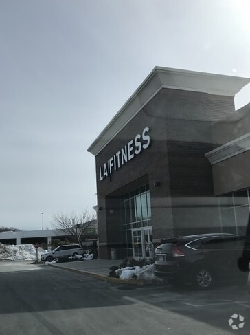
Property Detail
5065 Main St
TRUM-000011E-000000-000014
FAIRFIELD
Commercialnec
Connecticut
BC
14
AE The base floodplain where base flood elevations are provided. AE Zones are now used on new format FIRMs instead of A1-A30 Zones.
77.74 AC
2025
Trumbull
2025
Westchester/So Connecticut
090300
Bridgeport-Stamford-Danbury, CT
NEARBY LISTINGS FOR SALE OR LEASE
DEMOGRAPHICS near 5065 Main St
1 mile
3 mile
5 mile
2025 Total Population
12,318
101,318
256,649
2030 Population
12,938
104,628
263,816
Pop Growth 2025-2030
+ 5.03%
+ 3.27%
+ 2.79%
Average Age
40
40
40
2025 Total Households
4,042
34,537
90,186
HH Growth 2025-2030
+ 5.24%
+ 3.30%
+ 2.89%
Median Household Inc
$111,052
$99,788
$85,233
Avg Household Size
2.70
2.70
2.70
2025 Avg HH Vehicles
2.00
2.00
2.00
Median Home Value
$385,518
$406,735
$419,768
Median Year Built
1958
1958
1956
Nearby Places
Map Layers
Map Styles
 Street
 Aerial
Layers
 Traffic
 Biking
Places
Listings with unknown addresses are not visible on the map
- Restaurants
- Banks
- Shops
- Fitness
- Groceries
PUBLIC TRANSPORTATION
COMMUTER RAIL
Bridgeport Station (New Haven Line - Metro-North Commuter Railroad Company (Metro-North))
Drive
Walk
Distance
Bridgeport Station (New Haven Line - Metro-North Commuter Railroad Company (Metro-North))
10 min
4.6 mi
Drive
Walk
Distance
15 min
6.9 mi
AIRPORT
Tweed/New Haven
Drive
Walk
Distance
Tweed/New Haven
39 min
23.7 mi
Westchester County
Drive
Walk
Distance
Westchester County
52 min
34.5 mi
Long Island MacArthur
Drive
Walk
Distance
Long Island MacArthur
118 min
39.0 mi
Nearby Properties
Address
Land Use
TOTAL SIZE
Lot Size
Zoning
Address
Land Use
TOTAL SIZE
Lot Size
Zoning
10.42 AC
MDD
Address
Land Use
TOTAL SIZE
Lot Size
Zoning
111,525 SF
Address
Land Use
TOTAL SIZE
Lot Size
Zoning
23.95 AC
RB
Address
Land Use
TOTAL SIZE
Lot Size
Zoning
38.62 AC
Address
Land Use
TOTAL SIZE
Lot Size
Zoning
356,837 SF
8.87 AC
RA
Address
Land Use
TOTAL SIZE
Lot Size
Zoning
120,955 SF
9.37 AC
RA
Address
Land Use
TOTAL SIZE
Lot Size
Zoning
22,848 SF
16.84 AC
IL-2
Address
Land Use
TOTAL SIZE
Lot Size
Zoning
335,633 SF
39.70 AC
R3
Address
Land Use
TOTAL SIZE
Lot Size
Zoning
97,554 SF
6.25 AC
DR
Address
Land Use
TOTAL SIZE
Lot Size
Zoning
10.66 AC
ORR
Address
Land Use
TOTAL SIZE
Lot Size
Zoning
1,482 SF
215.26 AC
R3
Address
Land Use
TOTAL SIZE
Lot Size
Zoning
182,000 SF
12.10 AC
IL-2
Address
Land Use
TOTAL SIZE
Lot Size
Zoning
13.15 AC
ORR
Address
Land Use
TOTAL SIZE
Lot Size
Zoning
3.77 AC
RA
Address
Land Use
TOTAL SIZE
Lot Size
Zoning
145,860 SF
2.41 AC
R3
Address
Land Use
TOTAL SIZE
Lot Size
Zoning
14.18 AC
RC
Address
Land Use
TOTAL SIZE
Lot Size
Zoning
109,800 SF
1.24 AC
RA
Address
Land Use
TOTAL SIZE
Lot Size
Zoning
8.41 AC
RC
Address
Land Use
TOTAL SIZE
Lot Size
Zoning
11.87 AC
RA
Address
Land Use
TOTAL SIZE
Lot Size
Zoning
78,692 SF
10.79 AC
MFO
Address
Land Use
TOTAL SIZE
Lot Size
Zoning
82,717 SF
34.40 AC
IL2
Address
Land Use
TOTAL SIZE
Lot Size
Zoning
7.30 AC
R-1
Address
Land Use
TOTAL SIZE
Lot Size
Zoning
13.90 AC
IL2
Address
Land Use
TOTAL SIZE
Lot Size
Zoning
68,810 SF
5.21 AC
R3
Address
Land Use
TOTAL SIZE
Lot Size
Zoning
32.50 AC
AA
Address
Land Use
TOTAL SIZE
Lot Size
Zoning
167,890 SF
12.63 AC
A
Address
Land Use
TOTAL SIZE
Lot Size
Zoning
311.80 AC
AAA
Address
Land Use
TOTAL SIZE
Lot Size
Zoning
12.41 AC
BC
Address
Land Use
TOTAL SIZE
Lot Size
Zoning
62,985 SF
2.42 AC
I-L2
The World's #1 Commercial Real Estate Marketplace
Connect with us
© 2026 CoStar Group
The information above has been obtained from sources believed reliable. While we do not doubt its accuracy we have not verified it and make no guarantee, warranty or representation about it. It is your responsibility to independently confirm its accuracy and completeness. Any projections, opinions, assumptions, or estimates used are for example only and do not represent the current or future performance of the property. The value of this transaction to you depends on tax and other factors which should be evaluated by your tax, financial, and legal advisors. You and your advisors should conduct a careful, independent investigation of the property to determine to your satisfaction the suitability of the property for your needs.