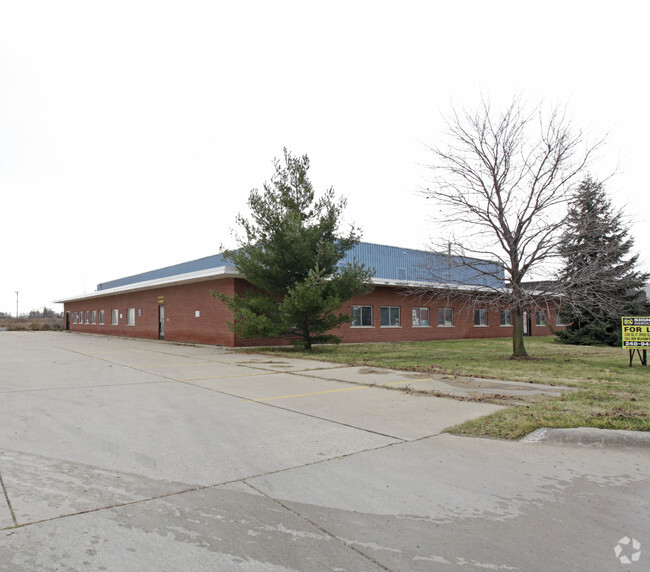
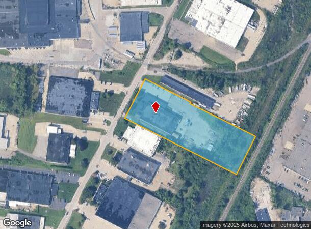
Property Record
50650 E Russell Schmidt Blvd, Chesterfield, MI 48051


NEARBY LISTINGS FOR SALE OR LEASE
Property Detail
50650 E Russell Schmidt Blvd
Detroit-Warren-Dearborn, MI
R C Schmidt & Sons Ind Complex
15-09-19-252-002
R C SCHMIDT & SONS INDUSTRIAL COMPLEX LOT 39
Lightindustrial
Macomb
X
Michigan
26099C0265G
39
2025
3.92 AC
2025
Groesbeck North
221100
Detroit
28,550 SF
DEMOGRAPHICS near 50650 E Russell Schmidt Blvd
1 Mile
3 Mile
5 Mile
2024 Total Population
4,833
48,300
117,769
2029 Population
4,796
48,125
117,091
Pop Growth 2024-2029
(0.77%)
(0.36%)
(0.58%)
Average Age
40
40
40
2024 Total Households
1,904
18,678
44,358
HH Growth 2024-2029
(0.89%)
(0.32%)
(0.52%)
Median Household Inc
$72,838
$87,382
$85,302
Avg Household Size
2.50
2.50
2.60
2024 Avg HH Vehicles
2.00
2.00
2.00
Median Home Value
$240,338
$267,246
$281,754
Median Year Built
1991
1995
1996
Nearby Places
Map Layers
Map Styles
 Street
 Aerial
- Restaurants
- Banks
- Shops
- Fitness
- Groceries
PUBLIC TRANSPORTATION
AIRPORT
Windsor International
DRIVE
WALK
Distance
Windsor International
65 min
41.4 mi
Nearby Properties
Address
Land Use
TOTAL SIZE
Lot Size
Zoning
Address
Land Use
TOTAL SIZE
Lot Size
Zoning
808,240 SF
60.31 AC
RM 3 MU
Address
Land Use
TOTAL SIZE
Lot Size
Zoning
459,100 SF
Address
Land Use
TOTAL SIZE
Lot Size
Zoning
181,094 SF
14.89 AC
C3 GEN
Address
Land Use
TOTAL SIZE
Lot Size
Zoning
143,731 SF
16.25 AC
C2 SHO
Address
Land Use
TOTAL SIZE
Lot Size
Zoning
229,878 SF
19.93 AC
C4 MULT
Address
Land Use
TOTAL SIZE
Lot Size
Zoning
167,281 SF
16.12 AC
C3 GEN
Address
Land Use
TOTAL SIZE
Lot Size
Zoning
600 SF
18.79 AC
R2L
Address
Land Use
TOTAL SIZE
Lot Size
Zoning
124,956 SF
15.78 AC
C2 SHO
Address
Land Use
TOTAL SIZE
Lot Size
Zoning
88,452 SF
8.36 AC
C3 GEN
Address
Land Use
TOTAL SIZE
Lot Size
Zoning
204,318 SF
27.75 AC
C3 GEN
Address
Land Use
TOTAL SIZE
Lot Size
Zoning
679,606 SF
29.98 AC
M2 GEN
Address
Land Use
TOTAL SIZE
Lot Size
Zoning
5,541 SF
130.51 AC
MHP MO
Address
Land Use
TOTAL SIZE
Lot Size
Zoning
218,662 SF
16.61 AC
M2 GEN
Address
Land Use
TOTAL SIZE
Lot Size
Zoning
72,184 SF
69.68 AC
M2 GEN
Address
Land Use
TOTAL SIZE
Lot Size
Zoning
54,865 SF
14 AC
C4
Address
Land Use
TOTAL SIZE
Lot Size
Zoning
118,368 SF
14.46 AC
RM 3 MU
Address
Land Use
TOTAL SIZE
Lot Size
Zoning
184,401 SF
19.98 AC
RM 3 MU
Address
Land Use
TOTAL SIZE
Lot Size
Zoning
134,490 SF
6.09 AC
C4 MULT
Address
Land Use
TOTAL SIZE
Lot Size
Zoning
219,080 SF
20.05 AC
C4 MULT
Address
Land Use
TOTAL SIZE
Lot Size
Zoning
142,306 SF
10.22 AC
M1 LIG
Address
Land Use
TOTAL SIZE
Lot Size
Zoning
16.46 AC
R2L
Address
Land Use
TOTAL SIZE
Lot Size
Zoning
100,982 SF
10.40 AC
C4 MULT
Address
Land Use
TOTAL SIZE
Lot Size
Zoning
156,262 SF
16.23 AC
RM2 MU
Address
Land Use
TOTAL SIZE
Lot Size
Zoning
96,251 SF
11.07 AC
C4 MULT
Address
Land Use
TOTAL SIZE
Lot Size
Zoning
73,860 SF
5.76 AC
I-1
Address
Land Use
TOTAL SIZE
Lot Size
Zoning
78,805 SF
4.94 AC
M2 GEN
Address
Land Use
TOTAL SIZE
Lot Size
Zoning
313,174 SF
22.23 AC
M2 GEN
Address
Land Use
TOTAL SIZE
Lot Size
Zoning
179,200 SF
10.12 AC
RT TECH
Address
Land Use
TOTAL SIZE
Lot Size
Zoning
128,187 SF
8.79 AC
M2 GEN
Address
Land Use
TOTAL SIZE
Lot Size
Zoning
137,092 SF
18.25 AC
C2 SHO
The World's #1 Commercial Real Estate Marketplace
Connect with us
© 2026 CoStar Group
The information above has been obtained from sources believed reliable. While we do not doubt its accuracy we have not verified it and make no guarantee, warranty or representation about it. It is your responsibility to independently confirm its accuracy and completeness. Any projections, opinions, assumptions, or estimates used are for example only and do not represent the current or future performance of the property. The value of this transaction to you depends on tax and other factors which should be evaluated by your tax, financial, and legal advisors. You and your advisors should conduct a careful, independent investigation of the property to determine to your satisfaction the suitability of the property for your needs.