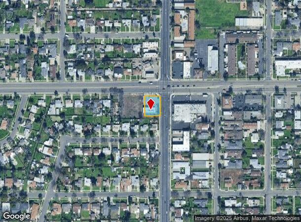
Property Record
509 W Shields Ave, Fresno, CA 93705
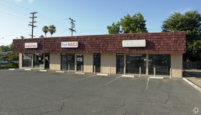
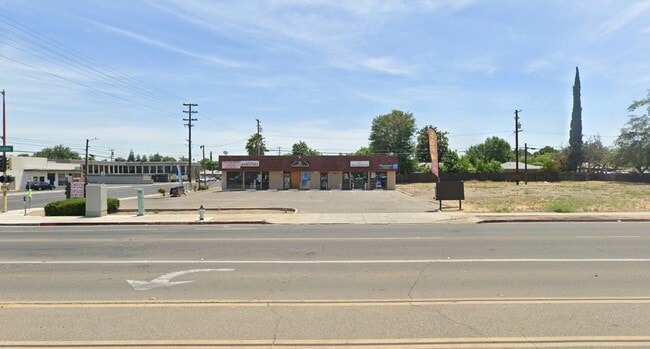
This Property Is For Sale
NEARBY LISTINGS FOR SALE OR LEASE
Property Detail
509 W Shields Ave
Fresno, CA
1074 Kenth Manor
443-032-49
LOT 1 E 40 FT LOT 2 EX STREET TR 1113 KENTH MANOR
Storebuilding
Fresno
X
California
06019C1565H
1
2025
0.29 AC
2025
Midtown West
003702
Fresno
2,541 SF
DEMOGRAPHICS near 509 W Shields Ave
1 Mile
3 Mile
5 Mile
2024 Total Population
25,622
153,148
375,358
2029 Population
26,084
155,978
382,594
Pop Growth 2024-2029
+ 1.80%
+ 1.85%
+ 1.93%
Average Age
35
36
35
2024 Total Households
8,777
51,603
123,280
HH Growth 2024-2029
+ 1.78%
+ 1.86%
+ 1.95%
Median Household Inc
$53,190
$50,024
$52,411
Avg Household Size
2.90
2.80
2.90
2024 Avg HH Vehicles
2.00
2.00
2.00
Median Home Value
$267,144
$265,463
$280,679
Median Year Built
1957
1963
1971
Nearby Places
- Restaurants
- Banks
- Shops
- Fitness
- Groceries
PUBLIC TRANSPORTATION
COMMUTER RAIL
DRIVE
WALK
Distance
9 min
5.0 mi
AIRPORT
Fresno Yosemite International
DRIVE
WALK
Distance
Fresno Yosemite International
12 min
5.9 mi
Nearby Properties
Address
Land Use
TOTAL SIZE
Lot Size
Zoning
Address
Land Use
TOTAL SIZE
Lot Size
Zoning
574,093 SF
25.54 AC
C3
Address
Land Use
TOTAL SIZE
Lot Size
Zoning
39,888 SF
23.72 AC
C3
Address
Land Use
TOTAL SIZE
Lot Size
Zoning
234,370 SF
23 AC
SPLIT
Address
Land Use
TOTAL SIZE
Lot Size
Zoning
232,183 SF
18.32 AC
R2A
Address
Land Use
TOTAL SIZE
Lot Size
Zoning
79,518 SF
2.03 AC
R4
Address
Land Use
TOTAL SIZE
Lot Size
Zoning
110,456 SF
6.56 AC
RMX
Address
Land Use
TOTAL SIZE
Lot Size
Zoning
126,346 SF
5.49 AC
CP
Address
Land Use
TOTAL SIZE
Lot Size
Zoning
126,346 SF
5.31 AC
CP
Address
Land Use
TOTAL SIZE
Lot Size
Zoning
669,447 SF
0.01 AC
C3
Address
Land Use
TOTAL SIZE
Lot Size
Zoning
6,526 SF
50.24 AC
TP
Address
Land Use
TOTAL SIZE
Lot Size
Zoning
70,168 SF
4.97 AC
R3
Address
Land Use
TOTAL SIZE
Lot Size
Zoning
179,240 SF
12 AC
C3
Address
Land Use
TOTAL SIZE
Lot Size
Zoning
203,687 SF
10.63 AC
R3
Address
Land Use
TOTAL SIZE
Lot Size
Zoning
121,250 SF
9.51 AC
R3
Address
Land Use
TOTAL SIZE
Lot Size
Zoning
159,822 SF
9.67 AC
R2
Address
Land Use
TOTAL SIZE
Lot Size
Zoning
81,754 SF
5.75 AC
C3
Address
Land Use
TOTAL SIZE
Lot Size
Zoning
110,341 SF
5.45 AC
R3
Address
Land Use
TOTAL SIZE
Lot Size
Zoning
88,859 SF
2.44 AC
CP
Address
Land Use
TOTAL SIZE
Lot Size
Zoning
191,136 SF
12.12 AC
R2
Address
Land Use
TOTAL SIZE
Lot Size
Zoning
92,096 SF
0.01 AC
C3
Address
Land Use
TOTAL SIZE
Lot Size
Zoning
108,017 SF
2.91 AC
CM
Address
Land Use
TOTAL SIZE
Lot Size
Zoning
82,484 SF
6.41 AC
CP
Address
Land Use
TOTAL SIZE
Lot Size
Zoning
45,944 SF
2.30 AC
CP
Address
Land Use
TOTAL SIZE
Lot Size
Zoning
372,640 SF
4.35 AC
CP
Address
Land Use
TOTAL SIZE
Lot Size
Zoning
57,408 SF
3.12 AC
R3
Address
Land Use
TOTAL SIZE
Lot Size
Zoning
77,520 SF
3.61 AC
C6
Address
Land Use
TOTAL SIZE
Lot Size
Zoning
127,394 SF
8.87 AC
R2
Address
Land Use
TOTAL SIZE
Lot Size
Zoning
81,413 SF
3.01 AC
CP
Address
Land Use
TOTAL SIZE
Lot Size
Zoning
7,742 SF
36.39 AC
TP
Address
Land Use
TOTAL SIZE
Lot Size
Zoning
71,384 SF
6.34 AC
IL
The World's #1 Commercial Real Estate Marketplace
Connect with us
© 2025 CoStar Group
The information above has been obtained from sources believed reliable. While we do not doubt its accuracy we have not verified it and make no guarantee, warranty or representation about it. It is your responsibility to independently confirm its accuracy and completeness. Any projections, opinions, assumptions, or estimates used are for example only and do not represent the current or future performance of the property. The value of this transaction to you depends on tax and other factors which should be evaluated by your tax, financial, and legal advisors. You and your advisors should conduct a careful, independent investigation of the property to determine to your satisfaction the suitability of the property for your needs.