Property Record
507 Marlandwood Rd, Temple, TX 76502
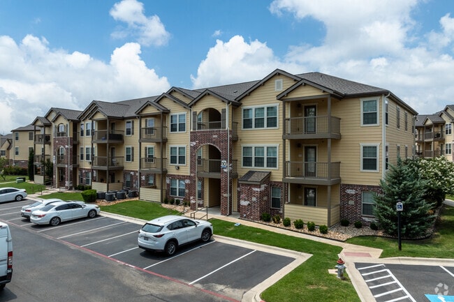

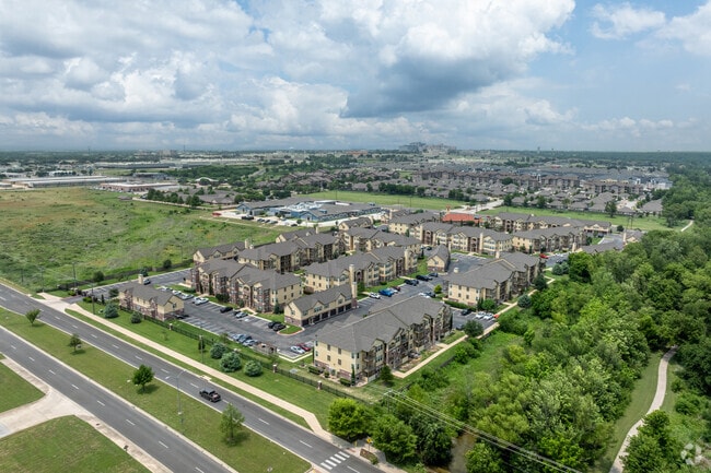
Property Detail
507 Marlandwood Rd
Killeen-Temple, TX
PORTICO AT FRYERS CREEK, BLOCK 001, LOT 0001, 12.000AC
472887
Bell
Multifamilydwelling
Texas
B and X Area of moderate flood hazard, usually the area between the limits of the 100-year and 500-year floods.
1
2025
12 AC
2025
Temple
021304
Killeen/Temple/Fort Hood
250,571 SF
NEARBY LISTINGS FOR SALE OR LEASE
DEMOGRAPHICS near 507 Marlandwood Rd
1 mile
3 mile
5 mile
2025 Total Population
9,227
47,582
75,646
2030 Population
9,845
50,687
80,609
Pop Growth 2025-2030
+ 6.70%
+ 6.53%
+ 6.56%
Average Age
36
39
39
2025 Total Households
3,986
20,022
31,195
HH Growth 2025-2030
+ 7.05%
+ 6.68%
+ 6.67%
Median Household Inc
$66,831
$63,815
$65,052
Avg Household Size
2.20
2.30
2.30
2025 Avg HH Vehicles
1.00
2.00
2.00
Median Home Value
$231,495
$241,529
$242,292
Median Year Built
2001
1986
1986
Nearby Places
Map Layers
Map Styles
 Street
 Aerial
Layers
 Traffic
 Biking
Places
Listings with unknown addresses are not visible on the map
- Restaurants
- Banks
- Shops
- Fitness
- Groceries
PUBLIC TRANSPORTATION
COMMUTER RAIL
Temple (Texas Eagle - Amtrak)
Drive
Walk
Distance
Temple (Texas Eagle - Amtrak)
6 min
3.1 mi
AIRPORT
Killeen Municipal
Drive
Walk
Distance
Killeen Municipal
31 min
22.3 mi
Robert Gray AAF
Drive
Walk
Distance
Robert Gray AAF
51 min
36.2 mi
Freight Ports
Port of Houston
Drive
Walk
Distance
Port of Houston
227 min
179.6 mi
Nearby Properties
Address
Land Use
TOTAL SIZE
Lot Size
Zoning
Address
Land Use
TOTAL SIZE
Lot Size
Zoning
1,656,661 SF
194.39 AC
Address
Land Use
TOTAL SIZE
Lot Size
Zoning
1,546,481 SF
111.97 AC
MF2
Address
Land Use
TOTAL SIZE
Lot Size
Zoning
1 SF
23.50 AC
Address
Land Use
TOTAL SIZE
Lot Size
Zoning
1 SF
30.52 AC
Address
Land Use
TOTAL SIZE
Lot Size
Zoning
202,292 SF
10.17 AC
Address
Land Use
TOTAL SIZE
Lot Size
Zoning
86,326 SF
8.70 AC
MF1
Address
Land Use
TOTAL SIZE
Lot Size
Zoning
77,450 SF
16.51 AC
Address
Land Use
TOTAL SIZE
Lot Size
Zoning
Address
Land Use
TOTAL SIZE
Lot Size
Zoning
180,360 SF
9.66 AC
Address
Land Use
TOTAL SIZE
Lot Size
Zoning
216,109 SF
8.16 AC
Address
Land Use
TOTAL SIZE
Lot Size
Zoning
208,941 SF
9.23 AC
Address
Land Use
TOTAL SIZE
Lot Size
Zoning
1 SF
15 AC
SCHL
Address
Land Use
TOTAL SIZE
Lot Size
Zoning
167,344 SF
11.29 AC
Address
Land Use
TOTAL SIZE
Lot Size
Zoning
287,006 SF
22.67 AC
Address
Land Use
TOTAL SIZE
Lot Size
Zoning
228,154 SF
17.95 AC
Address
Land Use
TOTAL SIZE
Lot Size
Zoning
Address
Land Use
TOTAL SIZE
Lot Size
Zoning
198,957 SF
15.18 AC
Address
Land Use
TOTAL SIZE
Lot Size
Zoning
175,904 SF
20.33 AC
C
Address
Land Use
TOTAL SIZE
Lot Size
Zoning
45,641 SF
3.94 AC
O
Address
Land Use
TOTAL SIZE
Lot Size
Zoning
170,234 SF
8.97 AC
C
Address
Land Use
TOTAL SIZE
Lot Size
Zoning
168,754 SF
10.36 AC
LI
Address
Land Use
TOTAL SIZE
Lot Size
Zoning
153,043 SF
12.61 AC
Address
Land Use
TOTAL SIZE
Lot Size
Zoning
85,860 SF
4.26 AC
Address
Land Use
TOTAL SIZE
Lot Size
Zoning
161,036 SF
52.18 AC
PD
Address
Land Use
TOTAL SIZE
Lot Size
Zoning
71,931 SF
8.64 AC
Address
Land Use
TOTAL SIZE
Lot Size
Zoning
48,463 SF
5.18 AC
Address
Land Use
TOTAL SIZE
Lot Size
Zoning
159,250 SF
0.85 AC
CA
Address
Land Use
TOTAL SIZE
Lot Size
Zoning
81,608 SF
11.15 AC
2F
Address
Land Use
TOTAL SIZE
Lot Size
Zoning
124,897 SF
8.70 AC
C
The World's #1 Commercial Real Estate Marketplace
Connect with us
© 2026 CoStar Group
The information above has been obtained from sources believed reliable. While we do not doubt its accuracy we have not verified it and make no guarantee, warranty or representation about it. It is your responsibility to independently confirm its accuracy and completeness. Any projections, opinions, assumptions, or estimates used are for example only and do not represent the current or future performance of the property. The value of this transaction to you depends on tax and other factors which should be evaluated by your tax, financial, and legal advisors. You and your advisors should conduct a careful, independent investigation of the property to determine to your satisfaction the suitability of the property for your needs.