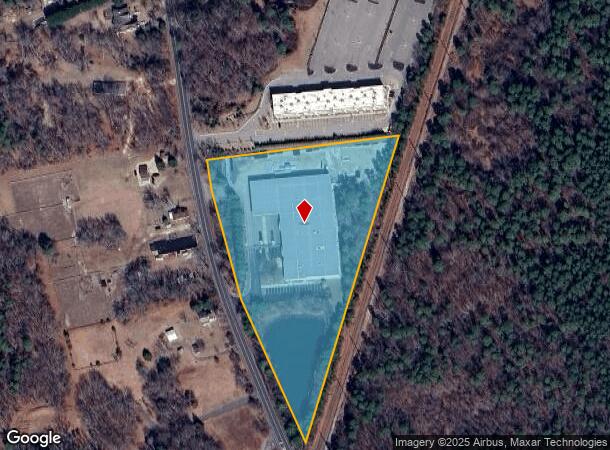
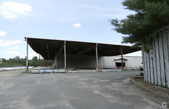
Property Record
507 Oak Glen Rd, Howell, NJ 07731


NEARBY LISTINGS FOR SALE OR LEASE
Property Detail
507 Oak Glen Rd
21-00041-0000-00020-02
Monmouth
Warehouse
New Jersey
X
20.2
34025C0314F
6.42 AC
2024
Western Monmouth
2025
Northern New Jersey
811200
New York-Jersey City-White Plains, NY-NJ
43,886 SF
DEMOGRAPHICS near 507 Oak Glen Rd
1 Mile
3 Mile
5 Mile
2024 Total Population
1,559
55,450
166,482
2029 Population
1,535
55,739
170,647
Pop Growth 2024-2029
(1.54%)
+ 0.52%
+ 2.50%
Average Age
38
31
31
2024 Total Households
495
13,862
43,363
HH Growth 2024-2029
(1.82%)
(0.80%)
+ 1.61%
Median Household Inc
$137,867
$101,363
$80,698
Avg Household Size
3.10
3.60
3.50
2024 Avg HH Vehicles
2.00
2.00
2.00
Median Home Value
$446,641
$417,033
$386,650
Median Year Built
1983
1984
1983
Nearby Places
Map Layers
Map Styles
 Street
 Aerial
- Restaurants
- Banks
- Shops
- Fitness
- Groceries
PUBLIC TRANSPORTATION
AIRPORT
Trenton Mercer
DRIVE
WALK
Distance
Trenton Mercer
60 min
41.7 mi
Freight Ports
New York Container Terminal
DRIVE
WALK
Distance
New York Container Terminal
68 min
50.0 mi
Nearby Properties
Address
Land Use
TOTAL SIZE
Lot Size
Zoning
Address
Land Use
TOTAL SIZE
Lot Size
Zoning
105.04 AC
SED
Address
Land Use
TOTAL SIZE
Lot Size
Zoning
2,382 SF
341 AC
OSP
Address
Land Use
TOTAL SIZE
Lot Size
Zoning
161,340 SF
35.35 AC
HD-1
Address
Land Use
TOTAL SIZE
Lot Size
Zoning
21,876 SF
22.26 AC
B3
Address
Land Use
TOTAL SIZE
Lot Size
Zoning
36.25 AC
R12
Address
Land Use
TOTAL SIZE
Lot Size
Zoning
28.99 AC
HD-1
Address
Land Use
TOTAL SIZE
Lot Size
Zoning
14.73 AC
R-5
Address
Land Use
TOTAL SIZE
Lot Size
Zoning
37,202 SF
14.79 AC
B3
Address
Land Use
TOTAL SIZE
Lot Size
Zoning
162,000 SF
34.35 AC
ARE2
Address
Land Use
TOTAL SIZE
Lot Size
Zoning
8,784 SF
16.16 AC
R-LM
Address
Land Use
TOTAL SIZE
Lot Size
Zoning
17.08 AC
R15
Address
Land Use
TOTAL SIZE
Lot Size
Zoning
360,400 SF
35.98 AC
SED
Address
Land Use
TOTAL SIZE
Lot Size
Zoning
2,736 SF
18.04 AC
R15
Address
Land Use
TOTAL SIZE
Lot Size
Zoning
3.64 AC
R10
Address
Land Use
TOTAL SIZE
Lot Size
Zoning
98,731 SF
13.65 AC
HD
Address
Land Use
TOTAL SIZE
Lot Size
Zoning
141,437 SF
13.35 AC
HD-1
Address
Land Use
TOTAL SIZE
Lot Size
Zoning
125,379 SF
22.16 AC
HD
Address
Land Use
TOTAL SIZE
Lot Size
Zoning
66,990 SF
4.19 AC
RM
Address
Land Use
TOTAL SIZE
Lot Size
Zoning
51,531 SF
13.30 AC
HD
Address
Land Use
TOTAL SIZE
Lot Size
Zoning
2.89 AC
R12
Address
Land Use
TOTAL SIZE
Lot Size
Zoning
1.79 AC
PH1
Address
Land Use
TOTAL SIZE
Lot Size
Zoning
24,630 SF
6.93 AC
HD-1
Address
Land Use
TOTAL SIZE
Lot Size
Zoning
1,124 SF
7.80 AC
B4
Address
Land Use
TOTAL SIZE
Lot Size
Zoning
13,350 SF
71.10 AC
ARE6
Address
Land Use
TOTAL SIZE
Lot Size
Zoning
87,280 SF
11.59 AC
R12
Address
Land Use
TOTAL SIZE
Lot Size
Zoning
123,578 SF
9.28 AC
HD-1
Address
Land Use
TOTAL SIZE
Lot Size
Zoning
9.09 AC
R15
Address
Land Use
TOTAL SIZE
Lot Size
Zoning
8.96 AC
HD
Address
Land Use
TOTAL SIZE
Lot Size
Zoning
6.59 AC
B3
Address
Land Use
TOTAL SIZE
Lot Size
Zoning
1.85 AC
R15
The World's #1 Commercial Real Estate Marketplace
Connect with us
© 2025 CoStar Group
The information above has been obtained from sources believed reliable. While we do not doubt its accuracy we have not verified it and make no guarantee, warranty or representation about it. It is your responsibility to independently confirm its accuracy and completeness. Any projections, opinions, assumptions, or estimates used are for example only and do not represent the current or future performance of the property. The value of this transaction to you depends on tax and other factors which should be evaluated by your tax, financial, and legal advisors. You and your advisors should conduct a careful, independent investigation of the property to determine to your satisfaction the suitability of the property for your needs.