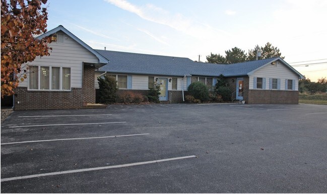
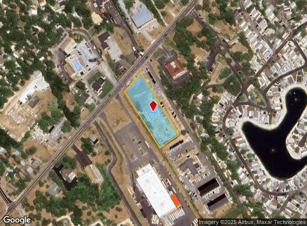
Property Record
507 Route Us 9 S, Marmora, NJ 08223


NEARBY LISTINGS FOR SALE OR LEASE
-
-
View all Marmora listings for lease on LoopNet.com
Property Detail
507 Route Us 9 S
11-00599-0000-00013
ALSO LOT 14 B-1
Officebuilding
Cape May
X
New Jersey
34009C0068F
13
2024
1.23 AC
2025
South Shore/Vineland
020301
Other Market Areas
2,799 SF
Ocean City, NJ
DEMOGRAPHICS near 507 Route Us 9 S
1 Mile
3 Mile
5 Mile
2024 Total Population
1,174
9,492
19,771
2029 Population
965
9,537
19,758
Pop Growth 2024-2029
(17.80%)
+ 0.47%
(0.07%)
Average Age
42
49
48
2024 Total Households
436
4,096
8,665
HH Growth 2024-2029
(19.95%)
+ 0.61%
+ 0.23%
Median Household Inc
$90,046
$97,207
$89,865
Avg Household Size
2.50
2.20
2.20
2024 Avg HH Vehicles
2.00
2.00
2.00
Median Home Value
$296,762
$413,604
$403,052
Median Year Built
1983
1985
1984
Nearby Places
Map Layers
Map Styles
 Street
 Aerial
- Restaurants
- Banks
- Shops
- Fitness
- Groceries
PUBLIC TRANSPORTATION
AIRPORT
Atlantic City International
DRIVE
WALK
Distance
Atlantic City International
46 min
20.4 mi
Freight Ports
Broadway Terminal - Pier 5
DRIVE
WALK
Distance
Broadway Terminal - Pier 5
77 min
62.3 mi
SALE & LEASE HISTORY
LISTING DATE
SALE/LEASE

Sep 10, 2018
For Lease
Nearby Properties
Address
Land Use
TOTAL SIZE
Lot Size
Zoning
Address
Land Use
TOTAL SIZE
Lot Size
Zoning
14.24 AC
MTCD
Address
Land Use
TOTAL SIZE
Lot Size
Zoning
12.80 AC
R
Address
Land Use
TOTAL SIZE
Lot Size
Zoning
Address
Land Use
TOTAL SIZE
Lot Size
Zoning
1.15 AC
Address
Land Use
TOTAL SIZE
Lot Size
Zoning
1.03 AC
Address
Land Use
TOTAL SIZE
Lot Size
Zoning
0.49 AC
Address
Land Use
TOTAL SIZE
Lot Size
Zoning
1,176 SF
31.34 AC
CR
Address
Land Use
TOTAL SIZE
Lot Size
Zoning
29.50 AC
R
Address
Land Use
TOTAL SIZE
Lot Size
Zoning
1.59 AC
Address
Land Use
TOTAL SIZE
Lot Size
Zoning
0.83 AC
Address
Land Use
TOTAL SIZE
Lot Size
Zoning
Address
Land Use
TOTAL SIZE
Lot Size
Zoning
1.55 AC
Address
Land Use
TOTAL SIZE
Lot Size
Zoning
14.47 AC
MTCD
Address
Land Use
TOTAL SIZE
Lot Size
Zoning
5 AC
CCM2
Address
Land Use
TOTAL SIZE
Lot Size
Zoning
100 SF
1.65 AC
MTCD
Address
Land Use
TOTAL SIZE
Lot Size
Zoning
1,820 SF
32.30 AC
C
Address
Land Use
TOTAL SIZE
Lot Size
Zoning
0.39 AC
Address
Land Use
TOTAL SIZE
Lot Size
Zoning
0.57 AC
Address
Land Use
TOTAL SIZE
Lot Size
Zoning
14.59 AC
MTCD
Address
Land Use
TOTAL SIZE
Lot Size
Zoning
0.66 AC
Address
Land Use
TOTAL SIZE
Lot Size
Zoning
11,149 SF
0.16 AC
Address
Land Use
TOTAL SIZE
Lot Size
Zoning
3,584 SF
0.13 AC
Address
Land Use
TOTAL SIZE
Lot Size
Zoning
0.45 AC
Address
Land Use
TOTAL SIZE
Lot Size
Zoning
6.02 AC
MTCD
Address
Land Use
TOTAL SIZE
Lot Size
Zoning
4.94 AC
MTCD
Address
Land Use
TOTAL SIZE
Lot Size
Zoning
840 SF
6.96 AC
MTCD
Address
Land Use
TOTAL SIZE
Lot Size
Zoning
1.32 AC
Address
Land Use
TOTAL SIZE
Lot Size
Zoning
289.19 AC
WTCR
Address
Land Use
TOTAL SIZE
Lot Size
Zoning
0.52 AC
Address
Land Use
TOTAL SIZE
Lot Size
Zoning
1.40 AC
The World's #1 Commercial Real Estate Marketplace
Connect with us
© 2025 CoStar Group
The information above has been obtained from sources believed reliable. While we do not doubt its accuracy we have not verified it and make no guarantee, warranty or representation about it. It is your responsibility to independently confirm its accuracy and completeness. Any projections, opinions, assumptions, or estimates used are for example only and do not represent the current or future performance of the property. The value of this transaction to you depends on tax and other factors which should be evaluated by your tax, financial, and legal advisors. You and your advisors should conduct a careful, independent investigation of the property to determine to your satisfaction the suitability of the property for your needs.