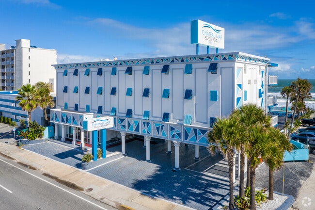
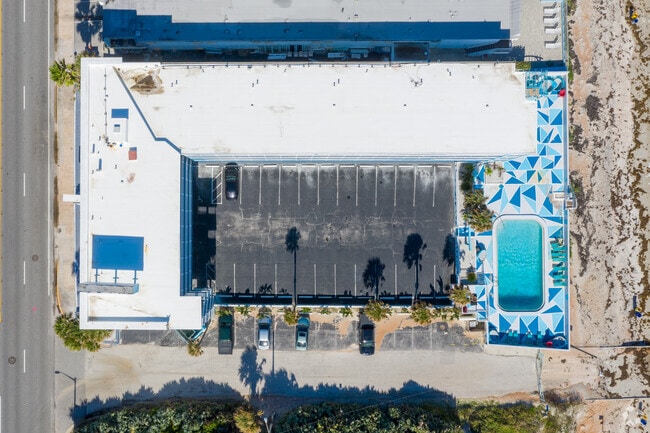
Property Record
507 S Atlantic Ave, Ormond Beach, FL 32176


Property Detail
507 S Atlantic Ave
4223-06-02-0130
LOTS 13 & 14 & N 15 FT OF OLD ST ON S BLK 2 BOSTROMS LOWER ORMOND BEACH MB 1 PG 72 MB 12 PG 37 EXC ST PER OR 4269 PG 2153 PER OR 6007 PG 4021 PER OR 6596 PG 0001 PER OR 6596 PG 0007 PER OR 6667 PG 0505 PER OR 6938 PG 0285 PER OR 6995 PG 1983 PER OR 7
Hotel
Volusia
13B6
Florida
VE and V1-30 Coastal areas with a 1% or greater chance of flooding and an additional hazard associated with storm waves. These areas have a 26% chance of flooding over the life of a 30-year mortgage.
13,14
2025
0.60 AC
2026
Daytona Beach
080500
Deltona/Daytona Beach
31,779 SF
Deltona-Daytona Beach-Ormond Beach, FL
NEARBY LISTINGS FOR SALE OR LEASE
DEMOGRAPHICS near 507 S Atlantic Ave
1 mile
3 mile
5 mile
2025 Total Population
5,469
37,038
98,327
2030 Population
6,078
40,144
106,424
Pop Growth 2025-2030
+ 11.14%
+ 8.39%
+ 8.23%
Average Age
51
48
46
2025 Total Households
2,810
17,464
44,048
HH Growth 2025-2030
+ 11.17%
+ 8.50%
+ 8.39%
Median Household Inc
$67,211
$57,006
$54,370
Avg Household Size
1.90
2.00
2.10
2025 Avg HH Vehicles
2.00
2.00
2.00
Median Home Value
$421,178
$343,308
$312,528
Median Year Built
1973
1974
1975
Nearby Places
Map Layers
Map Styles
 Street
 Aerial
Transit
 Traffic
 Biking
Places
Listings with unknown addresses are not visible on the map
- Restaurants
- Banks
- Shops
- Fitness
- Groceries
PUBLIC TRANSPORTATION
AIRPORT
Daytona Beach International
Drive
Walk
Distance
Daytona Beach International
23 min
10.8 mi
Freight Ports
Port Canaveral
Drive
Walk
Distance
Port Canaveral
100 min
82.3 mi
Nearby Properties
Address
Land Use
TOTAL SIZE
Lot Size
Zoning
Address
Land Use
TOTAL SIZE
Lot Size
Zoning
405,946 SF
2.79 AC
Address
Land Use
TOTAL SIZE
Lot Size
Zoning
300,760 SF
20.75 AC
Address
Land Use
TOTAL SIZE
Lot Size
Zoning
243,418 SF
2.91 AC
02T1
Address
Land Use
TOTAL SIZE
Lot Size
Zoning
403,130 SF
28.45 AC
Address
Land Use
TOTAL SIZE
Lot Size
Zoning
16.50 AC
Address
Land Use
TOTAL SIZE
Lot Size
Zoning
Address
Land Use
TOTAL SIZE
Lot Size
Zoning
Address
Land Use
TOTAL SIZE
Lot Size
Zoning
102,495 SF
10.81 AC
02R2
Address
Land Use
TOTAL SIZE
Lot Size
Zoning
5,426 SF
6.28 AC
09R9
Address
Land Use
TOTAL SIZE
Lot Size
Zoning
144,576 SF
11.19 AC
13R6
Address
Land Use
TOTAL SIZE
Lot Size
Zoning
149,872 SF
20 AC
09R6
Address
Land Use
TOTAL SIZE
Lot Size
Zoning
179,868 SF
0.33 AC
Address
Land Use
TOTAL SIZE
Lot Size
Zoning
102,266 SF
2.20 AC
02T1
Address
Land Use
TOTAL SIZE
Lot Size
Zoning
Address
Land Use
TOTAL SIZE
Lot Size
Zoning
73,540 SF
9.84 AC
02R2
Address
Land Use
TOTAL SIZE
Lot Size
Zoning
101,731 SF
2.58 AC
Address
Land Use
TOTAL SIZE
Lot Size
Zoning
Address
Land Use
TOTAL SIZE
Lot Size
Zoning
135,886 SF
1.18 AC
Address
Land Use
TOTAL SIZE
Lot Size
Zoning
119,331 SF
9.09 AC
Address
Land Use
TOTAL SIZE
Lot Size
Zoning
460,540 SF
20.46 AC
09R6
Address
Land Use
TOTAL SIZE
Lot Size
Zoning
58,429 SF
1.33 AC
02T1
Address
Land Use
TOTAL SIZE
Lot Size
Zoning
58,132 SF
1.50 AC
Address
Land Use
TOTAL SIZE
Lot Size
Zoning
Address
Land Use
TOTAL SIZE
Lot Size
Zoning
94,926 SF
3.85 AC
Address
Land Use
TOTAL SIZE
Lot Size
Zoning
208,503 SF
2.18 AC
02T1
Address
Land Use
TOTAL SIZE
Lot Size
Zoning
77,680 SF
15.04 AC
Address
Land Use
TOTAL SIZE
Lot Size
Zoning
68,131 SF
5.53 AC
Address
Land Use
TOTAL SIZE
Lot Size
Zoning
102,345 SF
2.74 AC
Address
Land Use
TOTAL SIZE
Lot Size
Zoning
57,875 SF
1.95 AC
13B6
Address
Land Use
TOTAL SIZE
Lot Size
Zoning
The World's #1 Commercial Real Estate Marketplace
Connect with us
© 2026 CoStar Group
The information above has been obtained from sources believed reliable. While we do not doubt its accuracy we have not verified it and make no guarantee, warranty or representation about it. It is your responsibility to independently confirm its accuracy and completeness. Any projections, opinions, assumptions, or estimates used are for example only and do not represent the current or future performance of the property. The value of this transaction to you depends on tax and other factors which should be evaluated by your tax, financial, and legal advisors. You and your advisors should conduct a careful, independent investigation of the property to determine to your satisfaction the suitability of the property for your needs.