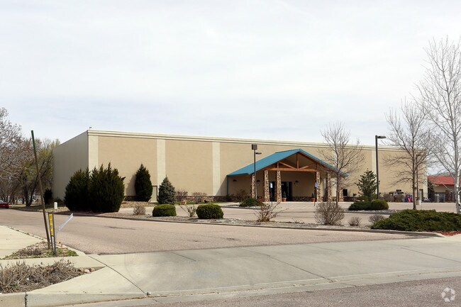
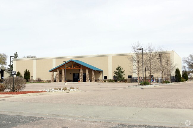
Property Record
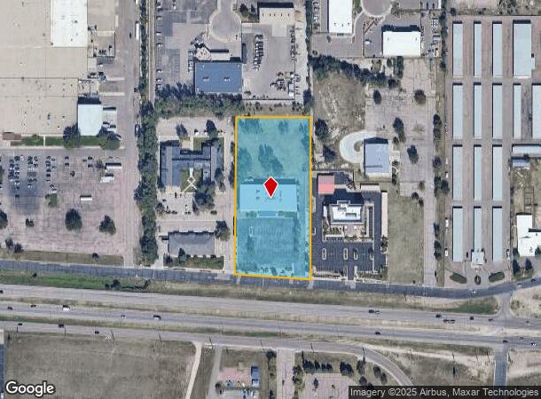
5070 Edison Ave, Colorado Springs, CO 80915
NEARBY LISTINGS FOR SALE OR LEASE
Property Detail
5070 Edison Ave
Colorado Springs, CO
Rustic Hills Sub No 6 Fil No 4
64123-02-009
LOT 4 EX WLY 30.0 FT BLK 1 RUSTIC HILLS SUB NO 6 FIL NO 4 COLO SPGS
Religious
El Paso
X
Colorado
08041C0753G
4
0
3.33 AC
2025
Southeast
006000
Colorado Springs
17,068 SF
DEMOGRAPHICS near 5070 Edison Ave
1 Mile
3 Mile
5 Mile
2024 Total Population
10,425
107,906
244,638
2029 Population
10,978
112,958
255,452
Pop Growth 2024-2029
+ 5.30%
+ 4.68%
+ 4.42%
Average Age
36
36
37
2024 Total Households
4,290
42,560
97,055
HH Growth 2024-2029
+ 5.64%
+ 5.00%
+ 4.70%
Median Household Inc
$53,307
$57,190
$63,322
Avg Household Size
2.40
2.40
2.40
2024 Avg HH Vehicles
2.00
2.00
2.00
Median Home Value
$258,213
$294,634
$328,156
Median Year Built
1978
1978
1979
Nearby Places
Map Layers
Map Styles
 Street
 Aerial
- Restaurants
- Banks
- Shops
- Fitness
- Groceries
PUBLIC TRANSPORTATION
AIRPORT
City of Colorado Springs Municipal
DRIVE
WALK
Distance
City of Colorado Springs Municipal
12 min
4.7 mi
Nearby Properties
Address
Land Use
TOTAL SIZE
Lot Size
Zoning
Address
Land Use
TOTAL SIZE
Lot Size
Zoning
8,806 SF
124.24 AC
PZ
Address
Land Use
TOTAL SIZE
Lot Size
Zoning
229,081 SF
9.87 AC
MX-N CU SS
Address
Land Use
TOTAL SIZE
Lot Size
Zoning
200,642 SF
6.65 AC
MX-M HR AO
Address
Land Use
TOTAL SIZE
Lot Size
Zoning
167,120 SF
10.59 AC
MX-L/CR CU
Address
Land Use
TOTAL SIZE
Lot Size
Zoning
233,194 SF
30 AC
R-1 6 AO S
Address
Land Use
TOTAL SIZE
Lot Size
Zoning
162,945 SF
20.05 AC
BP/CR CU A
Address
Land Use
TOTAL SIZE
Lot Size
Zoning
117,648 SF
3,971.89 AC
APD
Address
Land Use
TOTAL SIZE
Lot Size
Zoning
75,831 SF
3.37 AC
R-5 P
Address
Land Use
TOTAL SIZE
Lot Size
Zoning
131,545 SF
12.46 AC
R-5/CR CU
Address
Land Use
TOTAL SIZE
Lot Size
Zoning
138,773 SF
4.45 AC
R-5
Address
Land Use
TOTAL SIZE
Lot Size
Zoning
87,577 SF
14.24 AC
CS CAD-O
Address
Land Use
TOTAL SIZE
Lot Size
Zoning
704,240 SF
41.99 AC
BP/CR UV A
Address
Land Use
TOTAL SIZE
Lot Size
Zoning
8,096 SF
123.01 AC
PF APZ2 AO
Address
Land Use
TOTAL SIZE
Lot Size
Zoning
65,400 SF
13.65 AC
PF CU
Address
Land Use
TOTAL SIZE
Lot Size
Zoning
86,290 SF
8.01 AC
I-2 CAD-O
Address
Land Use
TOTAL SIZE
Lot Size
Zoning
98,638 SF
7.22 AC
MX-M AO
Address
Land Use
TOTAL SIZE
Lot Size
Zoning
152,517 SF
12.17 AC
MX-L
Address
Land Use
TOTAL SIZE
Lot Size
Zoning
23,535 SF
15.91 AC
BP/CR AO
Address
Land Use
TOTAL SIZE
Lot Size
Zoning
69,078 SF
0.03 AC
Address
Land Use
TOTAL SIZE
Lot Size
Zoning
76,203 SF
8.15 AC
PF
Address
Land Use
TOTAL SIZE
Lot Size
Zoning
55,432 SF
4.78 AC
R-5
Address
Land Use
TOTAL SIZE
Lot Size
Zoning
60,324 SF
1.72 AC
R-5
Address
Land Use
TOTAL SIZE
Lot Size
Zoning
92,568 SF
11.08 AC
MX-M/CR
Address
Land Use
TOTAL SIZE
Lot Size
Zoning
45,328 SF
3.87 AC
R-4 CAD-O
Address
Land Use
TOTAL SIZE
Lot Size
Zoning
185,508 SF
16.48 AC
BP/CR AO S
Address
Land Use
TOTAL SIZE
Lot Size
Zoning
72,105 SF
11.32 AC
MX-T AO
Address
Land Use
TOTAL SIZE
Lot Size
Zoning
45,579 SF
4.50 AC
MX-M AO
Address
Land Use
TOTAL SIZE
Lot Size
Zoning
38,818 SF
0.90 AC
PDZ CU
Address
Land Use
TOTAL SIZE
Lot Size
Zoning
24,437 SF
4.78 AC
BP/CR AO
Address
Land Use
TOTAL SIZE
Lot Size
Zoning
32,760 SF
0.90 AC
PDZ CU
The World's #1 Commercial Real Estate Marketplace
Connect with us
© 2026 CoStar Group
The information above has been obtained from sources believed reliable. While we do not doubt its accuracy we have not verified it and make no guarantee, warranty or representation about it. It is your responsibility to independently confirm its accuracy and completeness. Any projections, opinions, assumptions, or estimates used are for example only and do not represent the current or future performance of the property. The value of this transaction to you depends on tax and other factors which should be evaluated by your tax, financial, and legal advisors. You and your advisors should conduct a careful, independent investigation of the property to determine to your satisfaction the suitability of the property for your needs.