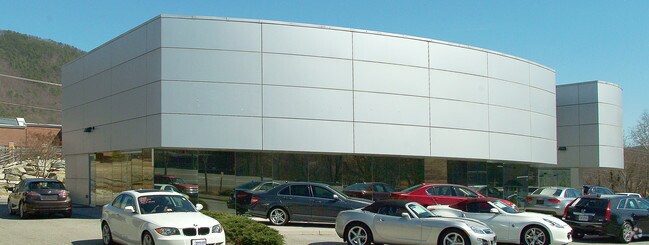
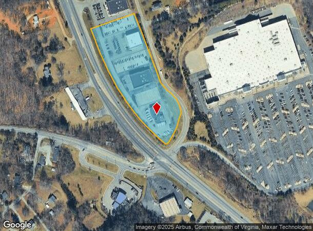
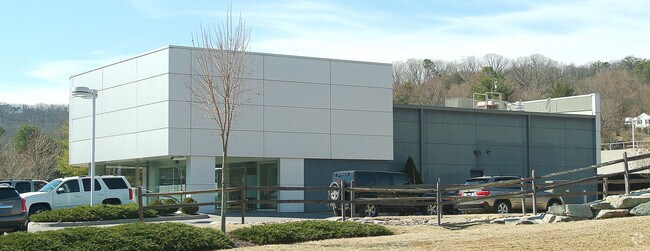
Property Record
5070 Franklin Rd Sw, Roanoke, VA 24014
NEARBY LISTINGS FOR SALE OR LEASE
Property Detail
5070 Franklin Rd Sw
Roanoke, VA
Rt 220 South Commercial
088.03-01-35
LT 5A BOUNDARY SUR FOR CROSSROADS HOLDINGS LLC OFF FRANKLIN RD
Vehiclerentalsvehiclesales
Roanoke
X
Virginia
51067C0055C
5a
2025
4.63 AC
2025
Southwest Roanoke
030900
Roanoke
4,353 SF
DEMOGRAPHICS near 5070 Franklin Rd Sw
1 Mile
3 Mile
5 Mile
2024 Total Population
1,203
24,013
78,281
2029 Population
1,185
23,856
77,304
Pop Growth 2024-2029
(1.50%)
(0.65%)
(1.25%)
Average Age
45
44
42
2024 Total Households
576
10,895
35,360
HH Growth 2024-2029
(1.74%)
(0.67%)
(1.31%)
Median Household Inc
$52,500
$72,469
$61,615
Avg Household Size
2.10
2.20
2.10
2024 Avg HH Vehicles
2.00
2.00
2.00
Median Home Value
$366,860
$296,600
$245,001
Median Year Built
1983
1977
1966
Nearby Places
Map Layers
Map Styles
 Street
 Aerial
- Restaurants
- Banks
- Shops
- Fitness
- Groceries
PUBLIC TRANSPORTATION
COMMUTER RAIL
Roanoke (Northeast Regional - Amtrak)
DRIVE
WALK
Distance
Roanoke (Northeast Regional - Amtrak)
11 min
6.1 mi
AIRPORT
Roanoke/Blacksburg Regional (Woodrum Field)
DRIVE
WALK
Distance
Roanoke/Blacksburg Regional (Woodrum Field)
20 min
11.6 mi
Freight Ports
Virginia Port Authority - Richmond
DRIVE
WALK
Distance
Virginia Port Authority - Richmond
227 min
167.6 mi
Nearby Properties
Address
Land Use
TOTAL SIZE
Lot Size
Zoning
Address
Land Use
TOTAL SIZE
Lot Size
Zoning
149,370 SF
40 AC
R1
Address
Land Use
TOTAL SIZE
Lot Size
Zoning
10,030 SF
32.18 AC
RMF
Address
Land Use
TOTAL SIZE
Lot Size
Zoning
32,814 SF
18.14 AC
C1
Address
Land Use
TOTAL SIZE
Lot Size
Zoning
6.29 AC
MXPUD
Address
Land Use
TOTAL SIZE
Lot Size
Zoning
10,143 SF
25.30 AC
R3
Address
Land Use
TOTAL SIZE
Lot Size
Zoning
2.75 AC
Address
Land Use
TOTAL SIZE
Lot Size
Zoning
6,298 SF
43.38 AC
C2
Address
Land Use
TOTAL SIZE
Lot Size
Zoning
146,345 SF
5.97 AC
MX
Address
Land Use
TOTAL SIZE
Lot Size
Zoning
56,496 SF
19.14 AC
I2C
Address
Land Use
TOTAL SIZE
Lot Size
Zoning
187,130 SF
29.96 AC
C2
Address
Land Use
TOTAL SIZE
Lot Size
Zoning
11,529 SF
9.78 AC
R4
Address
Land Use
TOTAL SIZE
Lot Size
Zoning
583 SF
7.16 AC
INPUD
Address
Land Use
TOTAL SIZE
Lot Size
Zoning
11,529 SF
9.75 AC
R4
Address
Land Use
TOTAL SIZE
Lot Size
Zoning
7.75 AC
Address
Land Use
TOTAL SIZE
Lot Size
Zoning
71,400 SF
10.24 AC
R1
Address
Land Use
TOTAL SIZE
Lot Size
Zoning
10,143 SF
10.33 AC
R4
Address
Land Use
TOTAL SIZE
Lot Size
Zoning
61,198 SF
7.30 AC
I-1
Address
Land Use
TOTAL SIZE
Lot Size
Zoning
57,615 SF
4.06 AC
MX
Address
Land Use
TOTAL SIZE
Lot Size
Zoning
136,895 SF
19.45 AC
C2C
Address
Land Use
TOTAL SIZE
Lot Size
Zoning
38,958 SF
7.99 AC
MX
Address
Land Use
TOTAL SIZE
Lot Size
Zoning
47,949 SF
26.63 AC
C2S
Address
Land Use
TOTAL SIZE
Lot Size
Zoning
79,605 SF
2.50 AC
C2C
Address
Land Use
TOTAL SIZE
Lot Size
Zoning
12,618 SF
13.74 AC
R3
Address
Land Use
TOTAL SIZE
Lot Size
Zoning
9,792 SF
6.72 AC
RMF
Address
Land Use
TOTAL SIZE
Lot Size
Zoning
27,384 SF
10.23 AC
R4
Address
Land Use
TOTAL SIZE
Lot Size
Zoning
87,332 SF
4.60 AC
CLS
Address
Land Use
TOTAL SIZE
Lot Size
Zoning
12,345 SF
4.85 AC
RMF
Address
Land Use
TOTAL SIZE
Lot Size
Zoning
71,819 SF
21.12 AC
ARS
Address
Land Use
TOTAL SIZE
Lot Size
Zoning
98,823 SF
3.76 AC
C2
Address
Land Use
TOTAL SIZE
Lot Size
Zoning
106,511 SF
10.58 AC
CG
The World's #1 Commercial Real Estate Marketplace
Connect with us
© 2026 CoStar Group
The information above has been obtained from sources believed reliable. While we do not doubt its accuracy we have not verified it and make no guarantee, warranty or representation about it. It is your responsibility to independently confirm its accuracy and completeness. Any projections, opinions, assumptions, or estimates used are for example only and do not represent the current or future performance of the property. The value of this transaction to you depends on tax and other factors which should be evaluated by your tax, financial, and legal advisors. You and your advisors should conduct a careful, independent investigation of the property to determine to your satisfaction the suitability of the property for your needs.