Property Record
5070 Mh Rourk Dr, Shallotte, NC 28470


NEARBY LISTINGS FOR SALE OR LEASE
-
-
View all Shallotte listings for sale on LoopNet.com
Property Detail
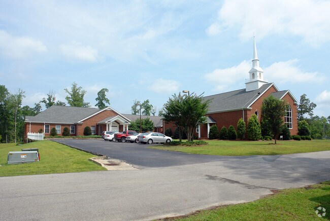
5070 Mh Rourk Dr
1970005512
5 AC PLAT R/138&T/339
Religious
Brunswick
AE
North Carolina
3720108700K
5 AC
0
West Brunswick
2025
Wilmington
020514
Myrtle Beach-Conway-North Myrtle Beach, SC-NC
9,136 SF
DEMOGRAPHICS near 5070 Mh Rourk Dr
1 Mile
3 Mile
5 Mile
2024 Total Population
1,045
7,942
18,169
2029 Population
1,333
10,169
23,638
Pop Growth 2024-2029
+ 27.56%
+ 28.04%
+ 30.10%
Average Age
47
45
47
2024 Total Households
439
3,266
7,904
HH Growth 2024-2029
+ 27.33%
+ 27.89%
+ 30.17%
Median Household Inc
$59,905
$57,840
$55,053
Avg Household Size
2.30
2.30
2.20
2024 Avg HH Vehicles
2.00
2.00
2.00
Median Home Value
$253,628
$224,146
$239,597
Median Year Built
1996
1996
1995
Nearby Places
Map Layers
Map Styles
 Street
 Aerial
- Restaurants
- Banks
- Shops
- Fitness
- Groceries
PUBLIC TRANSPORTATION
AIRPORT
Wilmington International
DRIVE
WALK
Distance
Wilmington International
66 min
41.1 mi
Myrtle Beach International
DRIVE
WALK
Distance
Myrtle Beach International
62 min
42.9 mi
Freight Ports
Port of Wilmington
DRIVE
WALK
Distance
Port of Wilmington
56 min
36.8 mi
Nearby Properties
Address
Land Use
TOTAL SIZE
Lot Size
Zoning
Address
Land Use
TOTAL SIZE
Lot Size
Zoning
188,832 SF
54.14 AC
HB
Address
Land Use
TOTAL SIZE
Lot Size
Zoning
36,883 SF
56.92 AC
MF10
Address
Land Use
TOTAL SIZE
Lot Size
Zoning
117,289 SF
60.11 AC
HB
Address
Land Use
TOTAL SIZE
Lot Size
Zoning
152,873 SF
22.53 AC
HB
Address
Land Use
TOTAL SIZE
Lot Size
Zoning
63,093 SF
19.15 AC
HB
Address
Land Use
TOTAL SIZE
Lot Size
Zoning
2,090 SF
11.18 AC
HB
Address
Land Use
TOTAL SIZE
Lot Size
Zoning
14,118 SF
5.20 AC
MF14
Address
Land Use
TOTAL SIZE
Lot Size
Zoning
6,596 SF
9 AC
MF14
Address
Land Use
TOTAL SIZE
Lot Size
Zoning
156,048 SF
19.88 AC
HB
Address
Land Use
TOTAL SIZE
Lot Size
Zoning
50,061 SF
8.03 AC
CLD
Address
Land Use
TOTAL SIZE
Lot Size
Zoning
33,004 SF
18.71 AC
HB
Address
Land Use
TOTAL SIZE
Lot Size
Zoning
135,622 SF
16.65 AC
HB
Address
Land Use
TOTAL SIZE
Lot Size
Zoning
8,240 SF
5.59 AC
R10
Address
Land Use
TOTAL SIZE
Lot Size
Zoning
33,954 SF
4.40 AC
HB
Address
Land Use
TOTAL SIZE
Lot Size
Zoning
8,010 SF
4.55 AC
R10
Address
Land Use
TOTAL SIZE
Lot Size
Zoning
40,599 SF
25.39 AC
HB
Address
Land Use
TOTAL SIZE
Lot Size
Zoning
108,500 SF
11.59 AC
HB
Address
Land Use
TOTAL SIZE
Lot Size
Zoning
39,316 SF
10.75 AC
R15
Address
Land Use
TOTAL SIZE
Lot Size
Zoning
48,536 SF
7.70 AC
HB
Address
Land Use
TOTAL SIZE
Lot Size
Zoning
39,452 SF
6.03 AC
HB
Address
Land Use
TOTAL SIZE
Lot Size
Zoning
8,112 SF
2.15 AC
HB
Address
Land Use
TOTAL SIZE
Lot Size
Zoning
37,266 SF
40.14 AC
MF10
Address
Land Use
TOTAL SIZE
Lot Size
Zoning
27,598 SF
1.91 AC
HB
Address
Land Use
TOTAL SIZE
Lot Size
Zoning
24,646 SF
10.25 AC
HB
Address
Land Use
TOTAL SIZE
Lot Size
Zoning
4,800 SF
9.72 AC
CI
Address
Land Use
TOTAL SIZE
Lot Size
Zoning
42,817 SF
4.61 AC
MF10
Address
Land Use
TOTAL SIZE
Lot Size
Zoning
31,476 SF
3.26 AC
HB
Address
Land Use
TOTAL SIZE
Lot Size
Zoning
12,338 SF
3.19 AC
CB
Address
Land Use
TOTAL SIZE
Lot Size
Zoning
11,908 SF
5.67 AC
R15
Address
Land Use
TOTAL SIZE
Lot Size
Zoning
628.28 AC
HI
The World's #1 Commercial Real Estate Marketplace
Connect with us
© 2025 CoStar Group
The information above has been obtained from sources believed reliable. While we do not doubt its accuracy we have not verified it and make no guarantee, warranty or representation about it. It is your responsibility to independently confirm its accuracy and completeness. Any projections, opinions, assumptions, or estimates used are for example only and do not represent the current or future performance of the property. The value of this transaction to you depends on tax and other factors which should be evaluated by your tax, financial, and legal advisors. You and your advisors should conduct a careful, independent investigation of the property to determine to your satisfaction the suitability of the property for your needs.