Property Record
5071 Highway 73, Evergreen, CO 80439
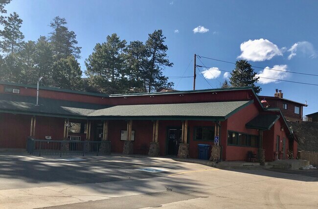


Property Detail
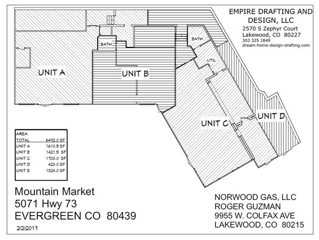
5071 Highway 73
51-103-14-006
SECTION 10 TOWNSHIP 05 RANGE 71 QTR SW SUBDIVISIONCD 589200 SUBDIVISIONNAME PEARSON ADDITION BLOCK LOT 0096 SIZE: 25483 TRACT 00A VALUE: .585 SECTION 10 TOWNSHIP 05 RANGE 71 QTR SW SUBDIVISIONCD 589200 SUBDIVISIONNAME PEARSON ADDITION BLOCK LOT 0098
Commercialnec
Jefferson
PD
Colorado
C and X Area of minimal flood hazard, usually depicted on FIRMs as above the 500-year flood level.
96,98
0
0.79 AC
2025
Southwest Outlying
012030
Denver
5,260 SF
Denver-Aurora-Centennial, CO
NEARBY LISTINGS FOR SALE OR LEASE
DEMOGRAPHICS near 5071 Highway 73
1 mile
3 mile
5 mile
2025 Total Population
2,423
12,385
23,029
2030 Population
2,428
12,306
22,856
Pop Growth 2025-2030
+ 0.21%
(0.64%)
(0.75%)
Average Age
46
46
46
2025 Total Households
1,028
5,055
9,293
HH Growth 2025-2030
+ 0.19%
(0.69%)
(0.85%)
Median Household Inc
$100,833
$144,899
$150,847
Avg Household Size
2.30
2.40
2.40
2025 Avg HH Vehicles
2.00
2.00
2.00
Median Home Value
$780,201
$846,976
$894,005
Median Year Built
1972
1977
1978
Nearby Places
Map Layers
Map Styles
 Street
 Aerial
Layers
 Traffic
 Biking
Places
Listings with unknown addresses are not visible on the map
- Restaurants
- Banks
- Shops
- Fitness
- Groceries
SALE & LEASE HISTORY
LISTING DATE
SALE/LEASE

May 16, 2018
For Sale
Jan 04, 2017
For Sale
Jan 04, 2017
For Sale
Dec 20, 2016
For Lease
Apr 02, 2020
For Lease
Nearby Properties
Address
Land Use
TOTAL SIZE
Lot Size
Zoning
Address
Land Use
TOTAL SIZE
Lot Size
Zoning
400 SF
427.06 AC
CO
Address
Land Use
TOTAL SIZE
Lot Size
Zoning
59,012 SF
2.40 AC
PD
Address
Land Use
TOTAL SIZE
Lot Size
Zoning
35,890 SF
1.84 AC
PD
Address
Land Use
TOTAL SIZE
Lot Size
Zoning
769.90 AC
CO
Address
Land Use
TOTAL SIZE
Lot Size
Zoning
681.88 AC
CO
Address
Land Use
TOTAL SIZE
Lot Size
Zoning
134,644 SF
51.80 AC
A2
Address
Land Use
TOTAL SIZE
Lot Size
Zoning
480 AC
CO
Address
Land Use
TOTAL SIZE
Lot Size
Zoning
116.70 AC
CO
Address
Land Use
TOTAL SIZE
Lot Size
Zoning
54,443 SF
4.16 AC
PD
Address
Land Use
TOTAL SIZE
Lot Size
Zoning
17,262 SF
0.91 AC
PD
Address
Land Use
TOTAL SIZE
Lot Size
Zoning
17,554 SF
25.57 AC
A2
Address
Land Use
TOTAL SIZE
Lot Size
Zoning
320 AC
CO
Address
Land Use
TOTAL SIZE
Lot Size
Zoning
53,371 SF
3.69 AC
C1
Address
Land Use
TOTAL SIZE
Lot Size
Zoning
51,104 SF
5.57 AC
PD
Address
Land Use
TOTAL SIZE
Lot Size
Zoning
34,581 SF
1.98 AC
PD
Address
Land Use
TOTAL SIZE
Lot Size
Zoning
37,332 SF
5.06 AC
PD
Address
Land Use
TOTAL SIZE
Lot Size
Zoning
70.88 AC
A2
Address
Land Use
TOTAL SIZE
Lot Size
Zoning
25,104 SF
1.47 AC
PD
Address
Land Use
TOTAL SIZE
Lot Size
Zoning
5,298 SF
147.29 AC
CO
Address
Land Use
TOTAL SIZE
Lot Size
Zoning
256.19 AC
CO
Address
Land Use
TOTAL SIZE
Lot Size
Zoning
44,090 SF
12.35 AC
A2
Address
Land Use
TOTAL SIZE
Lot Size
Zoning
17,510 SF
5.24 AC
MR1
Address
Land Use
TOTAL SIZE
Lot Size
Zoning
18,139 SF
10.36 AC
A2
Address
Land Use
TOTAL SIZE
Lot Size
Zoning
14,563 SF
2.21 AC
Address
Land Use
TOTAL SIZE
Lot Size
Zoning
17,230 SF
1.85 AC
C1
Address
Land Use
TOTAL SIZE
Lot Size
Zoning
27,699 SF
2.59 AC
PD
Address
Land Use
TOTAL SIZE
Lot Size
Zoning
11,317 SF
1.45 AC
C1
Address
Land Use
TOTAL SIZE
Lot Size
Zoning
5,753 SF
1.37 AC
PD
Address
Land Use
TOTAL SIZE
Lot Size
Zoning
32,461 SF
3.92 AC
C1
Address
Land Use
TOTAL SIZE
Lot Size
Zoning
23,920 SF
2.04 AC
PD
The World's #1 Commercial Real Estate Marketplace
Connect with us
© 2026 CoStar Group
The information above has been obtained from sources believed reliable. While we do not doubt its accuracy we have not verified it and make no guarantee, warranty or representation about it. It is your responsibility to independently confirm its accuracy and completeness. Any projections, opinions, assumptions, or estimates used are for example only and do not represent the current or future performance of the property. The value of this transaction to you depends on tax and other factors which should be evaluated by your tax, financial, and legal advisors. You and your advisors should conduct a careful, independent investigation of the property to determine to your satisfaction the suitability of the property for your needs.