Property Record
5074 N Pine St, Davenport, IA 52806
NEARBY LISTINGS FOR SALE OR LEASE
Property Detail
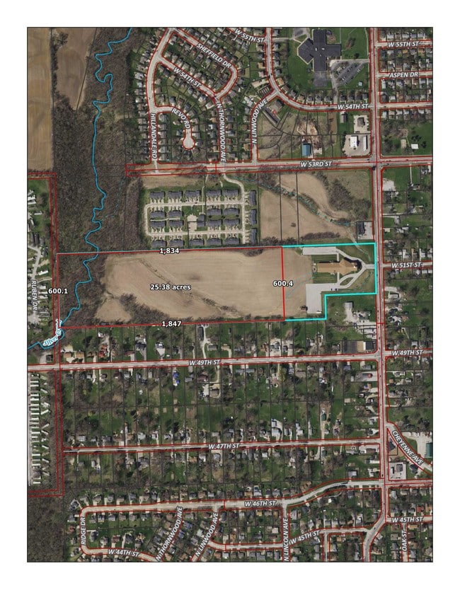
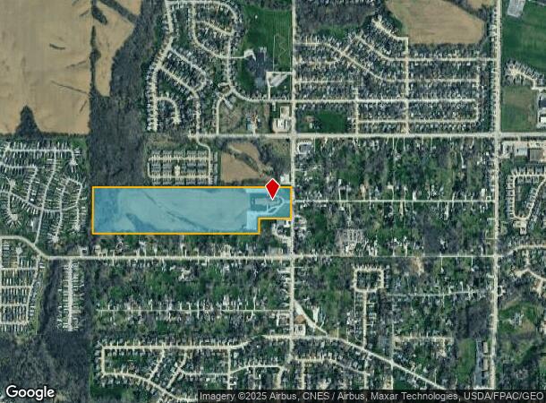
5074 N Pine St
U0939-01B
Section 09
Religious
SEC:09 TWP:78 RNG:03S/2 N/2 SE/4 9-78-3(EXC SUBD) ALSO (EXCPRT SOLD TO COZADDOC #07813-89)
AE
Scott
19163C0355H
Iowa
0
33.76 AC
2025
Greater Davenport
012602
Davenport/Moline/Rock Island
17,590 SF
Davenport-Moline-Rock Island, IA-IL
DEMOGRAPHICS near 5074 N Pine St
1 Mile
3 Mile
5 Mile
2024 Total Population
9,816
50,465
100,653
2029 Population
9,742
50,067
100,189
Pop Growth 2024-2029
(0.75%)
(0.79%)
(0.46%)
Average Age
39
40
39
2024 Total Households
3,884
20,789
42,445
HH Growth 2024-2029
(0.82%)
(0.88%)
(0.47%)
Median Household Inc
$58,920
$57,422
$54,609
Avg Household Size
2.50
2.30
2.20
2024 Avg HH Vehicles
2.00
2.00
2.00
Median Home Value
$168,302
$152,111
$153,323
Median Year Built
1977
1969
1965
Nearby Places
Map Layers
Map Styles
 Street
 Aerial
- Restaurants
- Banks
- Shops
- Fitness
- Groceries
PUBLIC TRANSPORTATION
AIRPORT
Quad Cities International
DRIVE
WALK
Distance
Quad Cities International
28 min
14.3 mi
Freight Ports
Port Milwaukee
DRIVE
WALK
Distance
Port Milwaukee
243 min
214.5 mi
SALE & LEASE HISTORY
LISTING DATE
SALE/LEASE

Jun 04, 2019
For Sale
Nearby Properties
Address
Land Use
TOTAL SIZE
Lot Size
Zoning
Address
Land Use
TOTAL SIZE
Lot Size
Zoning
2,615,134 SF
120.68 AC
Address
Land Use
TOTAL SIZE
Lot Size
Zoning
3,516 SF
26.74 AC
Address
Land Use
TOTAL SIZE
Lot Size
Zoning
2,545,300 SF
159.73 AC
Address
Land Use
TOTAL SIZE
Lot Size
Zoning
300,100 SF
14.87 AC
Address
Land Use
TOTAL SIZE
Lot Size
Zoning
27,225 SF
40.34 AC
Address
Land Use
TOTAL SIZE
Lot Size
Zoning
27,306 SF
50.57 AC
Address
Land Use
TOTAL SIZE
Lot Size
Zoning
688 SF
56.76 AC
Address
Land Use
TOTAL SIZE
Lot Size
Zoning
247,966 SF
14.14 AC
Address
Land Use
TOTAL SIZE
Lot Size
Zoning
300,718 SF
14.71 AC
Address
Land Use
TOTAL SIZE
Lot Size
Zoning
63,359 SF
12.01 AC
Address
Land Use
TOTAL SIZE
Lot Size
Zoning
352,332 SF
34.16 AC
Address
Land Use
TOTAL SIZE
Lot Size
Zoning
472,569 SF
47.24 AC
Address
Land Use
TOTAL SIZE
Lot Size
Zoning
12,500 SF
578.76 AC
Address
Land Use
TOTAL SIZE
Lot Size
Zoning
25,176 SF
13.85 AC
Address
Land Use
TOTAL SIZE
Lot Size
Zoning
77,187 SF
0.88 AC
Address
Land Use
TOTAL SIZE
Lot Size
Zoning
70,098 SF
9.72 AC
Address
Land Use
TOTAL SIZE
Lot Size
Zoning
8,000 SF
4.59 AC
Address
Land Use
TOTAL SIZE
Lot Size
Zoning
197,946 SF
18.64 AC
Address
Land Use
TOTAL SIZE
Lot Size
Zoning
4,800 SF
18.86 AC
Address
Land Use
TOTAL SIZE
Lot Size
Zoning
86,976 SF
40 AC
Address
Land Use
TOTAL SIZE
Lot Size
Zoning
99,540 SF
10.95 AC
Address
Land Use
TOTAL SIZE
Lot Size
Zoning
111,452 SF
40 AC
Address
Land Use
TOTAL SIZE
Lot Size
Zoning
12,648 SF
8.28 AC
Address
Land Use
TOTAL SIZE
Lot Size
Zoning
50,880 SF
11.36 AC
Address
Land Use
TOTAL SIZE
Lot Size
Zoning
54,644 SF
2.41 AC
Address
Land Use
TOTAL SIZE
Lot Size
Zoning
213,686 SF
23.29 AC
Address
Land Use
TOTAL SIZE
Lot Size
Zoning
3,000 SF
59.92 AC
Address
Land Use
TOTAL SIZE
Lot Size
Zoning
348,893 SF
15.30 AC
Address
Land Use
TOTAL SIZE
Lot Size
Zoning
78,037 SF
17.06 AC
Address
Land Use
TOTAL SIZE
Lot Size
Zoning
54,026 SF
The World's #1 Commercial Real Estate Marketplace
Connect with us
© 2026 CoStar Group
The information above has been obtained from sources believed reliable. While we do not doubt its accuracy we have not verified it and make no guarantee, warranty or representation about it. It is your responsibility to independently confirm its accuracy and completeness. Any projections, opinions, assumptions, or estimates used are for example only and do not represent the current or future performance of the property. The value of this transaction to you depends on tax and other factors which should be evaluated by your tax, financial, and legal advisors. You and your advisors should conduct a careful, independent investigation of the property to determine to your satisfaction the suitability of the property for your needs.