Property Record
5075 Cascade Rd Se, Grand Rapids, MI 49546

Save to a Folder
{{folder.Name}}
{{folder.ListingIds.length}} Properties
{{folder.ListingIds.length}} Property
Create a New Folder
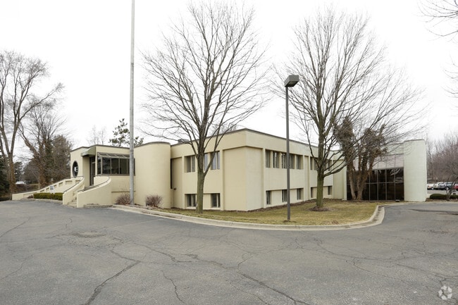
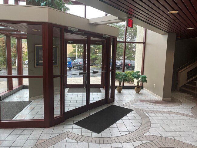
Property Detail
5075 Cascade Rd Se
41-15-31-326-021
PART SW 1/4 COM 1265 FT S & 825 FT W FROM NE COR THEREOF TH S 222 FT TH SWLY 238 FT TO CL OF CASCADE RD TH SELY ALONG SD CL
Commercialnec
Kent
PO
Michigan
B and X Area of moderate flood hazard, usually the area between the limits of the 100-year and 500-year floods.
2.49 AC
2025
Ada/Lowell
2025
West Michigan
011902
Grand Rapids-Wyoming-Kentwood, MI
18,774 SF
NEARBY LISTINGS FOR SALE OR LEASE
DEMOGRAPHICS near 5075 Cascade Rd Se
1 mile
3 mile
5 mile
2025 Total Population
6,604
42,765
115,897
2030 Population
6,861
43,858
118,550
Pop Growth 2025-2030
+ 3.89%
+ 2.56%
+ 2.29%
Average Age
41
40
40
2025 Total Households
2,326
15,752
44,319
HH Growth 2025-2030
+ 4.08%
+ 2.57%
+ 2.31%
Median Household Inc
$137,806
$104,476
$100,230
Avg Household Size
2.80
2.50
2.50
2025 Avg HH Vehicles
2.00
2.00
2.00
Median Home Value
$456,981
$435,027
$392,147
Median Year Built
1996
1985
1976
Nearby Places
Map Layers
Map Styles
 Street
 Aerial
Layers
 Traffic
 Biking
Places
Listings with unknown addresses are not visible on the map
- Restaurants
- Banks
- Shops
- Fitness
- Groceries
PUBLIC TRANSPORTATION
COMMUTER RAIL
Drive
Walk
Distance
13 min
9.4 mi
AIRPORT
Gerald R Ford International
Drive
Walk
Distance
Gerald R Ford International
17 min
7.3 mi
SALE & LEASE HISTORY
LISTING DATE
SALE/LEASE

Sep 26, 2019
For Lease
Nov 08, 2019
For Lease
Nov 08, 2019
For Lease
Aug 21, 2023
For Lease
Nearby Properties
Address
Land Use
TOTAL SIZE
Lot Size
Zoning
Address
Land Use
TOTAL SIZE
Lot Size
Zoning
277.36 AC
I
Address
Land Use
TOTAL SIZE
Lot Size
Zoning
476,572 SF
51.60 AC
R4
Address
Land Use
TOTAL SIZE
Lot Size
Zoning
521,735 SF
52.16 AC
MON-C
Address
Land Use
TOTAL SIZE
Lot Size
Zoning
709,488 SF
106.95 AC
LI
Address
Land Use
TOTAL SIZE
Lot Size
Zoning
126,805 SF
9.36 AC
C4
Address
Land Use
TOTAL SIZE
Lot Size
Zoning
151,708 SF
7.22 AC
C4
Address
Land Use
TOTAL SIZE
Lot Size
Zoning
Address
Land Use
TOTAL SIZE
Lot Size
Zoning
341,808 SF
27.73 AC
HC-PUD
Address
Land Use
TOTAL SIZE
Lot Size
Zoning
23.99 AC
PUD
Address
Land Use
TOTAL SIZE
Lot Size
Zoning
22.46 AC
MON-MDR
Address
Land Use
TOTAL SIZE
Lot Size
Zoning
226,877 SF
22.40 AC
R2
Address
Land Use
TOTAL SIZE
Lot Size
Zoning
19.40 AC
MON-MDR
Address
Land Use
TOTAL SIZE
Lot Size
Zoning
127,141 SF
17.04 AC
C2
Address
Land Use
TOTAL SIZE
Lot Size
Zoning
285,875 SF
37.86 AC
TI
Address
Land Use
TOTAL SIZE
Lot Size
Zoning
138,278 SF
35.63 AC
R-1
Address
Land Use
TOTAL SIZE
Lot Size
Zoning
15.94 AC
MON-MDR
Address
Land Use
TOTAL SIZE
Lot Size
Zoning
97,263 SF
19.37 AC
MON-MDR
Address
Land Use
TOTAL SIZE
Lot Size
Zoning
16.91 AC
MON-MDR
Address
Land Use
TOTAL SIZE
Lot Size
Zoning
154,643 SF
10.96 AC
O-PUD
Address
Land Use
TOTAL SIZE
Lot Size
Zoning
183,583 SF
9.12 AC
R-1
Address
Land Use
TOTAL SIZE
Lot Size
Zoning
51,148 SF
26.38 AC
R-PUD-1
Address
Land Use
TOTAL SIZE
Lot Size
Zoning
17,671 SF
15.18 AC
MON-MDR
Address
Land Use
TOTAL SIZE
Lot Size
Zoning
184,186 SF
19.24 AC
R4
Address
Land Use
TOTAL SIZE
Lot Size
Zoning
209,417 SF
19.51 AC
C4
Address
Land Use
TOTAL SIZE
Lot Size
Zoning
140,700 SF
15.45 AC
R4
Address
Land Use
TOTAL SIZE
Lot Size
Zoning
18.86 AC
MON-MDR
Address
Land Use
TOTAL SIZE
Lot Size
Zoning
105,029 SF
5.65 AC
C
Address
Land Use
TOTAL SIZE
Lot Size
Zoning
23.01 AC
MON-MDR
Address
Land Use
TOTAL SIZE
Lot Size
Zoning
236,061 SF
11.09 AC
PUD
Address
Land Use
TOTAL SIZE
Lot Size
Zoning
9.94 AC
MON-MDR
The World's #1 Commercial Real Estate Marketplace
Connect with us
© 2026 CoStar Group
The information above has been obtained from sources believed reliable. While we do not doubt its accuracy we have not verified it and make no guarantee, warranty or representation about it. It is your responsibility to independently confirm its accuracy and completeness. Any projections, opinions, assumptions, or estimates used are for example only and do not represent the current or future performance of the property. The value of this transaction to you depends on tax and other factors which should be evaluated by your tax, financial, and legal advisors. You and your advisors should conduct a careful, independent investigation of the property to determine to your satisfaction the suitability of the property for your needs.