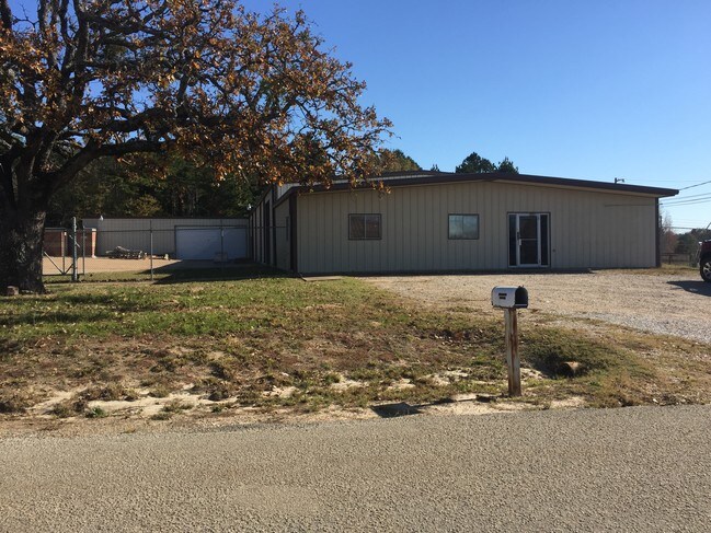
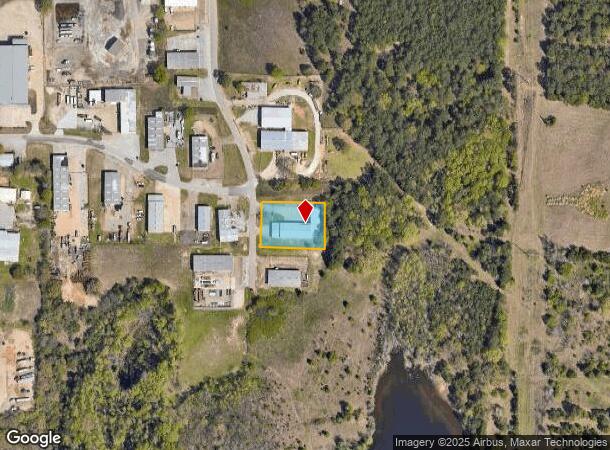
Property Record
5076 Shirley Dr, Tyler, TX 75708
NEARBY LISTINGS FOR SALE OR LEASE
Property Detail
5076 Shirley Dr
Tyler, TX
Negem Ind Park
1-80872-0003-00-001000
NEGEM IND PARKBLOCK 3 LOT 1
Warehouse
Smith
X
Texas
48423C0245D
1
2024
0.69 AC
2025
Tyler & Longview
001701
Other Market Areas
9,250 SF
DEMOGRAPHICS near 5076 Shirley Dr
1 Mile
3 Mile
5 Mile
2024 Total Population
2,131
23,997
70,204
2029 Population
2,333
26,230
76,611
Pop Growth 2024-2029
+ 9.48%
+ 9.31%
+ 9.13%
Average Age
32
34
36
2024 Total Households
670
7,630
24,516
HH Growth 2024-2029
+ 8.96%
+ 8.89%
+ 8.69%
Median Household Inc
$49,149
$47,251
$49,744
Avg Household Size
3.10
2.90
2.60
2024 Avg HH Vehicles
2.00
2.00
2.00
Median Home Value
$120,555
$112,718
$130,669
Median Year Built
1977
1971
1966
Nearby Places
Map Layers
Map Styles
 Street
 Aerial
- Restaurants
- Banks
- Shops
- Fitness
- Groceries
PUBLIC TRANSPORTATION
AIRPORT
Tyler Pounds Regional
DRIVE
WALK
Distance
Tyler Pounds Regional
22 min
12.0 mi
Freight Ports
Port of Shreveport
DRIVE
WALK
Distance
Port of Shreveport
117 min
103.4 mi
SALE & LEASE HISTORY
LISTING DATE
SALE/LEASE

Nov 09, 2020
For Lease
Jan 28, 2018
For Sale
Aug 09, 2021
For Lease
Apr 03, 2018
For Lease
Nearby Properties
Address
Land Use
TOTAL SIZE
Lot Size
Zoning
Address
Land Use
TOTAL SIZE
Lot Size
Zoning
14,000 SF
367.52 AC
M2
Address
Land Use
TOTAL SIZE
Lot Size
Zoning
Address
Land Use
TOTAL SIZE
Lot Size
Zoning
Address
Land Use
TOTAL SIZE
Lot Size
Zoning
38,010 SF
12.07 AC
R1A
Address
Land Use
TOTAL SIZE
Lot Size
Zoning
Address
Land Use
TOTAL SIZE
Lot Size
Zoning
229,190 SF
26 AC
Address
Land Use
TOTAL SIZE
Lot Size
Zoning
Address
Land Use
TOTAL SIZE
Lot Size
Zoning
25.54 AC
INT
Address
Land Use
TOTAL SIZE
Lot Size
Zoning
186,870 SF
18.22 AC
Address
Land Use
TOTAL SIZE
Lot Size
Zoning
2,521 SF
13.36 AC
RMF
Address
Land Use
TOTAL SIZE
Lot Size
Zoning
520,081 SF
24.62 AC
M2
Address
Land Use
TOTAL SIZE
Lot Size
Zoning
3,222 SF
7.43 AC
RMF
Address
Land Use
TOTAL SIZE
Lot Size
Zoning
Address
Land Use
TOTAL SIZE
Lot Size
Zoning
16,800 SF
12.99 AC
RMF
Address
Land Use
TOTAL SIZE
Lot Size
Zoning
128.51 AC
M2
Address
Land Use
TOTAL SIZE
Lot Size
Zoning
41,052 SF
5.32 AC
Address
Land Use
TOTAL SIZE
Lot Size
Zoning
1,375 SF
8.50 AC
RMF
Address
Land Use
TOTAL SIZE
Lot Size
Zoning
4.20 AC
PMF
Address
Land Use
TOTAL SIZE
Lot Size
Zoning
3,312 SF
10.58 AC
Address
Land Use
TOTAL SIZE
Lot Size
Zoning
72,000 SF
24.16 AC
Address
Land Use
TOTAL SIZE
Lot Size
Zoning
22,030 SF
12.93 AC
M2
Address
Land Use
TOTAL SIZE
Lot Size
Zoning
3,319 SF
18 AC
Address
Land Use
TOTAL SIZE
Lot Size
Zoning
Address
Land Use
TOTAL SIZE
Lot Size
Zoning
Address
Land Use
TOTAL SIZE
Lot Size
Zoning
24,752 SF
0.22 AC
DBAC
Address
Land Use
TOTAL SIZE
Lot Size
Zoning
19,152 SF
22.07 AC
Address
Land Use
TOTAL SIZE
Lot Size
Zoning
14,574 SF
1.72 AC
INT
Address
Land Use
TOTAL SIZE
Lot Size
Zoning
27,006 SF
12.54 AC
Address
Land Use
TOTAL SIZE
Lot Size
Zoning
25.81 AC
R1B
Address
Land Use
TOTAL SIZE
Lot Size
Zoning
59,269 SF
8.73 AC
The World's #1 Commercial Real Estate Marketplace
Connect with us
© 2026 CoStar Group
The information above has been obtained from sources believed reliable. While we do not doubt its accuracy we have not verified it and make no guarantee, warranty or representation about it. It is your responsibility to independently confirm its accuracy and completeness. Any projections, opinions, assumptions, or estimates used are for example only and do not represent the current or future performance of the property. The value of this transaction to you depends on tax and other factors which should be evaluated by your tax, financial, and legal advisors. You and your advisors should conduct a careful, independent investigation of the property to determine to your satisfaction the suitability of the property for your needs.