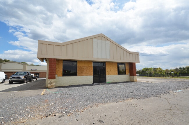
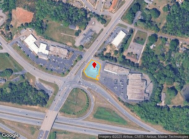
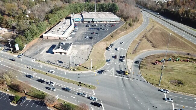
Property Record
5076 Styers Ferry Rd, Lewisville, NC 27023
NEARBY LISTINGS FOR SALE OR LEASE
Property Detail
5076 Styers Ferry Rd
Winston-Salem, NC
Lewisville/Clemmons @ I-40
5885-90-9375
VACANT LO:103A BL:4431 BU:1
Storebuilding
Forsyth
X
North Carolina
3710589500J
103a
2024
0.53 AC
2025
Western Forsyth County
004011
Greensboro/Winston-Salem
2,400 SF
DEMOGRAPHICS near 5076 Styers Ferry Rd
1 Mile
3 Mile
5 Mile
2024 Total Population
4,456
38,712
90,383
2029 Population
4,620
40,266
93,940
Pop Growth 2024-2029
+ 3.68%
+ 4.01%
+ 3.94%
Average Age
42
41
42
2024 Total Households
1,786
16,217
38,053
HH Growth 2024-2029
+ 3.64%
+ 3.97%
+ 3.93%
Median Household Inc
$77,164
$81,770
$79,957
Avg Household Size
2.40
2.40
2.30
2024 Avg HH Vehicles
2.00
2.00
2.00
Median Home Value
$249,725
$289,177
$285,244
Median Year Built
1990
1990
1987
Nearby Places
Map Layers
Map Styles
 Street
 Aerial
- Restaurants
- Banks
- Shops
- Fitness
- Groceries
PUBLIC TRANSPORTATION
AIRPORT
Piedmont Triad International
DRIVE
WALK
Distance
Piedmont Triad International
43 min
31.9 mi
SALE & LEASE HISTORY
LISTING DATE
SALE/LEASE

Oct 19, 2021
For Sale
Nov 18, 2022
For Lease
Nov 18, 2022
For Sale
Jul 25, 2018
For Sale
Apr 19, 2022
For Sale
Nearby Properties
Address
Land Use
TOTAL SIZE
Lot Size
Zoning
Address
Land Use
TOTAL SIZE
Lot Size
Zoning
124,972 SF
19.32 AC
MU-S
Address
Land Use
TOTAL SIZE
Lot Size
Zoning
95,995 SF
31.49 AC
RM12,RM18
Address
Land Use
TOTAL SIZE
Lot Size
Zoning
61,125 SF
8.66 AC
MU-S
Address
Land Use
TOTAL SIZE
Lot Size
Zoning
121,563 SF
22.42 AC
PB-S
Address
Land Use
TOTAL SIZE
Lot Size
Zoning
275,051 SF
32.47 AC
PB-S,RM18
Address
Land Use
TOTAL SIZE
Lot Size
Zoning
257,080 SF
23.47 AC
HB-S
Address
Land Use
TOTAL SIZE
Lot Size
Zoning
189,737 SF
20.53 AC
CD1-S
Address
Land Use
TOTAL SIZE
Lot Size
Zoning
60,258 SF
8.04 AC
PB-S
Address
Land Use
TOTAL SIZE
Lot Size
Zoning
200,651 SF
60 AC
IP
Address
Land Use
TOTAL SIZE
Lot Size
Zoning
99,812 SF
18.33 AC
RM12
Address
Land Use
TOTAL SIZE
Lot Size
Zoning
179,142 SF
42.52 AC
RS9
Address
Land Use
TOTAL SIZE
Lot Size
Zoning
402,885 SF
19.63 AC
HB-S
Address
Land Use
TOTAL SIZE
Lot Size
Zoning
64,236 SF
14.71 AC
RM12-S
Address
Land Use
TOTAL SIZE
Lot Size
Zoning
80,171 SF
4.32 AC
PB-S
Address
Land Use
TOTAL SIZE
Lot Size
Zoning
56,638 SF
16.54 AC
RM8-S
Address
Land Use
TOTAL SIZE
Lot Size
Zoning
68,277 SF
9.82 AC
GB-S
Address
Land Use
TOTAL SIZE
Lot Size
Zoning
89,801 SF
9.50 AC
PB-S
Address
Land Use
TOTAL SIZE
Lot Size
Zoning
75,507 SF
12.46 AC
RM18
Address
Land Use
TOTAL SIZE
Lot Size
Zoning
75,361 SF
15.20 AC
RM12
Address
Land Use
TOTAL SIZE
Lot Size
Zoning
45,427 SF
17.84 AC
RM8-S
Address
Land Use
TOTAL SIZE
Lot Size
Zoning
100,044 SF
7.93 AC
HB,HB-S
Address
Land Use
TOTAL SIZE
Lot Size
Zoning
52,554 SF
25.46 AC
RS9
Address
Land Use
TOTAL SIZE
Lot Size
Zoning
98,396 SF
18.91 AC
RM8-S
Address
Land Use
TOTAL SIZE
Lot Size
Zoning
69,062 SF
13.44 AC
RM18
Address
Land Use
TOTAL SIZE
Lot Size
Zoning
32,696 SF
1.64 AC
PB-S
Address
Land Use
TOTAL SIZE
Lot Size
Zoning
69,992 SF
16.14 AC
RM8
Address
Land Use
TOTAL SIZE
Lot Size
Zoning
100 SF
4.12 AC
IP-S
Address
Land Use
TOTAL SIZE
Lot Size
Zoning
79,355 SF
14.91 AC
IP-S
Address
Land Use
TOTAL SIZE
Lot Size
Zoning
60,709 SF
34.21 AC
C-S
Address
Land Use
TOTAL SIZE
Lot Size
Zoning
82,587 SF
7.23 AC
HB,HB-S
The World's #1 Commercial Real Estate Marketplace
Connect with us
© 2025 CoStar Group
The information above has been obtained from sources believed reliable. While we do not doubt its accuracy we have not verified it and make no guarantee, warranty or representation about it. It is your responsibility to independently confirm its accuracy and completeness. Any projections, opinions, assumptions, or estimates used are for example only and do not represent the current or future performance of the property. The value of this transaction to you depends on tax and other factors which should be evaluated by your tax, financial, and legal advisors. You and your advisors should conduct a careful, independent investigation of the property to determine to your satisfaction the suitability of the property for your needs.