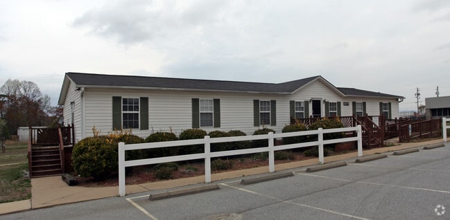
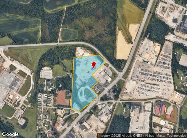
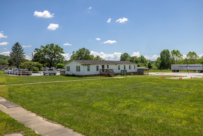
Property Record
177 Rockwell Dr, Fletcher, NC 28732
Current Lease Availabilities
NEARBY LISTINGS FOR SALE OR LEASE
Property Detail
177 Rockwell Dr
Asheville, NC
RECOMBINATION 12.221 ACRES LO2 PL2023-15273
9652443118
Henderson
Officebuilding
North Carolina
2025
3118
2025
12.40 AC
930501
Henderson County
1,320 SF
Asheville
DEMOGRAPHICS near 177 Rockwell Dr
1 Mile
3 Mile
5 Mile
2024 Total Population
2,871
18,661
51,318
2029 Population
2,968
19,310
53,268
Pop Growth 2024-2029
+ 3.38%
+ 3.48%
+ 3.80%
Average Age
41
42
43
2024 Total Households
1,135
7,592
21,116
HH Growth 2024-2029
+ 3.61%
+ 3.49%
+ 3.66%
Median Household Inc
$75,368
$70,241
$69,518
Avg Household Size
2.50
2.40
2.40
2024 Avg HH Vehicles
2.00
2.00
2.00
Median Home Value
$299,782
$308,055
$316,366
Median Year Built
1994
1995
1991
Nearby Places
Map Layers
Map Styles
 Street
 Aerial
- Restaurants
- Banks
- Shops
- Fitness
- Groceries
PUBLIC TRANSPORTATION
AIRPORT
Asheville Regional
DRIVE
WALK
Distance
Asheville Regional
8 min
5.0 mi
Freight Ports
North Charleston Terminal
DRIVE
WALK
Distance
North Charleston Terminal
271 min
242.3 mi
Nearby Properties
Address
Land Use
TOTAL SIZE
Lot Size
Zoning
Address
Land Use
TOTAL SIZE
Lot Size
Zoning
107,063 SF
567.34 AC
AI
Address
Land Use
TOTAL SIZE
Lot Size
Zoning
281,505 SF
38.35 AC
10000070~M
Address
Land Use
TOTAL SIZE
Lot Size
Zoning
226,140 SF
25.47 AC
9971974~OI
Address
Land Use
TOTAL SIZE
Lot Size
Zoning
85,103 SF
11.69 AC
RES EXP
Address
Land Use
TOTAL SIZE
Lot Size
Zoning
198,705 SF
32.46 AC
HB
Address
Land Use
TOTAL SIZE
Lot Size
Zoning
481,731 SF
86.32 AC
1009658~I
Address
Land Use
TOTAL SIZE
Lot Size
Zoning
21.70 AC
10005690~M
Address
Land Use
TOTAL SIZE
Lot Size
Zoning
3,466 SF
11.32 AC
10000832~M
Address
Land Use
TOTAL SIZE
Lot Size
Zoning
4,839 SF
9.46 AC
10002512~C
Address
Land Use
TOTAL SIZE
Lot Size
Zoning
92,772 SF
12.30 AC
R-2
Address
Land Use
TOTAL SIZE
Lot Size
Zoning
899,676 SF
46.99 AC
1006235~M-
Address
Land Use
TOTAL SIZE
Lot Size
Zoning
43,882 SF
9.71 AC
1016337~C1
Address
Land Use
TOTAL SIZE
Lot Size
Zoning
24.83 AC
1012291~M-
Address
Land Use
TOTAL SIZE
Lot Size
Zoning
365,659 SF
38.28 AC
9958527~M-
Address
Land Use
TOTAL SIZE
Lot Size
Zoning
39.98 AC
10007822~M
Address
Land Use
TOTAL SIZE
Lot Size
Zoning
107,698 SF
25.53 AC
PS
Address
Land Use
TOTAL SIZE
Lot Size
Zoning
208,715 SF
33.50 AC
CI
Address
Land Use
TOTAL SIZE
Lot Size
Zoning
41,104 SF
5.45 AC
CR
Address
Land Use
TOTAL SIZE
Lot Size
Zoning
76,255 SF
10.55 AC
EMP
Address
Land Use
TOTAL SIZE
Lot Size
Zoning
415,861 SF
59.02 AC
9927651~M-
Address
Land Use
TOTAL SIZE
Lot Size
Zoning
13,525 SF
1.84 AC
LODG EXP
Address
Land Use
TOTAL SIZE
Lot Size
Zoning
15,493 SF
2.01 AC
EMP
Address
Land Use
TOTAL SIZE
Lot Size
Zoning
28,183 SF
5.88 AC
10010086~C
Address
Land Use
TOTAL SIZE
Lot Size
Zoning
82,096 SF
19.67 AC
1015839~R1
Address
Land Use
TOTAL SIZE
Lot Size
Zoning
14,024 SF
2 AC
HB
Address
Land Use
TOTAL SIZE
Lot Size
Zoning
83,741 SF
24.39 AC
9959040~MR
Address
Land Use
TOTAL SIZE
Lot Size
Zoning
178,825 SF
25.05 AC
1016341~MR
Address
Land Use
TOTAL SIZE
Lot Size
Zoning
237,185 SF
17.57 AC
9962196~MR
Address
Land Use
TOTAL SIZE
Lot Size
Zoning
51,090 SF
5.18 AC
1007612~C-
Address
Land Use
TOTAL SIZE
Lot Size
Zoning
3,190 SF
21.46 AC
1016340~MR
The World's #1 Commercial Real Estate Marketplace
Connect with us
© 2026 CoStar Group
The information above has been obtained from sources believed reliable. While we do not doubt its accuracy we have not verified it and make no guarantee, warranty or representation about it. It is your responsibility to independently confirm its accuracy and completeness. Any projections, opinions, assumptions, or estimates used are for example only and do not represent the current or future performance of the property. The value of this transaction to you depends on tax and other factors which should be evaluated by your tax, financial, and legal advisors. You and your advisors should conduct a careful, independent investigation of the property to determine to your satisfaction the suitability of the property for your needs.