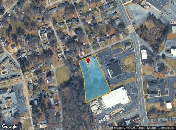
Property Record
508 Cook St, Kannapolis, NC 28083
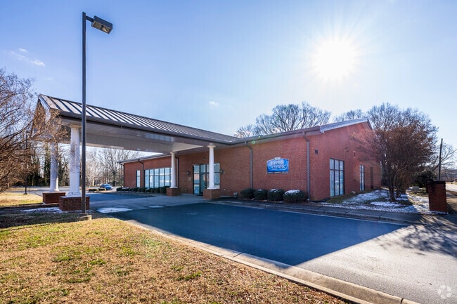
This Property Is For Sale
NEARBY LISTINGS FOR SALE OR LEASE
Property Detail
508 Cook St
5613-93-0762-0000
North Cannon Blvd
Funeralhome
SOUTH SIDE COOK ST
X
Cabarrus
3710561300K
North Carolina
2025
2.41 AC
2025
Cabarrus County
040705
Charlotte
8,876 SF
Charlotte-Concord-Gastonia, NC-SC
DEMOGRAPHICS near 508 Cook St
1 Mile
3 Mile
5 Mile
2024 Total Population
9,036
54,635
94,218
2029 Population
10,186
61,050
104,786
Pop Growth 2024-2029
+ 12.73%
+ 11.74%
+ 11.22%
Average Age
38
39
39
2024 Total Households
3,553
21,185
36,955
HH Growth 2024-2029
+ 11.43%
+ 10.70%
+ 10.19%
Median Household Inc
$48,776
$58,519
$58,496
Avg Household Size
2.50
2.50
2.50
2024 Avg HH Vehicles
2.00
2.00
2.00
Median Home Value
$161,312
$180,464
$198,904
Median Year Built
1961
1980
1983
Nearby Places
- Restaurants
- Banks
- Shops
- Fitness
- Groceries
PUBLIC TRANSPORTATION
COMMUTER RAIL
Kannapolis Station (Piedmont - North Carolina by Train (NC Train))
DRIVE
WALK
Distance
Kannapolis Station (Piedmont - North Carolina by Train (NC Train))
4 min
2.0 mi
AIRPORT
Concord-Padgett Regional
DRIVE
WALK
Distance
Concord-Padgett Regional
20 min
12.0 mi
Charlotte/Douglas International
DRIVE
WALK
Distance
Charlotte/Douglas International
45 min
32.3 mi
Freight Ports
Port of Wilmington
DRIVE
WALK
Distance
Port of Wilmington
260 min
201.3 mi
Nearby Properties
Address
Land Use
TOTAL SIZE
Lot Size
Zoning
Address
Land Use
TOTAL SIZE
Lot Size
Zoning
40,519 SF
20.12 AC
PD-TND
Address
Land Use
TOTAL SIZE
Lot Size
Zoning
276,070 SF
CC
Address
Land Use
TOTAL SIZE
Lot Size
Zoning
42,409 SF
16 AC
GC
Address
Land Use
TOTAL SIZE
Lot Size
Zoning
114,382 SF
24.64 AC
R4
Address
Land Use
TOTAL SIZE
Lot Size
Zoning
176,676 SF
31.80 AC
R4
Address
Land Use
TOTAL SIZE
Lot Size
Zoning
128,064 SF
2.68 AC
CC
Address
Land Use
TOTAL SIZE
Lot Size
Zoning
121,156 SF
3.57 AC
CC
Address
Land Use
TOTAL SIZE
Lot Size
Zoning
106,804 SF
1.81 AC
CC
Address
Land Use
TOTAL SIZE
Lot Size
Zoning
90,350 SF
10.20 AC
PID
Address
Land Use
TOTAL SIZE
Lot Size
Zoning
44,136 SF
15.42 AC
R18
Address
Land Use
TOTAL SIZE
Lot Size
Zoning
83,152 SF
7.11 AC
CC
Address
Land Use
TOTAL SIZE
Lot Size
Zoning
15,924 SF
16.90 AC
RC
Address
Land Use
TOTAL SIZE
Lot Size
Zoning
24,618 SF
21.33 AC
R18
Address
Land Use
TOTAL SIZE
Lot Size
Zoning
29,957 SF
18.10 AC
PID
Address
Land Use
TOTAL SIZE
Lot Size
Zoning
176,075 SF
2.35 AC
CC
Address
Land Use
TOTAL SIZE
Lot Size
Zoning
29,259 SF
8.48 AC
RC
Address
Land Use
TOTAL SIZE
Lot Size
Zoning
122,182 SF
16.70 AC
C-2
Address
Land Use
TOTAL SIZE
Lot Size
Zoning
114,250 SF
18.50 AC
RM-2
Address
Land Use
TOTAL SIZE
Lot Size
Zoning
5,308 SF
15.16 AC
RC
Address
Land Use
TOTAL SIZE
Lot Size
Zoning
18,288 SF
9.45 AC
RC
Address
Land Use
TOTAL SIZE
Lot Size
Zoning
88,934 SF
8 AC
PID
Address
Land Use
TOTAL SIZE
Lot Size
Zoning
207,899 SF
21.62 AC
C-2
Address
Land Use
TOTAL SIZE
Lot Size
Zoning
85,422 SF
6.30 AC
R8
Address
Land Use
TOTAL SIZE
Lot Size
Zoning
67,862 SF
1.77 AC
CC
Address
Land Use
TOTAL SIZE
Lot Size
Zoning
80,409 SF
11.15 AC
C-1
Address
Land Use
TOTAL SIZE
Lot Size
Zoning
12,010 SF
0.40 AC
CC
Address
Land Use
TOTAL SIZE
Lot Size
Zoning
134,754 SF
19.51 AC
O-I
Address
Land Use
TOTAL SIZE
Lot Size
Zoning
66,194 SF
2.94 AC
CC
Address
Land Use
TOTAL SIZE
Lot Size
Zoning
101,014 SF
1.84 AC
CC
Address
Land Use
TOTAL SIZE
Lot Size
Zoning
56,923 SF
2 AC
CC
The World's #1 Commercial Real Estate Marketplace
Connect with us
© 2025 CoStar Group
The information above has been obtained from sources believed reliable. While we do not doubt its accuracy we have not verified it and make no guarantee, warranty or representation about it. It is your responsibility to independently confirm its accuracy and completeness. Any projections, opinions, assumptions, or estimates used are for example only and do not represent the current or future performance of the property. The value of this transaction to you depends on tax and other factors which should be evaluated by your tax, financial, and legal advisors. You and your advisors should conduct a careful, independent investigation of the property to determine to your satisfaction the suitability of the property for your needs.