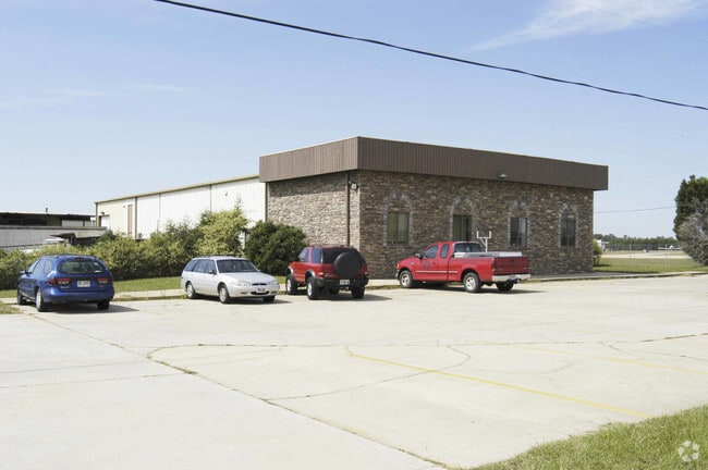
Property Record
508 Speedway Blvd, Hampton, GA 30228

Property Detail
508 Speedway Blvd
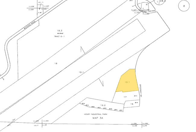
0003-01-019-001
LAND LOT: 254 /LAND DISTRICT: 6; INDUSTRIAL
Airport
Henry
M1
Georgia
B and X Area of moderate flood hazard, usually the area between the limits of the 100-year and 500-year floods.
254
2025
5.75 AC
2025
S Clayton/Henry Cnty
070504
Atlanta
10,800 SF
Atlanta-Sandy Springs-Roswell, GA
NEARBY LISTINGS FOR SALE OR LEASE
DEMOGRAPHICS near 508 Speedway Blvd
1 mile
3 mile
5 mile
2025 Total Population
131
16,594
53,300
2030 Population
141
17,578
55,244
Pop Growth 2025-2030
+ 7.63%
+ 5.93%
+ 3.65%
Average Age
41
37
37
2025 Total Households
48
5,590
17,557
HH Growth 2025-2030
+ 6.25%
+ 6.05%
+ 3.65%
Median Household Inc
$49,999
$76,486
$74,636
Avg Household Size
2.70
3.00
2.90
2025 Avg HH Vehicles
2.00
2.00
2.00
Median Home Value
$252,777
$293,476
$292,466
Median Year Built
1993
2002
2002
Nearby Places
Map Layers
Map Styles
 Street
 Aerial
Layers
 Traffic
 Biking
Places
Listings with unknown addresses are not visible on the map
- Restaurants
- Banks
- Shops
- Fitness
- Groceries
PUBLIC TRANSPORTATION
AIRPORT
Hartsfield - Jackson Atlanta International
Drive
Walk
Distance
Hartsfield - Jackson Atlanta International
37 min
21.4 mi
Freight Ports
Georgia Ports - Savannah
Drive
Walk
Distance
Georgia Ports - Savannah
261 min
230.4 mi
Nearby Properties
Address
Land Use
TOTAL SIZE
Lot Size
Zoning
Address
Land Use
TOTAL SIZE
Lot Size
Zoning
1,424,654 SF
172.86 AC
Address
Land Use
TOTAL SIZE
Lot Size
Zoning
39,373 SF
587.19 AC
M1
Address
Land Use
TOTAL SIZE
Lot Size
Zoning
640,693 SF
691.83 AC
PD
Address
Land Use
TOTAL SIZE
Lot Size
Zoning
224 SF
20 AC
C
Address
Land Use
TOTAL SIZE
Lot Size
Zoning
1,826 SF
486.41 AC
AG
Address
Land Use
TOTAL SIZE
Lot Size
Zoning
147,861 SF
36.79 AC
M1
Address
Land Use
TOTAL SIZE
Lot Size
Zoning
96.63 AC
PD
Address
Land Use
TOTAL SIZE
Lot Size
Zoning
11,312 SF
560 AC
RA
Address
Land Use
TOTAL SIZE
Lot Size
Zoning
8.44 AC
C
Address
Land Use
TOTAL SIZE
Lot Size
Zoning
41,568 SF
29.31 AC
M2
Address
Land Use
TOTAL SIZE
Lot Size
Zoning
1,404 SF
62.12 AC
RMH
Address
Land Use
TOTAL SIZE
Lot Size
Zoning
24,540 SF
26 AC
C1
Address
Land Use
TOTAL SIZE
Lot Size
Zoning
28,144 SF
22.16 AC
AG
Address
Land Use
TOTAL SIZE
Lot Size
Zoning
26.60 AC
C
Address
Land Use
TOTAL SIZE
Lot Size
Zoning
371,928 SF
10.16 AC
M1
Address
Land Use
TOTAL SIZE
Lot Size
Zoning
87,276 SF
5 AC
M1
Address
Land Use
TOTAL SIZE
Lot Size
Zoning
39,681 SF
6.19 AC
C2
Address
Land Use
TOTAL SIZE
Lot Size
Zoning
183,000 SF
6.40 AC
M2
Address
Land Use
TOTAL SIZE
Lot Size
Zoning
68,010 SF
8 AC
M1
Address
Land Use
TOTAL SIZE
Lot Size
Zoning
19,500 SF
3.09 AC
C
Address
Land Use
TOTAL SIZE
Lot Size
Zoning
274.66 AC
ER
Address
Land Use
TOTAL SIZE
Lot Size
Zoning
15,968 SF
2.96 AC
C2
Address
Land Use
TOTAL SIZE
Lot Size
Zoning
6,880 SF
7.89 AC
M2
Address
Land Use
TOTAL SIZE
Lot Size
Zoning
231.80 AC
AG
Address
Land Use
TOTAL SIZE
Lot Size
Zoning
7,191 SF
41.14 AC
RA
The World's #1 Commercial Real Estate Marketplace
Connect with us
© 2026 CoStar Group
The information above has been obtained from sources believed reliable. While we do not doubt its accuracy we have not verified it and make no guarantee, warranty or representation about it. It is your responsibility to independently confirm its accuracy and completeness. Any projections, opinions, assumptions, or estimates used are for example only and do not represent the current or future performance of the property. The value of this transaction to you depends on tax and other factors which should be evaluated by your tax, financial, and legal advisors. You and your advisors should conduct a careful, independent investigation of the property to determine to your satisfaction the suitability of the property for your needs.