Property Record
5080 Tin Top Rd, Weatherford, TX 76087
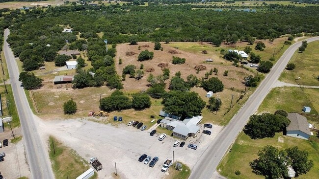
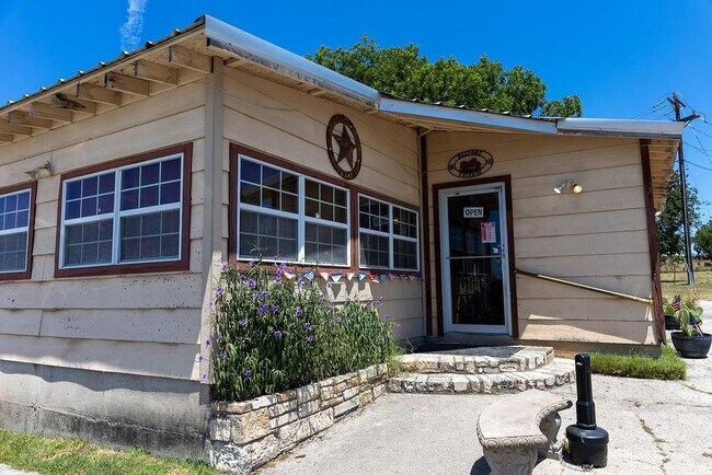
This Property Is For Sale
NEARBY LISTINGS FOR SALE OR LEASE
-
-
View all Weatherford listings for sale on LoopNet.com
Property Detail
5080 Tin Top Rd
R000063609
ACRES: 1.000 ABST: 2058, SURV: W H STEWART
Sfr
Parker
X
Texas
48221C0075E
9.05 AC
2024
Parker County
2025
Dallas/Ft Worth
140603
Dallas-Fort Worth-Arlington, TX
952 SF
DEMOGRAPHICS near 5080 Tin Top Rd
1 mile
3 mile
5 mile
2024 Total Population
653
5,996
11,255
2029 Population
1,019
9,398
17,517
Pop Growth 2024-2029
+ 56.05%
+ 56.74%
+ 55.64%
Average Age
40
39
40
2024 Total Households
233
2,059
4,029
HH Growth 2024-2029
+ 54.08%
+ 54.49%
+ 53.39%
Median Household Inc
$69,329
$65,629
$67,500
Avg Household Size
2.70
2.70
2.60
2024 Avg HH Vehicles
2.00
2.00
2.00
Median Home Value
$311,111
$252,478
$250,249
Median Year Built
2008
2007
2006
Nearby Places
Map Layers
Map Styles
 Street
 Aerial
Transit
 Traffic
 Biking
Places
Listings with unknown addresses are not visible on the map
- Restaurants
- Banks
- Shops
- Fitness
- Groceries
Nearby Properties
Address
Land Use
TOTAL SIZE
Lot Size
Zoning
Address
Land Use
TOTAL SIZE
Lot Size
Zoning
135.48 AC
Address
Land Use
TOTAL SIZE
Lot Size
Zoning
13,984 SF
1.34 AC
Address
Land Use
TOTAL SIZE
Lot Size
Zoning
7,715 SF
4.43 AC
Address
Land Use
TOTAL SIZE
Lot Size
Zoning
5,427 SF
6.63 AC
Address
Land Use
TOTAL SIZE
Lot Size
Zoning
6,881 SF
3.17 AC
Address
Land Use
TOTAL SIZE
Lot Size
Zoning
5,645 SF
3.28 AC
Address
Land Use
TOTAL SIZE
Lot Size
Zoning
2,520 SF
1 AC
Address
Land Use
TOTAL SIZE
Lot Size
Zoning
6,563 SF
2.58 AC
Address
Land Use
TOTAL SIZE
Lot Size
Zoning
7,526 SF
2.58 AC
Address
Land Use
TOTAL SIZE
Lot Size
Zoning
6,268 SF
2.07 AC
Address
Land Use
TOTAL SIZE
Lot Size
Zoning
5,009 SF
2.93 AC
Address
Land Use
TOTAL SIZE
Lot Size
Zoning
Address
Land Use
TOTAL SIZE
Lot Size
Zoning
8,803 SF
1 AC
Address
Land Use
TOTAL SIZE
Lot Size
Zoning
10,828 SF
5.75 AC
Address
Land Use
TOTAL SIZE
Lot Size
Zoning
7,238 SF
7.02 AC
Address
Land Use
TOTAL SIZE
Lot Size
Zoning
7,051 SF
2.44 AC
Address
Land Use
TOTAL SIZE
Lot Size
Zoning
8,010 SF
1 AC
Address
Land Use
TOTAL SIZE
Lot Size
Zoning
4,452 SF
2.24 AC
Address
Land Use
TOTAL SIZE
Lot Size
Zoning
5,754 SF
5.87 AC
Address
Land Use
TOTAL SIZE
Lot Size
Zoning
Address
Land Use
TOTAL SIZE
Lot Size
Zoning
6,705 SF
3.14 AC
Address
Land Use
TOTAL SIZE
Lot Size
Zoning
3,895 SF
8.33 AC
Address
Land Use
TOTAL SIZE
Lot Size
Zoning
4,865 SF
1.35 AC
Address
Land Use
TOTAL SIZE
Lot Size
Zoning
4,673 SF
1.89 AC
Address
Land Use
TOTAL SIZE
Lot Size
Zoning
Address
Land Use
TOTAL SIZE
Lot Size
Zoning
7,401 SF
Address
Land Use
TOTAL SIZE
Lot Size
Zoning
5,671 SF
1.51 AC
Address
Land Use
TOTAL SIZE
Lot Size
Zoning
6,103 SF
9.89 AC
Address
Land Use
TOTAL SIZE
Lot Size
Zoning
3,089 SF
1 AC
Address
Land Use
TOTAL SIZE
Lot Size
Zoning
5,967 SF
1.08 AC
The World's #1 Commercial Real Estate Marketplace
Connect with us
© 2026 CoStar Group
The information above has been obtained from sources believed reliable. While we do not doubt its accuracy we have not verified it and make no guarantee, warranty or representation about it. It is your responsibility to independently confirm its accuracy and completeness. Any projections, opinions, assumptions, or estimates used are for example only and do not represent the current or future performance of the property. The value of this transaction to you depends on tax and other factors which should be evaluated by your tax, financial, and legal advisors. You and your advisors should conduct a careful, independent investigation of the property to determine to your satisfaction the suitability of the property for your needs.