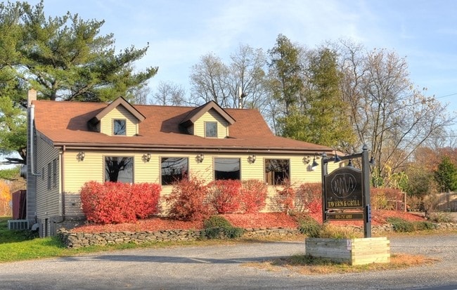
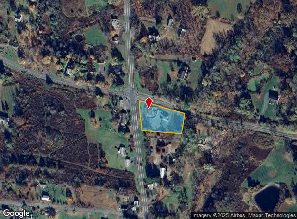
Property Record
5084 Route 9G, Tivoli, NY 12583
NEARBY LISTINGS FOR SALE OR LEASE
Property Detail
5084 Route 9G
134889-6174-00-813944-0000
1 AC 1498 0577 1464 0840
Restaurantbuilding
Dutchess
X
New York
36027C0017E
813
2025
1 AC
2024
Fishkill
150004
Westchester/So Connecticut
2,200 SF
Dutchess County-Putnam County, NY
DEMOGRAPHICS near 5084 Route 9G
1 Mile
3 Mile
5 Mile
2024 Total Population
934
6,348
22,019
2029 Population
898
6,238
21,868
Pop Growth 2024-2029
(3.85%)
(1.73%)
(0.69%)
Average Age
42
43
44
2024 Total Households
408
2,601
9,231
HH Growth 2024-2029
(4.17%)
(1.77%)
(0.68%)
Median Household Inc
$68,823
$70,991
$81,886
Avg Household Size
2.20
2.30
2.30
2024 Avg HH Vehicles
2.00
2.00
2.00
Median Home Value
$432,835
$384,570
$343,246
Median Year Built
1969
1964
1964
Nearby Places
- Restaurants
- Banks
- Shops
- Fitness
- Groceries
SALE & LEASE HISTORY
LISTING DATE
SALE/LEASE

Jul 29, 2024
For Sale
Nearby Properties
Address
Land Use
TOTAL SIZE
Lot Size
Zoning
Address
Land Use
TOTAL SIZE
Lot Size
Zoning
2,688 SF
301.70 AC
I
Address
Land Use
TOTAL SIZE
Lot Size
Zoning
105,815 SF
91.70 AC
I
Address
Land Use
TOTAL SIZE
Lot Size
Zoning
108,250 SF
16.40 AC
I
Address
Land Use
TOTAL SIZE
Lot Size
Zoning
81,289 SF
115.30 AC
I
Address
Land Use
TOTAL SIZE
Lot Size
Zoning
31,824 SF
84 AC
LDR
Address
Land Use
TOTAL SIZE
Lot Size
Zoning
78.11 AC
WC
Address
Land Use
TOTAL SIZE
Lot Size
Zoning
7.90 AC
03 - MULTI
Address
Land Use
TOTAL SIZE
Lot Size
Zoning
108,009 SF
54.40 AC
I
Address
Land Use
TOTAL SIZE
Lot Size
Zoning
2,634 SF
108.40 AC
RA
Address
Land Use
TOTAL SIZE
Lot Size
Zoning
4,788 SF
1.62 AC
R1.5
Address
Land Use
TOTAL SIZE
Lot Size
Zoning
41,213 SF
7.90 AC
02
Address
Land Use
TOTAL SIZE
Lot Size
Zoning
56,845 SF
17.70 AC
02 - SINGL
Address
Land Use
TOTAL SIZE
Lot Size
Zoning
21.70 AC
LC
Address
Land Use
TOTAL SIZE
Lot Size
Zoning
5,617 SF
228.26 AC
ABD
Address
Land Use
TOTAL SIZE
Lot Size
Zoning
36,004 SF
7.10 AC
05 - COMME
Address
Land Use
TOTAL SIZE
Lot Size
Zoning
13.90 AC
WC
Address
Land Use
TOTAL SIZE
Lot Size
Zoning
5,225 SF
432.29 AC
RD5
Address
Land Use
TOTAL SIZE
Lot Size
Zoning
5,664 SF
5.30 AC
WC
Address
Land Use
TOTAL SIZE
Lot Size
Zoning
2,400 SF
260.30 AC
RLD
Address
Land Use
TOTAL SIZE
Lot Size
Zoning
13,066 SF
149 AC
Address
Land Use
TOTAL SIZE
Lot Size
Zoning
6,695 SF
77.81 AC
RD3
Address
Land Use
TOTAL SIZE
Lot Size
Zoning
18,225 SF
29.30 AC
02 - SINGL
Address
Land Use
TOTAL SIZE
Lot Size
Zoning
2,872 SF
173.64 AC
ABD
Address
Land Use
TOTAL SIZE
Lot Size
Zoning
6,144 SF
3.30 AC
02 - SINGL
Address
Land Use
TOTAL SIZE
Lot Size
Zoning
2.55 AC
R3A
Address
Land Use
TOTAL SIZE
Lot Size
Zoning
11,404 SF
11.04 AC
03 - MULTI
Address
Land Use
TOTAL SIZE
Lot Size
Zoning
2,816 SF
133.58 AC
ABD
Address
Land Use
TOTAL SIZE
Lot Size
Zoning
3,760 SF
114.50 AC
ABD
Address
Land Use
TOTAL SIZE
Lot Size
Zoning
13,976 SF
5.91 AC
R1.5
Address
Land Use
TOTAL SIZE
Lot Size
Zoning
7,795 SF
0.28 AC
GB
The World's #1 Commercial Real Estate Marketplace
Connect with us
© 2025 CoStar Group
The information above has been obtained from sources believed reliable. While we do not doubt its accuracy we have not verified it and make no guarantee, warranty or representation about it. It is your responsibility to independently confirm its accuracy and completeness. Any projections, opinions, assumptions, or estimates used are for example only and do not represent the current or future performance of the property. The value of this transaction to you depends on tax and other factors which should be evaluated by your tax, financial, and legal advisors. You and your advisors should conduct a careful, independent investigation of the property to determine to your satisfaction the suitability of the property for your needs.