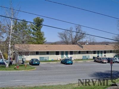
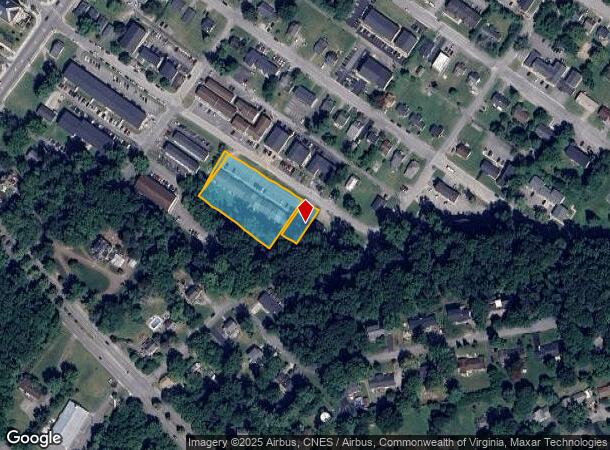
Property Record
509 Calhoun St, Radford, VA 24141
NEARBY LISTINGS FOR SALE OR LEASE
-
-
View all Radford listings for sale on LoopNet.com
Property Detail
509 Calhoun St
Blacksburg-Christiansburg-Radford, VA
PLAN A BL CO SEC G PTS LOT 1 THRU 13-1A
7-2-SC-G-1A-1TR11
Radford City
Multifamilydwelling
Virginia
X
1-13-1a
51155C0093H
1.32 AC
2025
Blacksburg & Wytheville
2025
Other Market Areas
010102
DEMOGRAPHICS near 509 Calhoun St
1 Mile
3 Mile
5 Mile
2024 Total Population
6,599
19,987
24,539
2029 Population
7,395
21,811
26,311
Pop Growth 2024-2029
+ 12.06%
+ 9.13%
+ 7.22%
Average Age
29
38
38
2024 Total Households
2,826
8,658
10,478
HH Growth 2024-2029
+ 11.78%
+ 8.88%
+ 7.12%
Median Household Inc
$25,461
$47,809
$50,425
Avg Household Size
2.00
2.20
2.20
2024 Avg HH Vehicles
2.00
2.00
2.00
Median Home Value
$226,035
$216,192
$219,337
Median Year Built
1980
1977
1978
Nearby Places
Map Layers
Map Styles
 Street
 Aerial
- Restaurants
- Banks
- Shops
- Fitness
- Groceries
Nearby Properties
Address
Land Use
TOTAL SIZE
Lot Size
Zoning
Address
Land Use
TOTAL SIZE
Lot Size
Zoning
45.01 AC
I1
Address
Land Use
TOTAL SIZE
Lot Size
Zoning
2.75 AC
C1
Address
Land Use
TOTAL SIZE
Lot Size
Zoning
25.18 AC
R3
Address
Land Use
TOTAL SIZE
Lot Size
Zoning
13.84 AC
Address
Land Use
TOTAL SIZE
Lot Size
Zoning
17.95 AC
CM1
Address
Land Use
TOTAL SIZE
Lot Size
Zoning
7.57 AC
Address
Land Use
TOTAL SIZE
Lot Size
Zoning
14.32 AC
CM1
Address
Land Use
TOTAL SIZE
Lot Size
Zoning
8.63 AC
I0
Address
Land Use
TOTAL SIZE
Lot Size
Zoning
0.25 AC
Address
Land Use
TOTAL SIZE
Lot Size
Zoning
13.63 AC
Address
Land Use
TOTAL SIZE
Lot Size
Zoning
183.50 AC
PUD
Address
Land Use
TOTAL SIZE
Lot Size
Zoning
15.33 AC
CM1
Address
Land Use
TOTAL SIZE
Lot Size
Zoning
2.96 AC
Address
Land Use
TOTAL SIZE
Lot Size
Zoning
2.44 AC
Address
Land Use
TOTAL SIZE
Lot Size
Zoning
6.69 AC
Address
Land Use
TOTAL SIZE
Lot Size
Zoning
30.09 AC
Address
Land Use
TOTAL SIZE
Lot Size
Zoning
88.40 AC
I0
Address
Land Use
TOTAL SIZE
Lot Size
Zoning
1.66 AC
Address
Land Use
TOTAL SIZE
Lot Size
Zoning
15.52 AC
CM1
Address
Land Use
TOTAL SIZE
Lot Size
Zoning
37,107 SF
2.15 AC
GB
Address
Land Use
TOTAL SIZE
Lot Size
Zoning
1.75 AC
GB
Address
Land Use
TOTAL SIZE
Lot Size
Zoning
5.27 AC
R3
Address
Land Use
TOTAL SIZE
Lot Size
Zoning
50.83 AC
Address
Land Use
TOTAL SIZE
Lot Size
Zoning
3.74 AC
Address
Land Use
TOTAL SIZE
Lot Size
Zoning
1.23 AC
A1
Address
Land Use
TOTAL SIZE
Lot Size
Zoning
7.12 AC
Address
Land Use
TOTAL SIZE
Lot Size
Zoning
7.93 AC
Address
Land Use
TOTAL SIZE
Lot Size
Zoning
3.53 AC
Address
Land Use
TOTAL SIZE
Lot Size
Zoning
3.82 AC
CM1
Address
Land Use
TOTAL SIZE
Lot Size
Zoning
7.07 AC
The World's #1 Commercial Real Estate Marketplace
Connect with us
© 2025 CoStar Group
The information above has been obtained from sources believed reliable. While we do not doubt its accuracy we have not verified it and make no guarantee, warranty or representation about it. It is your responsibility to independently confirm its accuracy and completeness. Any projections, opinions, assumptions, or estimates used are for example only and do not represent the current or future performance of the property. The value of this transaction to you depends on tax and other factors which should be evaluated by your tax, financial, and legal advisors. You and your advisors should conduct a careful, independent investigation of the property to determine to your satisfaction the suitability of the property for your needs.