Property Record
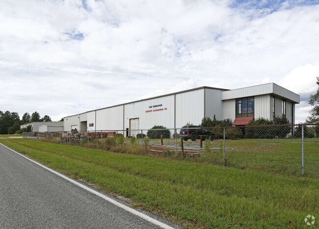
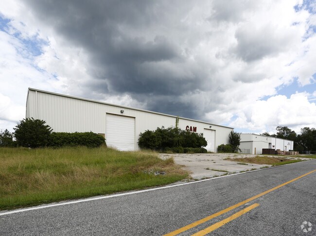
509 Gurleys Mill Rd, Princeton, NC 27569

Property Detail
509 Gurleys Mill Rd
04Q08004G
WEEKS 91/145
Lightindustrial
Johnston
COW
North Carolina
B and X Area of moderate flood hazard, usually the area between the limits of the 100-year and 500-year floods.
2.69 AC
2025
Johnston County
2025
Raleigh/Durham
040501
Raleigh-Cary, NC
11,000 SF
NEARBY LISTINGS FOR SALE OR LEASE
-
-
View all Princeton listings for lease on LoopNet.com
DEMOGRAPHICS near 509 Gurleys Mill Rd
1 mile
3 mile
5 mile
2025 Total Population
1,476
5,783
14,251
2030 Population
1,644
6,266
15,348
Pop Growth 2025-2030
+ 11.38%
+ 8.35%
+ 7.70%
Average Age
40
39
39
2025 Total Households
570
2,190
5,365
HH Growth 2025-2030
+ 11.40%
+ 8.40%
+ 7.74%
Median Household Inc
$42,968
$71,612
$75,042
Avg Household Size
2.60
2.60
2.60
2025 Avg HH Vehicles
2.00
2.00
2.00
Median Home Value
$250,000
$202,365
$193,552
Median Year Built
1982
1991
1992
Nearby Places
Map Layers
Map Styles
 Street
 Aerial
Layers
 Traffic
 Biking
Places
Listings with unknown addresses are not visible on the map
- Restaurants
- Banks
- Shops
- Fitness
- Groceries
PUBLIC TRANSPORTATION
COMMUTER RAIL
Selma (Carolinian - Amtrak, Palmetto - Amtrak)
Drive
Walk
Distance
Selma (Carolinian - Amtrak, Palmetto - Amtrak)
15 min
9.2 mi
Freight Ports
Port of Wilmington
Drive
Walk
Distance
Port of Wilmington
130 min
107.5 mi
SALE & LEASE HISTORY
LISTING DATE
SALE/LEASE

Mar 24, 2020
For Lease
Aug 26, 2019
For Sale
Nearby Properties
Address
Land Use
TOTAL SIZE
Lot Size
Zoning
Address
Land Use
TOTAL SIZE
Lot Size
Zoning
30,242 SF
13.12 AC
COW
Address
Land Use
TOTAL SIZE
Lot Size
Zoning
17,000 SF
33.85 AC
RAG
Address
Land Use
TOTAL SIZE
Lot Size
Zoning
27,156 SF
9.81 AC
COW
Address
Land Use
TOTAL SIZE
Lot Size
Zoning
19,854 SF
7.86 AC
COM
Address
Land Use
TOTAL SIZE
Lot Size
Zoning
3,840 SF
3.05 AC
REW
Address
Land Use
TOTAL SIZE
Lot Size
Zoning
22,400 SF
10.64 AC
Address
Land Use
TOTAL SIZE
Lot Size
Zoning
19,778 SF
0.77 AC
REW
Address
Land Use
TOTAL SIZE
Lot Size
Zoning
3,811 SF
1.90 AC
COW
Address
Land Use
TOTAL SIZE
Lot Size
Zoning
28,778 SF
3.51 AC
COW
Address
Land Use
TOTAL SIZE
Lot Size
Zoning
286.62 AC
IND
Address
Land Use
TOTAL SIZE
Lot Size
Zoning
13,080 SF
4.40 AC
REW
Address
Land Use
TOTAL SIZE
Lot Size
Zoning
3,750 SF
3.69 AC
COW
Address
Land Use
TOTAL SIZE
Lot Size
Zoning
276.05 AC
RAG
Address
Land Use
TOTAL SIZE
Lot Size
Zoning
21,860 SF
5.31 AC
COW
Address
Land Use
TOTAL SIZE
Lot Size
Zoning
4,802 SF
8.34 AC
COW
Address
Land Use
TOTAL SIZE
Lot Size
Zoning
4,000 SF
3.54 AC
COW
Address
Land Use
TOTAL SIZE
Lot Size
Zoning
3,065 SF
2.24 AC
RES
Address
Land Use
TOTAL SIZE
Lot Size
Zoning
11,918 SF
2.73 AC
IND
Address
Land Use
TOTAL SIZE
Lot Size
Zoning
10,576 SF
1.65 AC
COW
Address
Land Use
TOTAL SIZE
Lot Size
Zoning
129 AC
IND
Address
Land Use
TOTAL SIZE
Lot Size
Zoning
8,745 SF
6.37 AC
COW
Address
Land Use
TOTAL SIZE
Lot Size
Zoning
240 AC
RAG
Address
Land Use
TOTAL SIZE
Lot Size
Zoning
7,050 SF
6.01 AC
COM
Address
Land Use
TOTAL SIZE
Lot Size
Zoning
8,730 SF
1.51 AC
REW
Address
Land Use
TOTAL SIZE
Lot Size
Zoning
9,104 SF
108.21 AC
RAG
Address
Land Use
TOTAL SIZE
Lot Size
Zoning
2,501 SF
1.36 AC
COW
Address
Land Use
TOTAL SIZE
Lot Size
Zoning
4,131 SF
0.75 AC
COW
Address
Land Use
TOTAL SIZE
Lot Size
Zoning
2,601 SF
1.38 AC
RES
Address
Land Use
TOTAL SIZE
Lot Size
Zoning
1,600 SF
193.11 AC
RAG
The World's #1 Commercial Real Estate Marketplace
Connect with us
© 2026 CoStar Group
The information above has been obtained from sources believed reliable. While we do not doubt its accuracy we have not verified it and make no guarantee, warranty or representation about it. It is your responsibility to independently confirm its accuracy and completeness. Any projections, opinions, assumptions, or estimates used are for example only and do not represent the current or future performance of the property. The value of this transaction to you depends on tax and other factors which should be evaluated by your tax, financial, and legal advisors. You and your advisors should conduct a careful, independent investigation of the property to determine to your satisfaction the suitability of the property for your needs.