Property Record
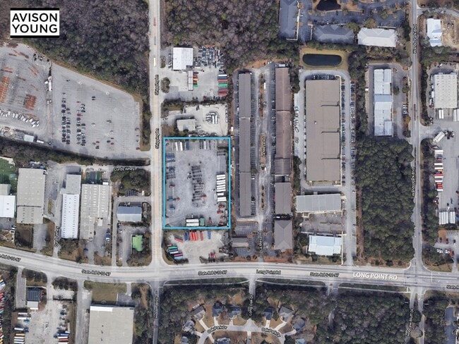
509 Long Point Rd, Mount Pleasant, SC 29464

Property Detail
509 Long Point Rd
Charleston-North Charleston, SC
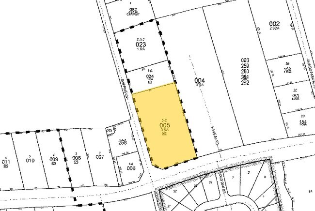
DESCRIPTION -LOT 5-C BLK A SITE NAME -INTERSECTION OF RAT HALL RD
537-00-00-005
CHARLESTON
Commercialacreage
South Carolina
B and X Area of moderate flood hazard, usually the area between the limits of the 100-year and 500-year floods.
5-c
2025
3.93 AC
2024
East Islands/Mt Pleasant
004614
Charleston/N Charleston
NEARBY LISTINGS FOR SALE OR LEASE
-
-
View all Mount Pleasant listings for lease on LoopNet.com
DEMOGRAPHICS near 509 Long Point Rd
1 mile
3 mile
5 mile
2024 Total Population
5,626
46,146
90,589
2029 Population
5,781
48,272
95,815
Pop Growth 2024-2029
+ 2.76%
+ 4.61%
+ 5.77%
Average Age
41
42
41
2024 Total Households
2,147
19,955
38,939
HH Growth 2024-2029
+ 2.70%
+ 4.80%
+ 6.05%
Median Household Inc
$136,218
$113,371
$113,096
Avg Household Size
2.60
2.20
2.30
2024 Avg HH Vehicles
2.00
2.00
2.00
Median Home Value
$765,017
$784,143
$796,105
Median Year Built
1996
1994
1997
Nearby Places
Map Layers
Map Styles
 Street
 Aerial
Transit
 Traffic
 Biking
Places
Listings with unknown addresses are not visible on the map
- Restaurants
- Banks
- Shops
- Fitness
- Groceries
PUBLIC TRANSPORTATION
AIRPORT
Charleston AFB/International
Drive
Walk
Distance
Charleston AFB/International
25 min
17.3 mi
Freight Ports
Wando Welch Terminal
Drive
Walk
Distance
Wando Welch Terminal
1 min
0.6 mi
SALE & LEASE HISTORY
LISTING DATE
SALE/LEASE

Sep 21, 2020
For Lease
Nearby Properties
Address
Land Use
TOTAL SIZE
Lot Size
Zoning
Address
Land Use
TOTAL SIZE
Lot Size
Zoning
247,883 SF
16.26 AC
Address
Land Use
TOTAL SIZE
Lot Size
Zoning
29,118 SF
7.83 AC
CHARLESTON
Address
Land Use
TOTAL SIZE
Lot Size
Zoning
372,400 SF
5.59 AC
CHARLESTON
Address
Land Use
TOTAL SIZE
Lot Size
Zoning
62,366 SF
12.65 AC
CHARLESTON
Address
Land Use
TOTAL SIZE
Lot Size
Zoning
181,318 SF
4.87 AC
CHARLESTON
Address
Land Use
TOTAL SIZE
Lot Size
Zoning
168,570 SF
8.75 AC
CHARLESTON
Address
Land Use
TOTAL SIZE
Lot Size
Zoning
Address
Land Use
TOTAL SIZE
Lot Size
Zoning
75,596 SF
39.82 AC
CHARLESTON
Address
Land Use
TOTAL SIZE
Lot Size
Zoning
88,540 SF
3.32 AC
CHARLESTON
Address
Land Use
TOTAL SIZE
Lot Size
Zoning
480.58 AC
CHARLESTON
Address
Land Use
TOTAL SIZE
Lot Size
Zoning
21,291 SF
6.13 AC
CHARLESTON
Address
Land Use
TOTAL SIZE
Lot Size
Zoning
58,764 SF
25 AC
CHARLESTON
Address
Land Use
TOTAL SIZE
Lot Size
Zoning
29,614 SF
4.08 AC
CHARLESTON
Address
Land Use
TOTAL SIZE
Lot Size
Zoning
41,174 SF
3.90 AC
CHARLESTON
Address
Land Use
TOTAL SIZE
Lot Size
Zoning
21,432 SF
1.27 AC
CHARLESTON
Address
Land Use
TOTAL SIZE
Lot Size
Zoning
40,130 SF
3.76 AC
CHARLESTON
Address
Land Use
TOTAL SIZE
Lot Size
Zoning
9,520 SF
2.04 AC
CHARLESTON
Address
Land Use
TOTAL SIZE
Lot Size
Zoning
11,300 SF
1.62 AC
CHARLESTON
Address
Land Use
TOTAL SIZE
Lot Size
Zoning
6.33 AC
CHARLESTON
Address
Land Use
TOTAL SIZE
Lot Size
Zoning
30,014 SF
2.24 AC
CHARLESTON
Address
Land Use
TOTAL SIZE
Lot Size
Zoning
23.21 AC
CHARLESTON
Address
Land Use
TOTAL SIZE
Lot Size
Zoning
4,128 SF
0.41 AC
CHARLESTON
Address
Land Use
TOTAL SIZE
Lot Size
Zoning
18,316 SF
14.16 AC
Address
Land Use
TOTAL SIZE
Lot Size
Zoning
21,866 SF
1.25 AC
CHARLESTON
Address
Land Use
TOTAL SIZE
Lot Size
Zoning
17,553 SF
2.01 AC
CHARLESTON
Address
Land Use
TOTAL SIZE
Lot Size
Zoning
15,957 SF
3.80 AC
Address
Land Use
TOTAL SIZE
Lot Size
Zoning
3,462 SF
24.85 AC
Address
Land Use
TOTAL SIZE
Lot Size
Zoning
25,080 SF
1.90 AC
CHARLESTON
Address
Land Use
TOTAL SIZE
Lot Size
Zoning
CHARLESTON
The World's #1 Commercial Real Estate Marketplace
Connect with us
© 2026 CoStar Group
The information above has been obtained from sources believed reliable. While we do not doubt its accuracy we have not verified it and make no guarantee, warranty or representation about it. It is your responsibility to independently confirm its accuracy and completeness. Any projections, opinions, assumptions, or estimates used are for example only and do not represent the current or future performance of the property. The value of this transaction to you depends on tax and other factors which should be evaluated by your tax, financial, and legal advisors. You and your advisors should conduct a careful, independent investigation of the property to determine to your satisfaction the suitability of the property for your needs.