Property Record
509 W Front St, Roanoke, IL 61561
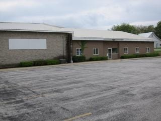

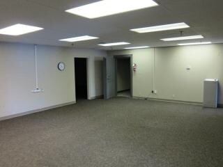
Property Detail
509 W Front St
10-22-201-012
T27N - R1W - S22 BK 3 PT BK 2 & PAR ADJ W SD C GOZINGERS ADDN
Industrialgeneral
Woodford
A Areas with a 1% annual chance of flooding and a 26% chance of flooding over the life of a 30-year mortgage.
Illinois
2025
8.33 AC
2025
Woodford County
030300
Peoria
97,490 SF
Peoria, IL
NEARBY LISTINGS FOR SALE OR LEASE
-
-
View all Roanoke listings for lease on LoopNet.com
DEMOGRAPHICS near 509 W Front St
1 mile
3 mile
5 mile
2025 Total Population
1,995
2,256
2,914
2030 Population
1,968
2,225
2,877
Pop Growth 2025-2030
(1.35%)
(1.37%)
(1.27%)
Average Age
42
42
42
2025 Total Households
775
876
1,130
HH Growth 2025-2030
(1.42%)
(1.48%)
(1.42%)
Median Household Inc
$81,845
$81,690
$78,396
Avg Household Size
2.50
2.50
2.60
2025 Avg HH Vehicles
2.00
2.00
2.00
Median Home Value
$177,442
$177,550
$179,130
Median Year Built
1962
1962
1960
Nearby Places
Map Layers
Map Styles
 Street
 Aerial
Layers
 Traffic
 Biking
Places
Listings with unknown addresses are not visible on the map
- Restaurants
- Banks
- Shops
- Fitness
- Groceries
PUBLIC TRANSPORTATION
AIRPORT
General Downing - Peoria International
Drive
Walk
Distance
General Downing - Peoria International
53 min
32.6 mi
Central Il Regional/Bloomington-Normal
Drive
Walk
Distance
Central Il Regional/Bloomington-Normal
63 min
43.0 mi
SALE & LEASE HISTORY
LISTING DATE
SALE/LEASE

Sep 24, 2016
For Sale
Aug 10, 2017
For Lease
Aug 10, 2017
For Sale
Nearby Properties
Address
Land Use
TOTAL SIZE
Lot Size
Zoning
Address
Land Use
TOTAL SIZE
Lot Size
Zoning
10.79 AC
Address
Land Use
TOTAL SIZE
Lot Size
Zoning
Address
Land Use
TOTAL SIZE
Lot Size
Zoning
16,570 SF
5.30 AC
Address
Land Use
TOTAL SIZE
Lot Size
Zoning
4,380 SF
0.92 AC
Address
Land Use
TOTAL SIZE
Lot Size
Zoning
1.52 AC
Address
Land Use
TOTAL SIZE
Lot Size
Zoning
3,346 SF
7 AC
Address
Land Use
TOTAL SIZE
Lot Size
Zoning
3,000 SF
0.41 AC
Address
Land Use
TOTAL SIZE
Lot Size
Zoning
0.24 AC
Address
Land Use
TOTAL SIZE
Lot Size
Zoning
2,536 SF
7.99 AC
Address
Land Use
TOTAL SIZE
Lot Size
Zoning
4,640 SF
74 AC
Address
Land Use
TOTAL SIZE
Lot Size
Zoning
4,368 SF
19.82 AC
Address
Land Use
TOTAL SIZE
Lot Size
Zoning
2.91 AC
Address
Land Use
TOTAL SIZE
Lot Size
Zoning
1.90 AC
Address
Land Use
TOTAL SIZE
Lot Size
Zoning
72.70 AC
Address
Land Use
TOTAL SIZE
Lot Size
Zoning
1,132 SF
1.50 AC
Address
Land Use
TOTAL SIZE
Lot Size
Zoning
5,760 SF
39 AC
Address
Land Use
TOTAL SIZE
Lot Size
Zoning
2,456 SF
1.77 AC
Address
Land Use
TOTAL SIZE
Lot Size
Zoning
1,366 SF
1.93 AC
Address
Land Use
TOTAL SIZE
Lot Size
Zoning
2,886 SF
46.66 AC
Address
Land Use
TOTAL SIZE
Lot Size
Zoning
3,314 SF
80.03 AC
Address
Land Use
TOTAL SIZE
Lot Size
Zoning
2,618 SF
80 AC
Address
Land Use
TOTAL SIZE
Lot Size
Zoning
3,968 SF
4.99 AC
Address
Land Use
TOTAL SIZE
Lot Size
Zoning
95.52 AC
Address
Land Use
TOTAL SIZE
Lot Size
Zoning
5,642 SF
2.85 AC
Address
Land Use
TOTAL SIZE
Lot Size
Zoning
3,104 SF
5.17 AC
Address
Land Use
TOTAL SIZE
Lot Size
Zoning
3,762 SF
39.62 AC
Address
Land Use
TOTAL SIZE
Lot Size
Zoning
2,616 SF
39.70 AC
The World's #1 Commercial Real Estate Marketplace
Connect with us
© 2026 CoStar Group
The information above has been obtained from sources believed reliable. While we do not doubt its accuracy we have not verified it and make no guarantee, warranty or representation about it. It is your responsibility to independently confirm its accuracy and completeness. Any projections, opinions, assumptions, or estimates used are for example only and do not represent the current or future performance of the property. The value of this transaction to you depends on tax and other factors which should be evaluated by your tax, financial, and legal advisors. You and your advisors should conduct a careful, independent investigation of the property to determine to your satisfaction the suitability of the property for your needs.