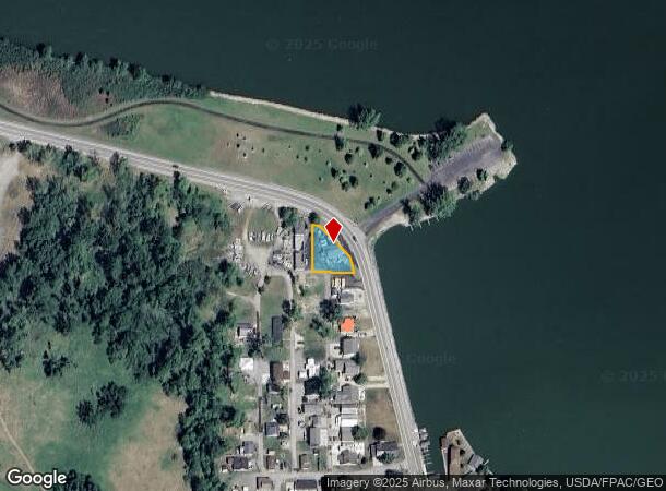
Property Record
509 W Main St, Russells Point, OH 43348

NEARBY LISTINGS FOR SALE OR LEASE
Property Detail
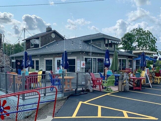
509 W Main St
52-032-05-02-001-000
Russels Point
Restaurantbuilding
0002 35-6-8
X
Logan
39091C0132E
Ohio
2024
0.22 AC
2024
Ohio South Area
004200
Other Market Areas
1,424 SF
Bellefontaine, OH
DEMOGRAPHICS near 509 W Main St
1 Mile
3 Mile
5 Mile
2024 Total Population
2,017
9,543
11,970
2029 Population
2,127
9,995
12,505
Pop Growth 2024-2029
+ 5.45%
+ 4.74%
+ 4.47%
Average Age
44
47
47
2024 Total Households
930
4,601
5,675
HH Growth 2024-2029
+ 5.27%
+ 4.83%
+ 4.60%
Median Household Inc
$46,842
$54,917
$57,331
Avg Household Size
2.20
2.00
2.10
2024 Avg HH Vehicles
2.00
2.00
2.00
Median Home Value
$155,194
$190,876
$195,420
Median Year Built
1974
1975
1976
Nearby Places
Map Layers
Map Styles
 Street
 Aerial
- Restaurants
- Banks
- Shops
- Fitness
- Groceries
SALE & LEASE HISTORY
LISTING DATE
SALE/LEASE

Jul 02, 2021
For Sale
Nearby Properties
Address
Land Use
TOTAL SIZE
Lot Size
Zoning
Address
Land Use
TOTAL SIZE
Lot Size
Zoning
133,600 SF
49.42 AC
Address
Land Use
TOTAL SIZE
Lot Size
Zoning
72,752 SF
58.34 AC
Address
Land Use
TOTAL SIZE
Lot Size
Zoning
2,152 SF
73.14 AC
Address
Land Use
TOTAL SIZE
Lot Size
Zoning
10.84 AC
Address
Land Use
TOTAL SIZE
Lot Size
Zoning
27,750 SF
4.60 AC
Address
Land Use
TOTAL SIZE
Lot Size
Zoning
4,872 SF
5 AC
Address
Land Use
TOTAL SIZE
Lot Size
Zoning
798 SF
2.47 AC
Address
Land Use
TOTAL SIZE
Lot Size
Zoning
322.96 AC
Address
Land Use
TOTAL SIZE
Lot Size
Zoning
41,050 SF
9.36 AC
Address
Land Use
TOTAL SIZE
Lot Size
Zoning
5,400 SF
39.97 AC
Address
Land Use
TOTAL SIZE
Lot Size
Zoning
82.55 AC
Address
Land Use
TOTAL SIZE
Lot Size
Zoning
5,192 SF
2.32 AC
Address
Land Use
TOTAL SIZE
Lot Size
Zoning
1,558 SF
66.04 AC
Address
Land Use
TOTAL SIZE
Lot Size
Zoning
12,000 SF
7.66 AC
Address
Land Use
TOTAL SIZE
Lot Size
Zoning
232.36 AC
Address
Land Use
TOTAL SIZE
Lot Size
Zoning
Address
Land Use
TOTAL SIZE
Lot Size
Zoning
10,004 SF
2.06 AC
Address
Land Use
TOTAL SIZE
Lot Size
Zoning
7,825 SF
0.64 AC
Address
Land Use
TOTAL SIZE
Lot Size
Zoning
Address
Land Use
TOTAL SIZE
Lot Size
Zoning
6.90 AC
Address
Land Use
TOTAL SIZE
Lot Size
Zoning
168 AC
Address
Land Use
TOTAL SIZE
Lot Size
Zoning
Address
Land Use
TOTAL SIZE
Lot Size
Zoning
4.85 AC
Address
Land Use
TOTAL SIZE
Lot Size
Zoning
4.23 AC
Address
Land Use
TOTAL SIZE
Lot Size
Zoning
1,774 SF
0.58 AC
Address
Land Use
TOTAL SIZE
Lot Size
Zoning
148.39 AC
Address
Land Use
TOTAL SIZE
Lot Size
Zoning
164.73 AC
Address
Land Use
TOTAL SIZE
Lot Size
Zoning
144.36 AC
Address
Land Use
TOTAL SIZE
Lot Size
Zoning
135.30 AC
Address
Land Use
TOTAL SIZE
Lot Size
Zoning
15,645 SF
2.50 AC
The World's #1 Commercial Real Estate Marketplace
Connect with us
© 2025 CoStar Group
The information above has been obtained from sources believed reliable. While we do not doubt its accuracy we have not verified it and make no guarantee, warranty or representation about it. It is your responsibility to independently confirm its accuracy and completeness. Any projections, opinions, assumptions, or estimates used are for example only and do not represent the current or future performance of the property. The value of this transaction to you depends on tax and other factors which should be evaluated by your tax, financial, and legal advisors. You and your advisors should conduct a careful, independent investigation of the property to determine to your satisfaction the suitability of the property for your needs.