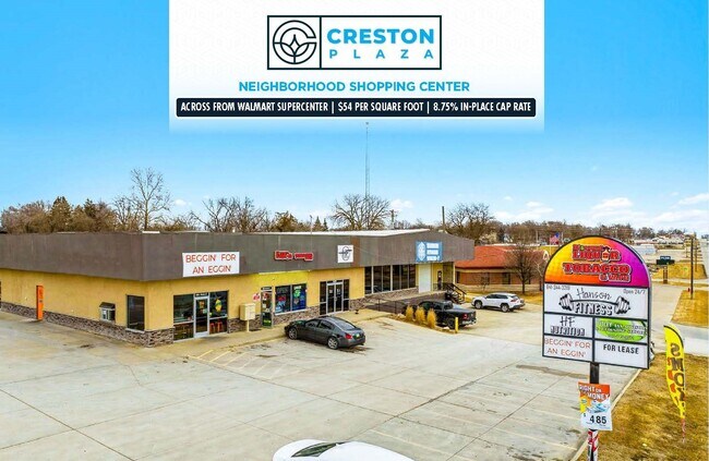
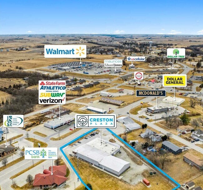
Property Record
509 W Taylor St, Creston, IA 50801
NEARBY LISTINGS FOR SALE OR LEASE
-
-
View all Creston listings for sale on LoopNet.com
Property Detail
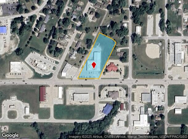
509 W Taylor St
0512327009
WC SEC B LOTS 266 THRU 270 & W 46 FT VAC STREET LYG E & ADJ AS MEASURED ALONG N LINE US 34 & EX S 3 FT LOT 266 FOR ROAD
Storebuilding
Union
X
Iowa
19175C0136D
266-270
2025
1.82 AC
2025
Iowa West Area
190200
Other Market Areas
16,320 SF
DEMOGRAPHICS near 509 W Taylor St
1 Mile
3 Mile
5 Mile
2024 Total Population
4,174
7,993
8,359
2029 Population
4,112
7,822
8,174
Pop Growth 2024-2029
(1.49%)
(2.14%)
(2.21%)
Average Age
40
41
41
2024 Total Households
1,881
3,473
3,618
HH Growth 2024-2029
(1.38%)
(2.13%)
(2.21%)
Median Household Inc
$42,938
$49,379
$50,346
Avg Household Size
2.10
2.10
2.10
2024 Avg HH Vehicles
2.00
2.00
2.00
Median Home Value
$88,048
$120,275
$124,542
Median Year Built
1948
1958
1958
Nearby Places
Map Layers
Map Styles
 Street
 Aerial
- Restaurants
- Banks
- Shops
- Fitness
- Groceries
PUBLIC TRANSPORTATION
COMMUTER RAIL
Creston Amtrak (California Zephyr - Amtrak)
DRIVE
WALK
Distance
Creston Amtrak (California Zephyr - Amtrak)
2 min
16 min
0.8 mi
Freight Ports
Tulsa Port Of Catoosa
DRIVE
WALK
Distance
Tulsa Port Of Catoosa
466 min
395.6 mi
SALE & LEASE HISTORY
LISTING DATE
SALE/LEASE

Mar 26, 2025
For Sale
Jan 30, 2017
For Lease
Nearby Properties
Address
Land Use
TOTAL SIZE
Lot Size
Zoning
Address
Land Use
TOTAL SIZE
Lot Size
Zoning
9,316 SF
47.90 AC
Address
Land Use
TOTAL SIZE
Lot Size
Zoning
151,620 SF
21.13 AC
Address
Land Use
TOTAL SIZE
Lot Size
Zoning
1,080 SF
39.75 AC
Address
Land Use
TOTAL SIZE
Lot Size
Zoning
159,175 SF
21.14 AC
Address
Land Use
TOTAL SIZE
Lot Size
Zoning
1,776 SF
10.78 AC
Address
Land Use
TOTAL SIZE
Lot Size
Zoning
10,880 SF
35.67 AC
Address
Land Use
TOTAL SIZE
Lot Size
Zoning
77,046 SF
9.50 AC
Address
Land Use
TOTAL SIZE
Lot Size
Zoning
640 SF
2.79 AC
Address
Land Use
TOTAL SIZE
Lot Size
Zoning
15,106 SF
3 AC
Address
Land Use
TOTAL SIZE
Lot Size
Zoning
28,798 SF
3.71 AC
Address
Land Use
TOTAL SIZE
Lot Size
Zoning
34,252 SF
42.50 AC
Address
Land Use
TOTAL SIZE
Lot Size
Zoning
228,750 SF
12.69 AC
Address
Land Use
TOTAL SIZE
Lot Size
Zoning
19,444 SF
2.41 AC
Address
Land Use
TOTAL SIZE
Lot Size
Zoning
4,900 SF
1.50 AC
Address
Land Use
TOTAL SIZE
Lot Size
Zoning
34,450 SF
3.06 AC
Address
Land Use
TOTAL SIZE
Lot Size
Zoning
28,546 SF
0.67 AC
Address
Land Use
TOTAL SIZE
Lot Size
Zoning
151,184 SF
9.31 AC
Address
Land Use
TOTAL SIZE
Lot Size
Zoning
19,178 SF
1.34 AC
Address
Land Use
TOTAL SIZE
Lot Size
Zoning
66,392 SF
10 AC
Address
Land Use
TOTAL SIZE
Lot Size
Zoning
4,925 SF
1.43 AC
Address
Land Use
TOTAL SIZE
Lot Size
Zoning
4,494 SF
1.04 AC
Address
Land Use
TOTAL SIZE
Lot Size
Zoning
3,480 SF
1.74 AC
Address
Land Use
TOTAL SIZE
Lot Size
Zoning
9,908 SF
4.49 AC
Address
Land Use
TOTAL SIZE
Lot Size
Zoning
2,880 SF
6.21 AC
Address
Land Use
TOTAL SIZE
Lot Size
Zoning
7,348 SF
0.43 AC
Address
Land Use
TOTAL SIZE
Lot Size
Zoning
8,000 SF
1.54 AC
Address
Land Use
TOTAL SIZE
Lot Size
Zoning
14,000 SF
17.39 AC
Address
Land Use
TOTAL SIZE
Lot Size
Zoning
3,632 SF
2.85 AC
Address
Land Use
TOTAL SIZE
Lot Size
Zoning
20,461 SF
1.95 AC
Address
Land Use
TOTAL SIZE
Lot Size
Zoning
18,800 SF
10.19 AC
The World's #1 Commercial Real Estate Marketplace
Connect with us
© 2025 CoStar Group
The information above has been obtained from sources believed reliable. While we do not doubt its accuracy we have not verified it and make no guarantee, warranty or representation about it. It is your responsibility to independently confirm its accuracy and completeness. Any projections, opinions, assumptions, or estimates used are for example only and do not represent the current or future performance of the property. The value of this transaction to you depends on tax and other factors which should be evaluated by your tax, financial, and legal advisors. You and your advisors should conduct a careful, independent investigation of the property to determine to your satisfaction the suitability of the property for your needs.