Property Record
5090 E Hill Rd, Grand Blanc, MI 48439


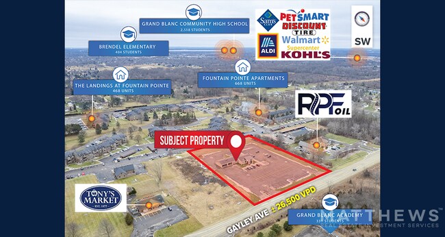
NEARBY LISTINGS FOR SALE OR LEASE
Property Detail
5090 E Hill Rd
12-11-100-004
N-248-B A POL BEG S 89* 28' 30 SEC E 700 FT FR NW COR OF SEC TH S 89* 28' 30 SEC E 300 FT TH S 0* 00' 20 SEC W 473 FT TH N
Commercialnec
Genesee
X
Michigan
26049C0328D
3.26 AC
2024
Flint
2025
Detroit
011214
Flint, MI
3,583 SF
DEMOGRAPHICS near 5090 E Hill Rd
1 Mile
3 Mile
5 Mile
2024 Total Population
5,855
32,830
84,686
2029 Population
5,691
31,934
82,498
Pop Growth 2024-2029
(2.80%)
(2.73%)
(2.58%)
Average Age
39
40
40
2024 Total Households
2,340
13,220
34,664
HH Growth 2024-2029
(2.82%)
(2.70%)
(2.61%)
Median Household Inc
$74,452
$70,316
$58,341
Avg Household Size
2.50
2.40
2.40
2024 Avg HH Vehicles
2.00
2.00
2.00
Median Home Value
$192,628
$210,399
$177,660
Median Year Built
1975
1976
1972
Nearby Places
Map Layers
Map Styles
 Street
 Aerial
- Restaurants
- Banks
- Shops
- Fitness
- Groceries
PUBLIC TRANSPORTATION
COMMUTER RAIL
Flint Amtrak Station (Blue Water - Amtrak)
DRIVE
WALK
Distance
Flint Amtrak Station (Blue Water - Amtrak)
14 min
7.2 mi
AIRPORT
Bishop International
DRIVE
WALK
Distance
Bishop International
25 min
9.2 mi
Freight Ports
Port of Toledo
DRIVE
WALK
Distance
Port of Toledo
139 min
106.2 mi
SALE & LEASE HISTORY
LISTING DATE
SALE/LEASE

Sep 24, 2016
For Sale
Feb 15, 2024
For Sale
Nearby Properties
Address
Land Use
TOTAL SIZE
Lot Size
Zoning
Address
Land Use
TOTAL SIZE
Lot Size
Zoning
507,562 SF
39.37 AC
HDM
Address
Land Use
TOTAL SIZE
Lot Size
Zoning
51.26 AC
HDM
Address
Land Use
TOTAL SIZE
Lot Size
Zoning
155,220 SF
33.46 AC
GC
Address
Land Use
TOTAL SIZE
Lot Size
Zoning
33.65 AC
MDM
Address
Land Use
TOTAL SIZE
Lot Size
Zoning
210,684 SF
27.06 AC
GC
Address
Land Use
TOTAL SIZE
Lot Size
Zoning
612,305 SF
116.49 AC
I-2
Address
Land Use
TOTAL SIZE
Lot Size
Zoning
157,756 SF
21.17 AC
MDM
Address
Land Use
TOTAL SIZE
Lot Size
Zoning
78,517 SF
16.80 AC
GC
Address
Land Use
TOTAL SIZE
Lot Size
Zoning
125,825 SF
13.01 AC
B-2
Address
Land Use
TOTAL SIZE
Lot Size
Zoning
674,049 SF
24.02 AC
I-2
Address
Land Use
TOTAL SIZE
Lot Size
Zoning
64,897 SF
1.86 AC
GC
Address
Land Use
TOTAL SIZE
Lot Size
Zoning
88,701 SF
10.27 AC
GC
Address
Land Use
TOTAL SIZE
Lot Size
Zoning
137,169 SF
18.50 AC
GC
Address
Land Use
TOTAL SIZE
Lot Size
Zoning
210.33 AC
MHP
Address
Land Use
TOTAL SIZE
Lot Size
Zoning
9.88 AC
HDM
Address
Land Use
TOTAL SIZE
Lot Size
Zoning
66,576 SF
5.98 AC
OS-1
Address
Land Use
TOTAL SIZE
Lot Size
Zoning
24.38 AC
RM
Address
Land Use
TOTAL SIZE
Lot Size
Zoning
91,726 SF
7.28 AC
HDM
Address
Land Use
TOTAL SIZE
Lot Size
Zoning
41,853 SF
4.54 AC
OS
Address
Land Use
TOTAL SIZE
Lot Size
Zoning
24,670 SF
9.62 AC
GC
Address
Land Use
TOTAL SIZE
Lot Size
Zoning
42,672 SF
I-1
Address
Land Use
TOTAL SIZE
Lot Size
Zoning
22,026 SF
2.59 AC
GC
Address
Land Use
TOTAL SIZE
Lot Size
Zoning
82,400 SF
5.90 AC
PUD
Address
Land Use
TOTAL SIZE
Lot Size
Zoning
2,829 SF
75.78 AC
RMH
Address
Land Use
TOTAL SIZE
Lot Size
Zoning
132,480 SF
10.99 AC
HDMF
Address
Land Use
TOTAL SIZE
Lot Size
Zoning
61,102 SF
4.40 AC
B-2
Address
Land Use
TOTAL SIZE
Lot Size
Zoning
107,184 SF
4.67 AC
HDMF
Address
Land Use
TOTAL SIZE
Lot Size
Zoning
115,108 SF
9.40 AC
HDMF
Address
Land Use
TOTAL SIZE
Lot Size
Zoning
80,109 SF
7.25 AC
R-T
Address
Land Use
TOTAL SIZE
Lot Size
Zoning
24,603 SF
4.90 AC
OS
The World's #1 Commercial Real Estate Marketplace
Connect with us
© 2026 CoStar Group
The information above has been obtained from sources believed reliable. While we do not doubt its accuracy we have not verified it and make no guarantee, warranty or representation about it. It is your responsibility to independently confirm its accuracy and completeness. Any projections, opinions, assumptions, or estimates used are for example only and do not represent the current or future performance of the property. The value of this transaction to you depends on tax and other factors which should be evaluated by your tax, financial, and legal advisors. You and your advisors should conduct a careful, independent investigation of the property to determine to your satisfaction the suitability of the property for your needs.