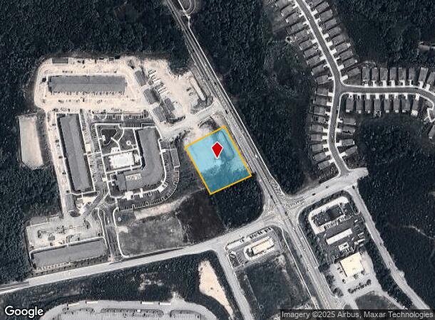
Property Record
5135 Campbellton Fairburn Rd, Union City, GA 30291
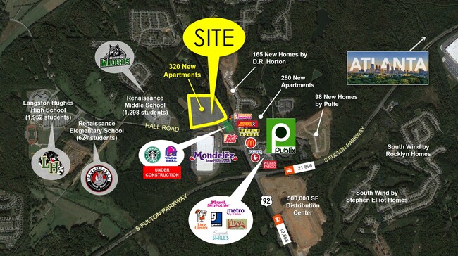
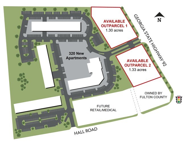
NEARBY LISTINGS FOR SALE OR LEASE
Property Detail
5135 Campbellton Fairburn Rd
Atlanta-Sandy Springs-Roswell, GA
Fulton
09F-3000-0117-260-9
Georgia
Commercialacreage
1.34 AC
0
North Clayton/Airport
2025
Atlanta
010524
DEMOGRAPHICS near 5135 Campbellton Fairburn Rd
1 Mile
3 Mile
5 Mile
2024 Total Population
3,664
28,650
70,146
2029 Population
3,756
29,727
72,619
Pop Growth 2024-2029
+ 2.51%
+ 3.76%
+ 3.53%
Average Age
38
38
38
2024 Total Households
1,343
9,904
24,480
HH Growth 2024-2029
+ 2.53%
+ 3.88%
+ 3.62%
Median Household Inc
$79,715
$88,286
$83,043
Avg Household Size
2.60
2.80
2.80
2024 Avg HH Vehicles
2.00
2.00
2.00
Median Home Value
$326,894
$266,898
$258,418
Median Year Built
2000
2003
2003
Nearby Places
Map Layers
Map Styles
 Street
 Aerial
- Restaurants
- Banks
- Shops
- Fitness
- Groceries
PUBLIC TRANSPORTATION
AIRPORT
Hartsfield - Jackson Atlanta International
DRIVE
WALK
Distance
Hartsfield - Jackson Atlanta International
23 min
14.9 mi
SALE & LEASE HISTORY
LISTING DATE
SALE/LEASE

Sep 26, 2022
For Lease
Nearby Properties
Address
Land Use
TOTAL SIZE
Lot Size
Zoning
Address
Land Use
TOTAL SIZE
Lot Size
Zoning
14.13 AC
TCMU
Address
Land Use
TOTAL SIZE
Lot Size
Zoning
74.44 AC
Address
Land Use
TOTAL SIZE
Lot Size
Zoning
545,664 SF
27.64 AC
AG1
Address
Land Use
TOTAL SIZE
Lot Size
Zoning
595,060 SF
62.71 AC
Address
Land Use
TOTAL SIZE
Lot Size
Zoning
1,325,500 SF
101.81 AC
AG1
Address
Land Use
TOTAL SIZE
Lot Size
Zoning
1,226,360 SF
18.72 AC
AG1
Address
Land Use
TOTAL SIZE
Lot Size
Zoning
1,052,500 SF
184.50 AC
AG1
Address
Land Use
TOTAL SIZE
Lot Size
Zoning
351,523 SF
116.48 AC
AG1
Address
Land Use
TOTAL SIZE
Lot Size
Zoning
2,042,096 SF
30.07 AC
MIXU
Address
Land Use
TOTAL SIZE
Lot Size
Zoning
14.83 AC
AG1
Address
Land Use
TOTAL SIZE
Lot Size
Zoning
156,882 SF
25 AC
AG1
Address
Land Use
TOTAL SIZE
Lot Size
Zoning
572,000 SF
46.35 AC
AG1
Address
Land Use
TOTAL SIZE
Lot Size
Zoning
499,950 SF
63.40 AC
AG1
Address
Land Use
TOTAL SIZE
Lot Size
Zoning
1,320,344 SF
0.35 AC
MIX
Address
Land Use
TOTAL SIZE
Lot Size
Zoning
24.53 AC
Address
Land Use
TOTAL SIZE
Lot Size
Zoning
1,566 SF
41.68 AC
AG1
Address
Land Use
TOTAL SIZE
Lot Size
Zoning
327,822 SF
0.16 AC
MIX
Address
Land Use
TOTAL SIZE
Lot Size
Zoning
169,212 SF
0.20 AC
MIX
Address
Land Use
TOTAL SIZE
Lot Size
Zoning
31.25 AC
Address
Land Use
TOTAL SIZE
Lot Size
Zoning
83,102 SF
10.75 AC
MIX
Address
Land Use
TOTAL SIZE
Lot Size
Zoning
45.90 AC
AG1
Address
Land Use
TOTAL SIZE
Lot Size
Zoning
88.01 AC
Address
Land Use
TOTAL SIZE
Lot Size
Zoning
29,612 SF
6.67 AC
MIX
Address
Land Use
TOTAL SIZE
Lot Size
Zoning
138.20 AC
TCMU
Address
Land Use
TOTAL SIZE
Lot Size
Zoning
48.17 AC
Address
Land Use
TOTAL SIZE
Lot Size
Zoning
69.70 AC
CUP
Address
Land Use
TOTAL SIZE
Lot Size
Zoning
Address
Land Use
TOTAL SIZE
Lot Size
Zoning
81.54 AC
AG1
Address
Land Use
TOTAL SIZE
Lot Size
Zoning
2,615 SF
0.78 AC
Address
Land Use
TOTAL SIZE
Lot Size
Zoning
29,764 SF
7.20 AC
AG1
The World's #1 Commercial Real Estate Marketplace
Connect with us
© 2025 CoStar Group
The information above has been obtained from sources believed reliable. While we do not doubt its accuracy we have not verified it and make no guarantee, warranty or representation about it. It is your responsibility to independently confirm its accuracy and completeness. Any projections, opinions, assumptions, or estimates used are for example only and do not represent the current or future performance of the property. The value of this transaction to you depends on tax and other factors which should be evaluated by your tax, financial, and legal advisors. You and your advisors should conduct a careful, independent investigation of the property to determine to your satisfaction the suitability of the property for your needs.