Property Record
5096 Ne 62Nd Ave, Altoona, IA 50009
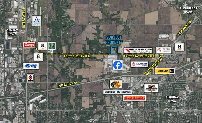
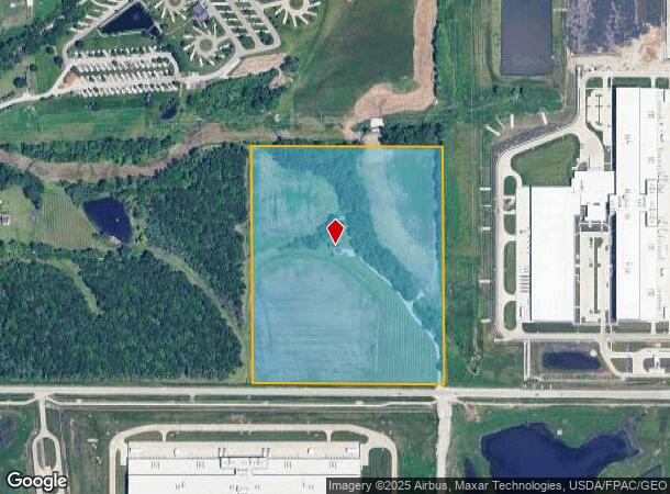
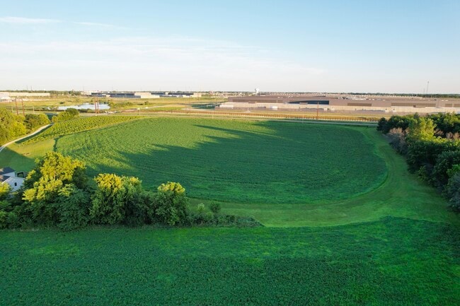
This Property Is For Sale
NEARBY LISTINGS FOR SALE OR LEASE
Property Detail
5096 Ne 62Nd Ave
Des Moines-West Des Moines, IA
Sec 03-79-23
190-00012005000
Polk
Sfr
Iowa
A
29.61 AC
19153C0220F
Northeast
1,858 SF
Des Moines
DEMOGRAPHICS near 5096 Ne 62Nd Ave
1 Mile
3 Mile
5 Mile
2024 Total Population
426
16,960
68,786
2029 Population
448
18,770
75,054
Pop Growth 2024-2029
+ 5.16%
+ 10.67%
+ 9.11%
Average Age
40
38
39
2024 Total Households
163
6,636
26,517
HH Growth 2024-2029
+ 5.52%
+ 10.94%
+ 9.35%
Median Household Inc
$32,916
$75,485
$77,523
Avg Household Size
2.40
2.50
2.50
2024 Avg HH Vehicles
2.00
2.00
2.00
Median Home Value
$236,363
$233,369
$225,335
Median Year Built
1969
1996
1994
Nearby Places
- Restaurants
- Banks
- Shops
- Fitness
- Groceries
PUBLIC TRANSPORTATION
AIRPORT
Des Moines International
DRIVE
WALK
Distance
Des Moines International
31 min
15.7 mi
Nearby Properties
Address
Land Use
TOTAL SIZE
Lot Size
Zoning
Address
Land Use
TOTAL SIZE
Lot Size
Zoning
1,232,488 SF
184.19 AC
Address
Land Use
TOTAL SIZE
Lot Size
Zoning
1,089,208 SF
145.90 AC
Address
Land Use
TOTAL SIZE
Lot Size
Zoning
1,018,608 SF
190.56 AC
Address
Land Use
TOTAL SIZE
Lot Size
Zoning
2,693,534 SF
167.13 AC
Address
Land Use
TOTAL SIZE
Lot Size
Zoning
549,615 SF
149.20 AC
C6
Address
Land Use
TOTAL SIZE
Lot Size
Zoning
497,587 SF
31.46 AC
Address
Land Use
TOTAL SIZE
Lot Size
Zoning
459,000 SF
19.69 AC
Address
Land Use
TOTAL SIZE
Lot Size
Zoning
350,879 SF
16.14 AC
Address
Land Use
TOTAL SIZE
Lot Size
Zoning
397,563 SF
18.25 AC
Address
Land Use
TOTAL SIZE
Lot Size
Zoning
333,079 SF
34.07 AC
Address
Land Use
TOTAL SIZE
Lot Size
Zoning
146,138 SF
22.78 AC
C-3
Address
Land Use
TOTAL SIZE
Lot Size
Zoning
327,600 SF
16.57 AC
Address
Land Use
TOTAL SIZE
Lot Size
Zoning
212,388 SF
40.63 AC
Address
Land Use
TOTAL SIZE
Lot Size
Zoning
359,441 SF
173.80 AC
C6
Address
Land Use
TOTAL SIZE
Lot Size
Zoning
265,726 SF
14.76 AC
Address
Land Use
TOTAL SIZE
Lot Size
Zoning
300,000 SF
18.95 AC
Address
Land Use
TOTAL SIZE
Lot Size
Zoning
300,000 SF
20.09 AC
Address
Land Use
TOTAL SIZE
Lot Size
Zoning
320,429 SF
22.34 AC
R3
Address
Land Use
TOTAL SIZE
Lot Size
Zoning
270,000 SF
18.35 AC
Address
Land Use
TOTAL SIZE
Lot Size
Zoning
270,000 SF
14.55 AC
Address
Land Use
TOTAL SIZE
Lot Size
Zoning
220,740 SF
23.21 AC
Address
Land Use
TOTAL SIZE
Lot Size
Zoning
195,500 SF
15.03 AC
Address
Land Use
TOTAL SIZE
Lot Size
Zoning
195,500 SF
8.09 AC
Address
Land Use
TOTAL SIZE
Lot Size
Zoning
136,900 SF
28.82 AC
Address
Land Use
TOTAL SIZE
Lot Size
Zoning
167,308 SF
16.46 AC
Address
Land Use
TOTAL SIZE
Lot Size
Zoning
142,118 SF
10.59 AC
PUD
Address
Land Use
TOTAL SIZE
Lot Size
Zoning
205,728 SF
21.74 AC
Address
Land Use
TOTAL SIZE
Lot Size
Zoning
157,500 SF
13.71 AC
Address
Land Use
TOTAL SIZE
Lot Size
Zoning
141,616 SF
20.41 AC
Address
Land Use
TOTAL SIZE
Lot Size
Zoning
135,824 SF
13.22 AC
The World's #1 Commercial Real Estate Marketplace
Connect with us
© 2025 CoStar Group
The information above has been obtained from sources believed reliable. While we do not doubt its accuracy we have not verified it and make no guarantee, warranty or representation about it. It is your responsibility to independently confirm its accuracy and completeness. Any projections, opinions, assumptions, or estimates used are for example only and do not represent the current or future performance of the property. The value of this transaction to you depends on tax and other factors which should be evaluated by your tax, financial, and legal advisors. You and your advisors should conduct a careful, independent investigation of the property to determine to your satisfaction the suitability of the property for your needs.