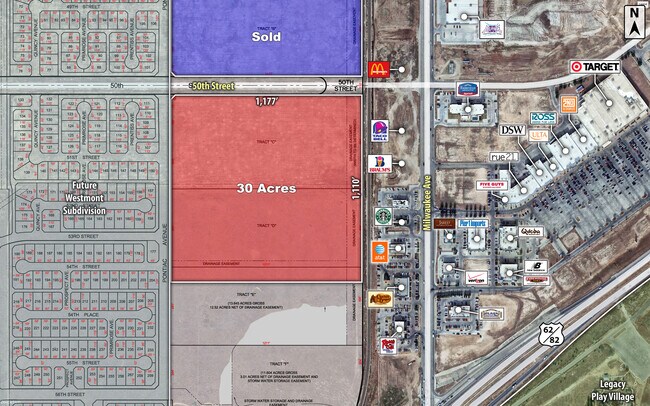
Property Record
50Th St, Lubbock, TX 79407

Property Detail
50Th St
Lubbock, TX
BLK AK SEC 35 AB 230 TR 9A2A & TR 8C1 LOWERY SUB AC: 22.765
R345308
LUBBOCK
Residentialacreage
Texas
2024
22.77 AC
2025
North Outer Lubbock
010419
Lubbock
NEARBY LISTINGS FOR SALE OR LEASE
DEMOGRAPHICS near 50Th St
1 mile
3 mile
5 mile
2025 Total Population
2,915
75,056
168,824
2030 Population
3,126
78,621
176,594
Pop Growth 2025-2030
+ 7.24%
+ 4.75%
+ 4.60%
Average Age
36
36
37
2025 Total Households
1,335
31,777
69,443
HH Growth 2025-2030
+ 7.49%
+ 5.06%
+ 4.89%
Median Household Inc
$90,451
$61,230
$65,156
Avg Household Size
2.20
2.30
2.40
2025 Avg HH Vehicles
2.00
2.00
2.00
Median Home Value
$231,457
$227,948
$242,436
Median Year Built
2010
1993
1988
Nearby Places
Map Layers
Map Styles
 Street
 Aerial
Transit
 Traffic
 Biking
Places
Listings with unknown addresses are not visible on the map
- Restaurants
- Banks
- Shops
- Fitness
- Groceries
PUBLIC TRANSPORTATION
AIRPORT
Lubbock Preston Smith International
Drive
Walk
Distance
Lubbock Preston Smith International
32 min
18.4 mi
Freight Ports
Tulsa Port Of Catoosa
Drive
Walk
Distance
Tulsa Port Of Catoosa
514 min
475.8 mi
SALE & LEASE HISTORY
LISTING DATE
SALE/LEASE

Apr 18, 2019
For Sale
Nearby Properties
Address
Land Use
TOTAL SIZE
Lot Size
Zoning
Address
Land Use
TOTAL SIZE
Lot Size
Zoning
791,096 SF
63.76 AC
Address
Land Use
TOTAL SIZE
Lot Size
Zoning
111,769 SF
25.03 AC
Address
Land Use
TOTAL SIZE
Lot Size
Zoning
236,871 SF
6.77 AC
Address
Land Use
TOTAL SIZE
Lot Size
Zoning
276,552 SF
12.05 AC
Address
Land Use
TOTAL SIZE
Lot Size
Zoning
290,322 SF
11.96 AC
Address
Land Use
TOTAL SIZE
Lot Size
Zoning
303,724 SF
17.32 AC
Address
Land Use
TOTAL SIZE
Lot Size
Zoning
289,796 SF
14.67 AC
Address
Land Use
TOTAL SIZE
Lot Size
Zoning
247,870 SF
11.48 AC
Address
Land Use
TOTAL SIZE
Lot Size
Zoning
176,412 SF
12.27 AC
Address
Land Use
TOTAL SIZE
Lot Size
Zoning
207,374 SF
15.51 AC
Address
Land Use
TOTAL SIZE
Lot Size
Zoning
108,363 SF
11.35 AC
Address
Land Use
TOTAL SIZE
Lot Size
Zoning
215,338 SF
26.49 AC
Address
Land Use
TOTAL SIZE
Lot Size
Zoning
169,556 SF
12 AC
Address
Land Use
TOTAL SIZE
Lot Size
Zoning
196,103 SF
12.33 AC
Address
Land Use
TOTAL SIZE
Lot Size
Zoning
246,478 SF
13 AC
Address
Land Use
TOTAL SIZE
Lot Size
Zoning
156,495 SF
15.85 AC
Address
Land Use
TOTAL SIZE
Lot Size
Zoning
138,202 SF
11.33 AC
Address
Land Use
TOTAL SIZE
Lot Size
Zoning
24,540 SF
8.06 AC
Address
Land Use
TOTAL SIZE
Lot Size
Zoning
178,895 SF
7.85 AC
Address
Land Use
TOTAL SIZE
Lot Size
Zoning
156,038 SF
12.05 AC
Address
Land Use
TOTAL SIZE
Lot Size
Zoning
69.21 AC
Address
Land Use
TOTAL SIZE
Lot Size
Zoning
190,032 SF
11.89 AC
Address
Land Use
TOTAL SIZE
Lot Size
Zoning
103,560 SF
7.04 AC
Address
Land Use
TOTAL SIZE
Lot Size
Zoning
79,733 SF
3.14 AC
Address
Land Use
TOTAL SIZE
Lot Size
Zoning
100,132 SF
8.42 AC
Address
Land Use
TOTAL SIZE
Lot Size
Zoning
172,627 SF
8.12 AC
Address
Land Use
TOTAL SIZE
Lot Size
Zoning
139,501 SF
10.56 AC
Address
Land Use
TOTAL SIZE
Lot Size
Zoning
220,236 SF
13.42 AC
Address
Land Use
TOTAL SIZE
Lot Size
Zoning
198,209 SF
9.98 AC
Address
Land Use
TOTAL SIZE
Lot Size
Zoning
75,154 SF
6.95 AC
The World's #1 Commercial Real Estate Marketplace
Connect with us
© 2026 CoStar Group
The information above has been obtained from sources believed reliable. While we do not doubt its accuracy we have not verified it and make no guarantee, warranty or representation about it. It is your responsibility to independently confirm its accuracy and completeness. Any projections, opinions, assumptions, or estimates used are for example only and do not represent the current or future performance of the property. The value of this transaction to you depends on tax and other factors which should be evaluated by your tax, financial, and legal advisors. You and your advisors should conduct a careful, independent investigation of the property to determine to your satisfaction the suitability of the property for your needs.