Property Record
51 20Th St W, Rosamond, CA 93560
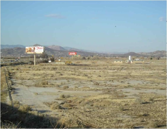

Property Detail
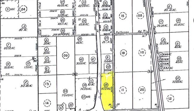
51 20Th St W
473-022-18-00-1
CC 1018
Commercialnec
KERN
M-2 PD FPS
California
B and X Area of moderate flood hazard, usually the area between the limits of the 100-year and 500-year floods.
47.27 AC
2024
SE Outlying Kern County
2025
Bakersfield
005514
Bakersfield-Delano, CA
736 SF
NEARBY LISTINGS FOR SALE OR LEASE
DEMOGRAPHICS near 51 20Th St W
1 mile
3 mile
5 mile
2025 Total Population
183
10,355
21,964
2030 Population
184
10,634
22,521
Pop Growth 2025-2030
+ 0.55%
+ 2.69%
+ 2.54%
Average Age
37
35
36
2025 Total Households
64
3,494
7,582
HH Growth 2025-2030
0.00%
+ 2.58%
+ 2.57%
Median Household Inc
$42,500
$73,802
$75,108
Avg Household Size
2.90
2.90
2.80
2025 Avg HH Vehicles
2.00
2.00
2.00
Median Home Value
$139,473
$394,669
$346,831
Median Year Built
2001
1993
1993
Nearby Places
Map Layers
Map Styles
 Street
 Aerial
Layers
 Traffic
 Biking
Places
Listings with unknown addresses are not visible on the map
- Restaurants
- Banks
- Shops
- Fitness
- Groceries
SALE & LEASE HISTORY
LISTING DATE
SALE/LEASE

Sep 24, 2016
For Sale
Nearby Properties
Address
Land Use
TOTAL SIZE
Lot Size
Zoning
Address
Land Use
TOTAL SIZE
Lot Size
Zoning
78,737 SF
2.73 AC
C2
Address
Land Use
TOTAL SIZE
Lot Size
Zoning
17,253 SF
2.91 AC
C2
Address
Land Use
TOTAL SIZE
Lot Size
Zoning
11,575 SF
4.16 AC
R3
Address
Land Use
TOTAL SIZE
Lot Size
Zoning
Address
Land Use
TOTAL SIZE
Lot Size
Zoning
47,337 SF
3.65 AC
C2
Address
Land Use
TOTAL SIZE
Lot Size
Zoning
12,240 SF
5.30 AC
M-2
Address
Land Use
TOTAL SIZE
Lot Size
Zoning
Address
Land Use
TOTAL SIZE
Lot Size
Zoning
19,519 SF
9.32 AC
M-3
Address
Land Use
TOTAL SIZE
Lot Size
Zoning
22,352 SF
8.64 AC
M-3
Address
Land Use
TOTAL SIZE
Lot Size
Zoning
4,951 SF
1.49 AC
C1
Address
Land Use
TOTAL SIZE
Lot Size
Zoning
Address
Land Use
TOTAL SIZE
Lot Size
Zoning
31,608 SF
2.72 AC
R-1
Address
Land Use
TOTAL SIZE
Lot Size
Zoning
21,000 SF
2.44 AC
C-2 PD
Address
Land Use
TOTAL SIZE
Lot Size
Zoning
27,340 SF
1.54 AC
R-3 PD
Address
Land Use
TOTAL SIZE
Lot Size
Zoning
27,340 SF
1.54 AC
R-3 PD
Address
Land Use
TOTAL SIZE
Lot Size
Zoning
9,350 SF
0.73 AC
R-3
Address
Land Use
TOTAL SIZE
Lot Size
Zoning
2,400 SF
0.82 AC
M-1
Address
Land Use
TOTAL SIZE
Lot Size
Zoning
Address
Land Use
TOTAL SIZE
Lot Size
Zoning
1,120 SF
6.17 AC
M2
Address
Land Use
TOTAL SIZE
Lot Size
Zoning
1,913 SF
0.96 AC
C-2 PD
Address
Land Use
TOTAL SIZE
Lot Size
Zoning
2.13 AC
C-2 PD
Address
Land Use
TOTAL SIZE
Lot Size
Zoning
9,100 SF
1.02 AC
C-2
Address
Land Use
TOTAL SIZE
Lot Size
Zoning
4,530 SF
0.84 AC
C2
Address
Land Use
TOTAL SIZE
Lot Size
Zoning
1,842 SF
2.55 AC
R-3 PD FPS
Address
Land Use
TOTAL SIZE
Lot Size
Zoning
4.27 AC
R-3 PD
Address
Land Use
TOTAL SIZE
Lot Size
Zoning
5.58 AC
R-1
Address
Land Use
TOTAL SIZE
Lot Size
Zoning
28.93 AC
M-2
Address
Land Use
TOTAL SIZE
Lot Size
Zoning
7,378 SF
0.66 AC
C-2
Address
Land Use
TOTAL SIZE
Lot Size
Zoning
3,066 SF
0.81 AC
C-2 PD
Address
Land Use
TOTAL SIZE
Lot Size
Zoning
80.41 AC
M-3
The World's #1 Commercial Real Estate Marketplace
Connect with us
© 2026 CoStar Group
The information above has been obtained from sources believed reliable. While we do not doubt its accuracy we have not verified it and make no guarantee, warranty or representation about it. It is your responsibility to independently confirm its accuracy and completeness. Any projections, opinions, assumptions, or estimates used are for example only and do not represent the current or future performance of the property. The value of this transaction to you depends on tax and other factors which should be evaluated by your tax, financial, and legal advisors. You and your advisors should conduct a careful, independent investigation of the property to determine to your satisfaction the suitability of the property for your needs.